Palestinian drivers wait in traffic to enter Jerusalem at Qalandiya checkpoint between Jerusalem and Ramallah, November 10, 2015.

Credit: 

Majdi Mohammed, AP Photo

Blog Post

Palestinian Jerusalemites Invent Apps to Navigate Unpredictable Checkpoint Statuses

“I almost got shot at the checkpoint.” This has become a common phrase for Palestinian Jerusalemites who pass through Israeli military checkpoints, where they are required to present identification papers to the Israeli officer on duty in order to proceed.

As of October 7, 2023, when Hamas staged Operation al-Aqsa Flood and Israel declared war on Gaza, driving from place to place has been particularly confusing: Are the roads completely blocked? Are they open only on certain hours of the day? Have the checkpoints been changed? Are there entrances one may not know about?

This is because Israel passed emergency laws that allowed it to change all the rules of the roads at any time. Checkpoints were completely closed for weeks, then partially opened at unpredictable times. Soldiers generally became much more likely to shoot on a hair-trigger, elevating the risk of getting lost or making a wrong turn.

So, for Palestinians, trying to figure out ways to travel and move has become an even more perplexing experience.

Israel passed emergency laws that allowed it to change all the rules of the roads at any time.

A Risky Venture

Many Palestinian Jerusalemites run frequent errands and have important logistics to attend to in the rest of the occupied West Bank; many of them study, work, or have family in major area destinations including Bethlehem, Ramallah, and Jericho.

However, for drivers (let alone passengers), attempting to access the Israeli checkpoints that would allow them to move to and from those places is a dubious and unpredictable endeavor. Information is not easy to come by, and the internet—which is what most people around the world use these days—can be tricky if not downright dangerous: Online maps do not show the Israeli military checkpoints. In fact, once a driver reaches any Palestinian area, the existing international apps and online maps such as Google Maps warn users not to enter “forbidden/dangerous/illegal areas” (i.e., Area “A,” marked with warning signs; areas where Palestinian live).

Online maps do not show the Israeli military checkpoints.

One could only imagine what kind of trouble a mistake on the road could lead to: Driving a vehicle with a blue Palestinian or yellow Israeli plate number makes a big difference, as does the ID one carries and one’s general appearance. As a Palestinian turns onto any road, he or she must consider: What’s allowed? What’s absolutely forbidden? Some of this, as it turns out, could be a matter of pure guessing. In the worst-case scenario, if the seemingly confused driver looks visibly Arab, the Israeli soldier might get suspicious of a possible terror attack attempt and act upon a “defensive instinct” by shooting (generally to kill). God forbid the car should malfunction or the driver lose control of the car, causing it to move haphazardly towards soldiers—that has resulted in certain death many times. Or the opposite could happen—someone in a yellow-plated car making a wrong turn could be attacked by Palestinians waiting for area settlers. This also could result in damage to the car (from a thrown stone) or loss of life (from a sniper or an improvised explosive device). 

Besides having to figure out which areas are allowed for one to access and which are forbidden in geographic locations where the “rules” frequently change without notice as per Israeli policies, reaching those areas can be especially tricky: in recent months, most Palestinian Jerusalemites themselves do not have firm knowledge of how and when they can enter major cities like Jericho, Ramallah, or Bethlehem—the latter being less than 10 km away. 

As a Palestinian turns onto any road, he or she must consider: What’s allowed? What’s absolutely forbidden?

Local Innovation Comes to the Rescue

“Necessity is the mother of invention,” they say. Since the war started, the need to know the conditions on the ground has been so pressing for Palestinians that online pages, groups, and even an app were created to help drivers and pedestrians navigate the military zones. Online sources that have become popular in this respect are Facebook groups that monitor the conditions of the Allenby Bridge, Qalandiya checkpoint, and others; a WhatsApp page where users send updates about the road between Jerusalem and Ramallah; and Azmeh—an app dedicated to the conditions of all checkpoints at large.

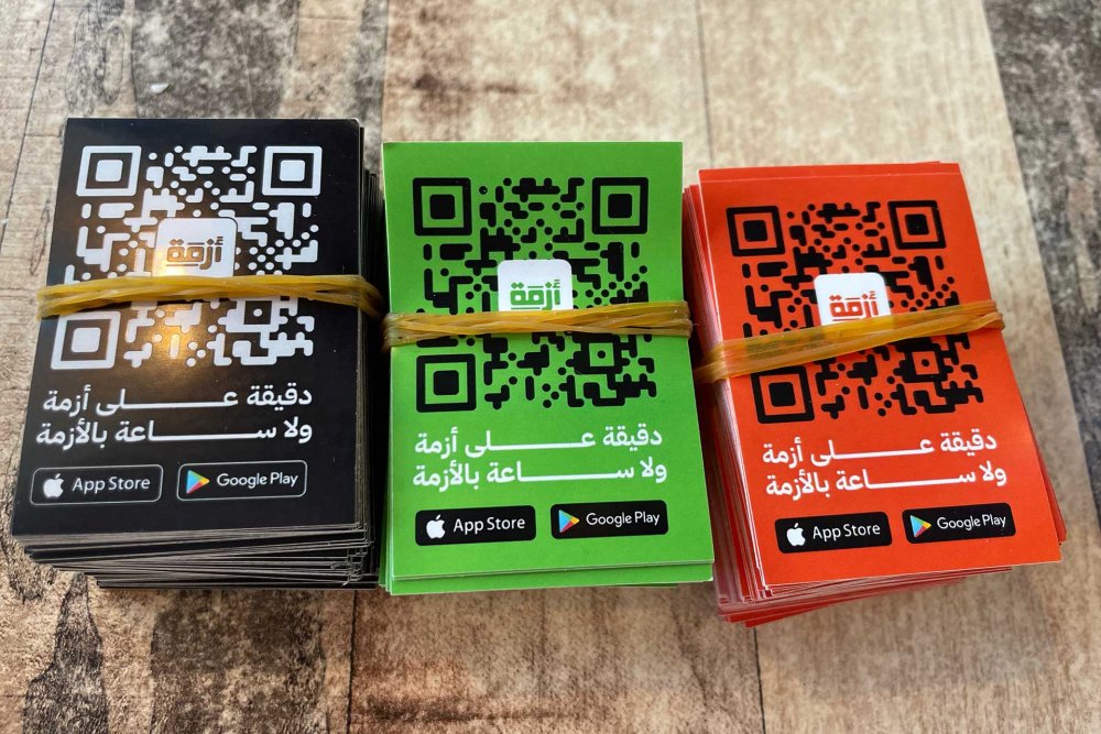
Cards with scannable QR codes to download the Azmeh app

Cards with scannable QR codes for downloading the Azmeh app

Credit: 

Jerusalem Story Team

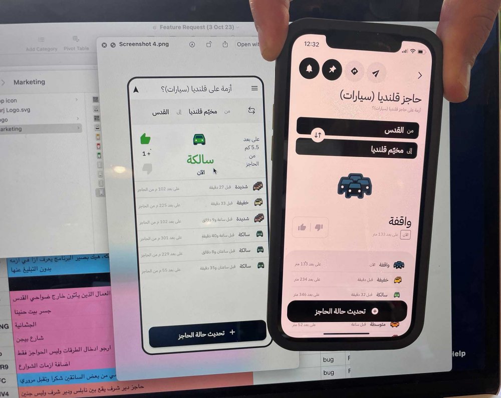
Azmeh is a free application created by local Palestinians, for local Palestinians to help them navigate Israeli checkpoints. It lets users identify the checkpoints that will take them to the desired destination, and users themselves then update the status of the checkpoint in real time—showing whether it’s closed, jammed with traffic, experiencing an incident, or—in the best case—passable.

The creators prefer to remain anonymous, not only for logistical purposes but also because, as they express it, “Our aim isn’t for our app to break records or make us rich or famous; quite the opposite, we want this app not to be needed anymore. The occupation and the checkpoints are the problem.” The Azmeh inventors therefore do not look at themselves as a brand or a product, but rather as a medium created out of sheer necessity. “We are here because we ‘have to’ not because we ‘want to,’” they told Jerusalem Story.

“We want this app not to be needed anymore.”

Azmeh inventors

In Arabic, azmeh means “traffic crisis (jam).” The app was created in 2015, but the developers stopped work on it shortly after, because they received threats by Israeli military personnel who found it suspicious to locate and point out military areas—despite the intention being simply being to share the road conditions. 

Years later, in 2023, a Jerusalem-based Palestinian organization reexamined into the case, and decided to back the app, because it had been so beneficial and helpful for Jerusalemites to use it. Therefore, Azmeh became available again in March 2023.

The icon for the Azmeh app in the App Store

An example of the result a user gets when looking up the status of checkpoints on the Azmeh app

Credit: 

Jerusalem Story Team

Little did anyone know, however, that the need for the Azmeh app would grow so exponentially after October 2023. The war and the consequent high emergency state led the Israeli army to shut down all the roads—confusing all residents about how to go about and around. Thousands upon thousands of students, workers, families, and children needed to get somewhere, for which they resorted to “word of mouth.” At that point, they relied on online sources, such as pages on Facebook, and informal personal groups on WhatsApp, for notifications and updates. Often total strangers would ask each other by phone voice messages and texts about “how the road is,” and they would update one another during their commutes. 

Escalating Demand

In the two months of October and November 2023, an average of 8,000 Palestinians would end up installing the Azmeh app. Every single day. 

Apparently, the number went down to 1,500–2,000 a day in January 2024. Today, about 70,000 installs of the app have been completed since its launch in June 2023.

“We can barely keep up,” said one of the people who manages the app, but noted that this ultimately is “not a good thing.” Yes, the app is doing great—but from their point of view, it’s not okay for Palestinians to need such an app to begin with: The mere existence of these checkpoints—as the digital providers see it—is wrong, so they are not happy about the increase. They are glad they can help, but they believe the need shouldn’t exist in the first place.

“But of course, it’s a need: One could technically get shot if one gets lost at checkpoints or not knowing their ways around checkpoints . . . One mistake could cost you your life,” they shared.

“People have been asking us to add more checkpoints,” they expressed. Initially, they had estimated that the app would include around 200 checkpoints. Little did they know that the number of checkpoints was far higher than anticipated: “Once we reached 100, we thought we were halfway through, but then we realized there are about 750 checkpoints in the West Bank and Jerusalem today . . . And that was before the war. We’re now looking at over 800 checkpoints,” they told Jerusalem Story.

“We’re now looking at over 800 checkpoints.”

An Azmeh app manager

According to UN OCHA, up to early 2023, there were 565 documented movement obstacles in East Jerusalem and the rest of the occupied West Bank. But as of October 2023, new military checkpoints were being erected daily; for example, “Nashash” checkpoint, which Palestinians recently discovered, between Jerusalem and Bethlehem.1

The numbers were rising. Meanwhile, people were hardly keeping up. This was a huge hit for Azmeh.

At the Checkpoints, One Mistake Can Get You Killed

“Not long ago, my brother and I got out of the bus heading from Nablus, because there was too much traffic. We figured we’d cross to the other side by foot,”2 shared Yansoun, a Palestinian Jerusalemite.

“We heard a man screaming out, ‘Hey! Hey!’ behind us. I thought a fight might have been about to break out behind us.

“Normally I’m not curious and would not have bothered to turn around. But the shouting was so loud that I turned around and saw two soldiers who were pointing their riffles at us. They were shouting to us in Hebrew. They were about to shoot us! 

“My brother and I think about this to this day . . . We must have looked so flabbergasted that they did not shoot us. Apparently, we weren’t supposed to walk from there, but we just did not know.”

“They were about to shoot us!”

Yansoun

“Just not knowing” is a mistake that can get one killed. The geography of the checkpoints changes so drastically that if one does not travel frequently, one misses out on a lot. The roads one would have taken to drive from Jerusalem to Ramallah, for example, 10 years ago, are different from the ones one needs to use today. Yes, the path to “Qalandiya” might still be there, but accessing it changes over time. The pedestrian path also changes, without official notices.

One is just “supposed to know.”

“Just not knowing” is a mistake that can get one killed.

Notes

1

Movement and Access in the West Bank | August 2023,” UN OCHA, August 25, 2023.

2

“List of Military Checkpoints in the West Bank and Gaza Strip,” B’Tselem, updated November 11, 2021.

3

Yansoun (pseudonym), interview by Jerusalem Story, February 27, 2024. All subsequent quotes from Yansoun are from this interview.

Load More Load Less