Introduction
Credit:
Ahmad al-Bazz, Activestills
Checkpoints, Part 1: Severing Jerusalem
Snapshot
Palestinians wishing to access Jerusalem must navigate a complex web of Israeli military checkpoints, each with its own different set of rules and designated users. Here we offer a primer on these various checkpoints, which are designed to control and constrict movement of Palestinians to and from Jerusalem and its environs, and which make “moving while Palestinian” a highly complex and profoundly frustrating ordeal.
Part 1 of a two-part series.
The quintessential Palestinian experience, which illustrates some of the most basic issues raised by Palestinian identity, takes place at a border, an airport, a checkpoint: in short, at any one of those many modern barriers where identities are checked and verified . . . For Palestinians, arrival at such barriers generates shared sources of profound anxiety.1
Rashid Khalidi
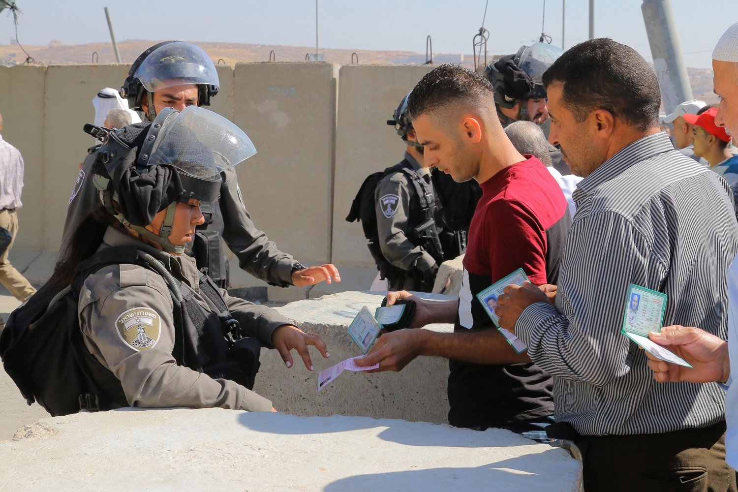
Beginning in March 1993, after the Israeli-imposed closure on the Palestinians of the occupied West Bank and Gaza Strip was announced, Israel started to install seemingly temporary military checkpoints along the Green Line and between East Jerusalem and other parts of the West Bank (see Jerusalem: A Closed City).2 With time, these checkpoints proliferated and went on to become part of a complex and massive system (including the permit regime, the various geopolitical terms of the Oslo Accords, the bypass roads, and the Separation Wall) that has fragmented Palestinian space and time and deprived Palestinians of their freedom of movement3 in a large, militarily occupied area where Israeli citizens remain outside said system and retain complete freedom of movement and all their legal and political rights under Israeli civil law (see Closure and the Dismemberment of Jerusalem).
By 2020, according to United Nations Office for the Coordination of Humanitarian Affairs (UN-OCHA) data,4 as of June 2020, throughout the occupied West Bank, there were 179 fully staffed or occasionally staffed checkpoints, in addition to 154 road gates, 68 roadblocks, and 371 other kinds of movement obstacles set in the face of Palestinians.5 This does not include the 84 agricultural gates in the Separation Wall that restrict Palestinians from accessing their agricultural lands, the absolute majority of which are only seasonally opened and for a brief amount of time during the day6 (see Al-Jidar: An Instrument of Fragmentation).
In addition, thousands of temporary checkpoints are set in place spontaneously by the Israeli army across West Bank roads each year (commonly referred to as “flying checkpoints”). Between April 2019 and March 2020, Israeli forces deployed more than 1,500 flying checkpoints across the West Bank.7 Between January 2017 and August 2018, Israeli forces deployed about 4,924 flying checkpoints across the West Bank.8
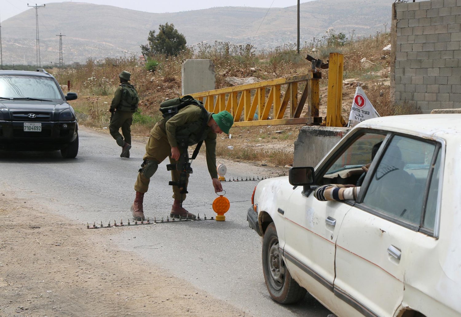
A flying checkpoint positioned at Beit Furik, near Nablus, May 27, 2015
Credit:
Ahmad al-Bazz, Activestills
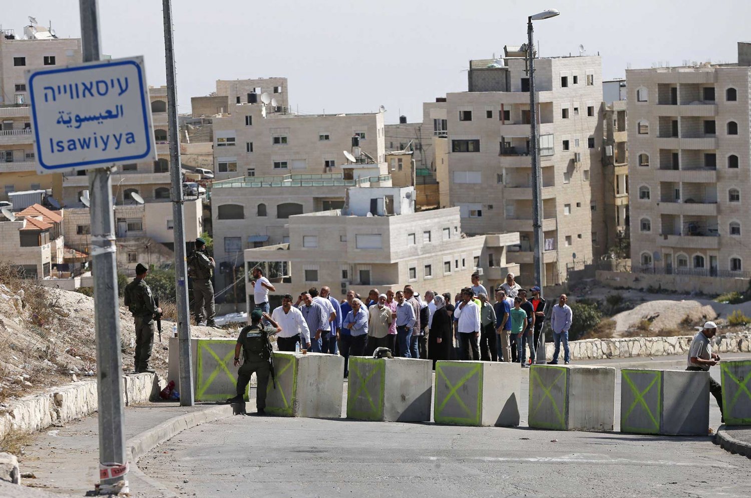
Palestinians returning home wait to enter al-‘Isawiyya after police set up a flying checkpoint in East Jerusalem on October 15, 2016, in the midst of a wave of knifings in the city.
Credit:
Ammar Awad, Reuters via Alamy Stock Photo
Checkpoints in the occupied territories are not exceptional in the Israeli-Palestinian encounter; Israel imposed them on Palestinian communities elsewhere throughout the years since the state’s founding. For example, in September 1948, the few Palestinians remaining in what became West Jerusalem were corralled into a fenced-in zone, called Zone A, in the al-Baq‘a neighborhood of the New City and forced to remain in it without freedom of mobility or access to the rest of the city or their homes for over a year (see The West Side Story).9 Inside the rest of the land that became Israel after 1948, a military rule was imposed on Palestinians who were citizens until 1966; it derived from the emergency regulations that had been in force under the British Mandate. “The main use of these regulations was to reduce these citizens’ freedom of movement. Palestinian Arab population centres were declared military zones: their residents could not exit them without a permit from the local military commander.”
Indeed, checkpoints have become so ubiquitous and central to Palestinian experience that Palestinian intellectual, political writer, and former MK Azmi Bishara wrote a book about them in 2004 in which he referred to the occupied territories as “the land of the checkpoints,” the Israelis as “the owners of the checkpoints,” and the Palestinians as “the people of the land of the checkpoints.”10
This Backgrounder provides a brief introductory overview of the permanent checkpoints around Jerusalem today. Part 2 examines the complexities of navigating the checkpoints for Palestinians.
For more background and historical context on checkpoints, closure, and the permit regime, see Closure and Access to Jerusalem. For in-depth coverage of the Separation Wall, see The Separation Wall.
Personal Story
The Baq‘a Zone Ghetto: A Memoir of a Palestinian Jerusalemite Who Remained in West Jerusalem after the War
Jacob Nammar, whose family established the al-Nammamreh neighborhood in al-Baq‘a, shares the trauma his family went through in what became West Jerusalem.
Checkpoints around Jerusalem
Among the numerous checkpoints, 39 are defined as “points of entry into Israel” or “final checkpoint before Israel.” In Israeli parlance, this means that they sit on the boundary point where the territory becomes Israel. While under international law this would mean Israel within its 1948 boundaries (i.e., on the 1949 Green Line), in fact, most of these “entry” checkpoints are not placed on the Green Line at all but rather within—and sometimes deep within—the territory of the occupied West Bank.11
Some of the checkpoints currently positioned around Jerusalem date back to the 1990s. However, most of them were installed in the fall of 2000 and the commencement of construction of the Separation Wall in 2002.12
As far as Jerusalem is concerned, there are 18 checkpoints directly surrounding the city:
- 13 are checkpoints controlling entry into Israeli-controlled East Jerusalem.
- 5 are located between Palestinian localities in the West-Bank around Jerusalem.
Note that five additional checkpoints lie just beyond the city to the south. While these are beyond the scope of this Backgrounder, they can be found on Map 1, and they generally control (or prevent) Palestinian access to the “Gush Etzion” bloc of Israeli settlements in the south.
Each of these 18 checkpoints has its particular designations and allowed crossers, as detailed in Table 1.
Of the 13 checkpoints controlling entry into East Jerusalem, some are designated for the passage of people only and must be crossed on foot; others are only for commercial goods (e.g., Beituniya commercial checkpoint north of Jerusalem) and require a switch of vehicle using back-to-back unloading of goods, because cars with Palestinian Authority (West Bank) license plates are not allowed to enter Israel. Some checkpoints are only for those (whether Israelis or Palestinians) holding Israeli identification cards (e.g., Hizma checkpoint northeast of Jerusalem); at certain of these checkpoints, yellow-plated vehicles are allowed to drive through.
Others can be crossed only by Palestinians whose names are registered on a list on file (and continually updated) at the checkpoint (e.g., al-Sawahira al-Sharqiyya checkpoint).
Some, while located far beyond Israeli municipal boundaries, are placed on Israeli-only roads that lead to Jerusalem (e.g., the Ofer-Jerusalem checkpoint). Only one, the al-Walaja checkpoint, is actually located on the Green Line.
The five checkpoints around Jerusalem monitor and control access around the Jerusalem area. Some are placed between Palestinian villages, towns, and neighborhoods, such that one side is found within the vicinity of an Israeli settlement enclave on the West Bank side of the Separation Wall (e.g., Biddu/Beit Iksa checkpoint northeast of Jerusalem); others are found on Palestinian roads that pass through settlement-controlled areas (e.g., the Container/Wadi al-Nar checkpoint southeast of Jerusalem).
Qalandiya
The largest checkpoint is Qalandiya, north of Jerusalem, which controls all entry coming into Jerusalem from the north (Ramallah and beyond to the rest of the West Bank). It is one of only three checkpoints that Palestinians with PA ID cards are allowed to use (see Table 1), and the only one on the northern edge of Jerusalem. Today, more than 25,000 Palestinians pass through the Qalandiya checkpoint each day, and the checkpoint handles a third of daily Palestinian movements in and out of the West Bank.13
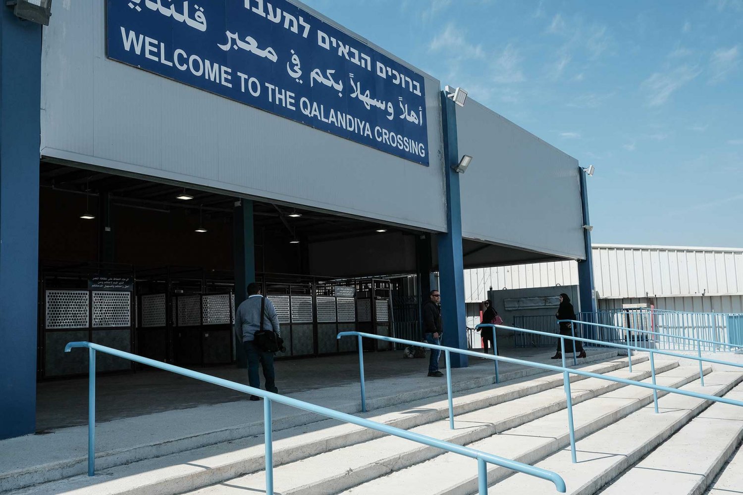
Front entrance of the new Qalandiya checkpoint, now rebranded as a “crossing,” March 28, 2109
Credit:
Nir Alon, Alamy Stock Photo
Checkpoint 300
The other major checkpoint controlling access to Jerusalem is Checkpoint 300 in the south, which separates Bethlehem and Jerusalem. Checkpoint 300 is the second of the three checkpoints that PA ID cardholders are allowed to use. Like Qalandiya, Checkpoint 300 started out in the 1990s “as a combination of cement blocks, sand bags, and Israeli soldiers, with the aim of checking the documents of Palestinians travelling to Jerusalem and further on.”14 Today, about 15,000 Palestinians pass through this checkpoint on foot each day.15
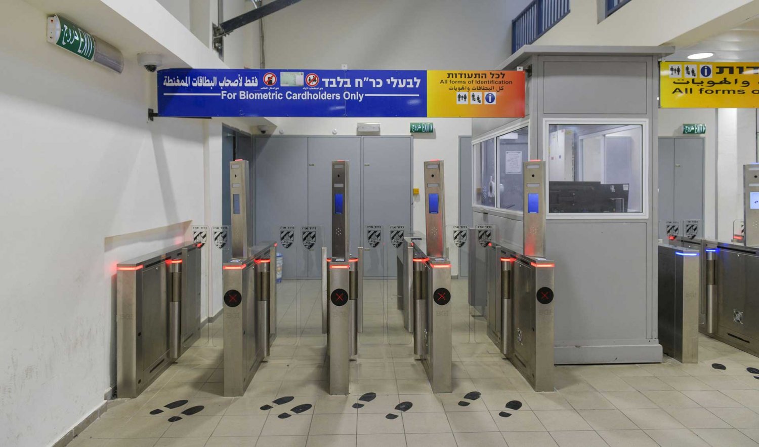
The new “modernized” turnstiles recently installed at Checkpoint 300. As announced on the sign, passers-through are required to present a biometric card sharing their biodata and to undergo other scans such as facial and fingerprints as they move through. In this way, the state compiles a massive database on Palestinians even as they commute to work.
Credit:
Alamy
Al-Zaytun/Ras Abu Sbitan
The third checkpoint that PA ID cardholders are allowed to use is al-Zaytun/Ras Abu Sbitan in the east, separating al-‘Izariyya from East Jerusalem.
Language Chasm
The namings of these checkpoints varies widely between Israelis and Palestinians. Israelis generally use the Hebrew term ma’var, which means “crossing,” while Palestinians use the Arabic word for checkpoint (hajiz), which indicates separation of one side from another, rather than the term crossing (ma‘bar), which connotes mere routine crossing from one side to the other. Also, hajiz holds the connotation of blocking someone’s regular way.
But the language sanitizing has gone even further—now the “crossings” have been elevated to “border crossings” and “international terminals” in Israeli discourse, as part of a massive effort to rebrand the occupation as a “humanitarian” effort offering a “modernized,” “efficient,” and highly “professional” experience.16
The checkpoints around Jerusalem are mainly run by “Crossing Departments” of the Israeli Police or by the Israeli Border Police.17 The policemen are accompanied by civilian guards employed by private security companies.18
In 2019, Israel unveiled new “terminals” for these checkpoints designed to resemble airports and thus to give an impression of normalcy at an “international border.” But these checkpoints are surveillance tools that are located mostly within the land of the occupied West Bank itself, and not on any kind of international border. They are part of a system of military occupation that deprives an entire, largely stateless population of freedom of movement, not an international system that exists within a framework of international law for citizens of different countries. They are a system imposed by force on a population that is completely under the control of the state, with no right to reject or appeal its suffocation of their lives.
No matter how apparently “upgraded” the checkpoints may appear to be or how sanitized is the language used to explain them to the world, the reality is that the closure and permit regimes that underpin these checkpoints remain in full force, with all the consequent violations of basic humans rights that derive from them (see Closure and Access to Jerusalem).
More notable than the appearance of “normalcy” is the clear entrenched permanence that construction of such a major apparatus of movement control, along with the Separation Wall in which they are embedded, implies. To the state, this system is here to stay. To the Palestinians, this means their right to freedom of movement is denied indefinitely.
The Checkpoints
Map 1 locates the military checkpoints around Jerusalem. Table 1 details more about how the checkpoints control Palestinian entry into and movement around Jerusalem, and how Palestinians must navigate a labyrinth of complex regulations that govern who can or must use specific checkpoints, how they must come prepared, and when the checkpoint may or may not be open. Checkpoints are listed in clockwise order as they occur in the map.
It is important to underline the fact that this checkpoint system is for Palestinians only. Jews, whether they live in Jerusalem or in settlements around Jerusalem, enter the city by passing through a vehicular checkpoint that offers them an experience similar to passing through a tollbooth (see Closure and the Dismemberment of Jerusalem).
Table 1: Israeli checkpoints controlling Palestinian entry into Jerusalem and movement around Jerusalem
| Name | Function | Location | Type | Staffing and hours of operation | Details (allowed use) |
|---|---|---|---|---|---|
| Qalandiya | Checkpoint in the Separation Wall between the Ramallah region and Jerusalem separating Qalandiya refugee camp and Kufr ‘Aqab that are within the Israeli municipal boundaries from the rest of the city | At the northeastern edge of Jerusalem | Final checkpoint before Jerusalem Has extensive infrastructure and is defined as a terminal |
Permanently staffed by the military and private security companies Open 24-7 |
Palestinians holding PA ID cards and valid Israeli entry permits, subject to inspection Palestinians holding Israeli IDs (including permanent-resident IDs, i.e., Jerusalemites) Accommodates pedestrians and drivers (cars and busses) PA ID cardholders must pass it on foot; Israeli ID cardholders can drive through in yellow-plated cars. Not used by Jewish settlers |
| Jaba‘/al-Ram | Located on the road between al-Ram and Jaba‘ in the vicinity of the Kochav Ya’acov settlement | Outside the northeastern edge of the of Jerusalem boundary | Checkpoint in the West Bank around Jerusalem | Intermittently staffed by the military | Passengers travelling to Ramallah are checked; passengers from Ramallah are occasionally checked. |
| Hizma | Checkpoint in the Separation Wall at the southwestern edge of Hizma, a village that is largely (but not entirely) on the “other” side of the wall on land that has been designated Area B, with small parts on Area B and within the municipal boundaries Separates Palestinian villages east of Jerusalem, like Hizma and ‘Anata, from the center of the city East of the Israeli settlement of Pisgat Ze’ev |
In Separation Wall inside the eastern boundaries of Jerusalem On Route 4370 otherwise known as the “Apartheid Road,” because it segregates Israeli and Palestinian cars, with Palestinians having no access to enter Jerusalem from their side, unlike Israelis); connects with Route 1 in East Jerusalem |
Final checkpoint before Jerusalem | Permanently staffed by Border Police and private security companies | Closed to Palestinians, with the exception of holders of Israeli permanent-resident IDs and members of the Khatib and 'Askar families. These families are from the West Bank village of Hizma and they hold PA IDs, but the wall separated their homes (which are on the Jerusalem side of the wall) from their village (which is on the West Bank side of the wall). Their access to the “Jerusalem side” of the wall is limited only to their own homes, no farther into the city. This means they cross the wall daily to go from their homes to their village and back. Vehicles (yellow-plated) only; Palestinian busses can pass through subject to a security search of every passenger’s documents Used by Israelis to reach the settlements |
| Shu‘fat refugee camp | Checkpoint in the Separation Wall located at the entrance to the Shu‘fat refugee camp and separating it along with ‘Anata, which are both inside the Israeli municipal boundaries, from the rest of the city | In Separation Wall inside the eastern boundaries of Jerusalem | Final checkpoint before Jerusalem Expanded into a terminal in 2011 |
Permanently staffed by Border Police and private security companies Open 24-7 |
Used by residents of Shu‘fat refugee camp and the neighborhood of Ras Khamis* to enter East Jerusalem Other holders of Israeli IDs and residents of ‘Anata who hold entry permits to Israel may also go through. Closed to all other Palestinians |
| ‘Anata/al-‘Isawiyya (Opened in late 2018) |
Checkpoint between ‘Anata and al-‘Isawiyya Located on the Eastern Ring Road (4370), connects with Route 1 in East Jerusalem |
On eastern edge of Jerusalem | Final checkpoint before Jerusalem | Staffed by Border Police Open 5:30 a.m. to noon; closed thereafter |
Closed to all Palestinians except for those with Israeli permanent-resident IDs |
| al-Za‘ayim | Checkpoint in the Separation Wall, separating al-Za‘ayim from Jerusalem Located on Route 1 toward Ma‘ale Adumim settlement |
East of Jerusalem, on or near Route 1 | Final checkpoint before Jerusalem Transfer point for goods Palestinian localities in the West Bank around Jerusalem |
Permanently staffed by Border Police and private security companies Open 24-7 |
Palestinians are not permitted to cross here except for holders of Israeli permanent-resident IDs in vehicles (no pedestrian crossing). |
| al-Zaytun/Ras Abu Sbitan | Checkpoint in the Separation Wall, separating al-‘Izariyya from the neighborhood of al-Tur and the rest of East Jerusalem | East of Jerusalem | Final checkpoint before Jerusalem | Permanently staffed by Border Police and private security companies Open 24-7 |
Closed to Palestinians except holders of Israeli permanent-resident IDs or PA IDs with valid entry permits; the latter are allowed to cross only on foot. |
| al-Sawahira al-Sharqiyya | Checkpoint in Separation Wall that separates the Palestinian villages of al-Sawahira al-Sharqiyya from al-Sawahira al-Gharbiyya (including Jabal Mukabbir) and from the rest of East Jerusalem | On Separation Wall inside the southeastern boundary of Jerusalem | Final checkpoint before Jerusalem | Permanently staffed by Border Police and private security companies Open 24-7 |
Closed to Palestinians except:
|
| Container/Wadi al-Nar | Checkpoint located on the Wadi al-Nar road that connects Bethlehem to the East Jerusalem suburbs and to Ramallah | Southeast of Jerusalem | Checkpoint in the West Bank around Jerusalem | Permanently staffed by the military Open 24-7 |
Controls Palestinian travel between the northern and southern West Bank; includes traffic lanes, access roads, road spikes, traffic lights, and road signs Used daily by Palestinians in al-Sawahira al-Sharqiyya, Abu Dis, and al-‘Izariyya |
| Sheikh Sa‘d | Checkpoint in the Separation Wall, at the entrance to Sheikh Sa‘d, dividing it from Jabal Mukkabir (a neighborhood of Shiekh Sa‘d) | On southeastern edge of Jerusalem | Final checkpoint before Jerusalem | Permanently staffed | Pedestrian traffic only Closed to Palestinians, except:
|
| al-Nu‘man/Mazmuriyya | Checkpoint between the northeast of Bethlehem and the southeast of Jerusalem disconnecting Sur Bahir, Umm Tuba, and the small village of al-Nu‘man from the Palestinian localities to the east | Southeast of Jerusalem | Final checkpoint before Jerusalem | Permanently staffed by Border Police and private security companies Open 24-7 |
Closed to Palestinians, with the exception of residents of Mazmuriyya and holders of Israeli IDs Open to Jewish settlers |
| Checkpoint 300 | Checkpoint in the Separation Wall between Jerusalem and Bethlehem | On southern boundary of Jerusalem | Final checkpoint before Jerusalem Has an extensive infrastructure and is defined as a terminal |
Permanently staffed by the military, Border Police, and private security companies Open 24-7 |
Palestinians holding PA ID cards and valid Israeli entry permits, subject to inspection Palestinians holding Israeli IDs (including permanent-resident IDs, i.e., Jerusalemites) Accommodates pedestrians and drivers (cars and busses) The checkpoint has a car lane, but only those with foreign passports or Israeli IDs can use it and only in yellow-plated (Israeli) cars. All others, including all Palestinian PA ID holders, can only cross on foot. As it leads from Area C to Area A, Israeli Jewish citizens do not use it. Israeli tourist buses are allowed to enter Bethlehem only through this crossing. |
| Beit Jala Tunnels | Road Checkpoint located on Route 60 between the Bethlehem region and Jerusalem connecting settlements south of Jerusalem to the city | In the West Bank, south of Jerusalem Located on Route 60 west of the entrance to Beit Jala |
Final checkpoint before Jerusalem | Permanently staffed by the military, Border Police, and private security companies | Can only be passed through with a vehicle Similar to a tollbooth, but staffed by soldiers or private security personnel; watchtower nearby with area for security checks of vehicles 4 lanes lead to Jerusalem; 2 lanes lead in the opposite direction, to Bethlehem/Hebron Closed to Palestinians except holders of foreign passports or Israeli IDs in yellow-plated cars Commonly used by Jewish settlers driving to Jerusalem from the south Palestinians with PA IDs and valid entry permits can cross this checkpoint in a Palestinian bus, but their documents are always checked before the bus is allowed to proceed. |
| al-Walaja | Checkpoint located on the Green Line on a road leading to East Jerusalem The only checkpoint that is actually on the Green Line |
In southwestern Jerusalem | Final checkpoint before Jerusalem | Permanently staffed by the military, Border Police, and private security companies | Can only be passed through with a vehicle Similar to a tollbooth, but staffed by soldiers or private security personnel Smaller vehicular checkpoint; only 1 lane in either direction Closed to Palestinians except holders of foreign passports or Israeli IDs in yellow-plated cars Commonly used by Jewish settlers driving to Jerusalem from the south |
| Beit Iksa/Biddu | Checkpoint in the Separation Wall, separating the West Bank Palestinian village of Beit Iksa from the West Bank village of Biddu | Northwest of Jerusalem | Checkpoint in the West Bank around Jerusalem | Permanently staffed by Border Police and private security companies Open 24-7 |
Beit Iksa is a West Bank Palestinian village which has an exceptional status in that it is surrounded on three sides by the Separation Wall, but its eastern side was left open to Israel and faces the Israeli neighborhood of Ramot. Because it is an area falling within the PA’s jurisdiction but with open exposure to an area of Israeli municipal Jerusalem, the only people allowed to enter the village through this checkpoint are registered villagers and internationals.[3] Passage is permitted to all Beit Iksa residents, some Biddu residents, and holders of Israeli permanent-resident IDs only. (See The Suffocation of Beit Iksa, al-Nabi Samwil, and al-Khalayla) |
| Giv‘at Ze’ev/al-Jib | Checkpoint in the Separation Wall, placed on the western end of the Palestinian village of al-Jib, leaving its neighborhood of al-Khalaya on the other side within the Giv‘at Ze’ev settlement enclave | Northwest of Jerusalem | Checkpoint in the West Bank around Jerusalem | Permanently staffed by Border Police and private security companies | Closed to Palestinians entering from the east, except:
As of February 2015, Palestinian holders of Israeli permanent-resident IDs are permitted to cross from this point into Ramallah, but not the reverse direction. |
| Ofer-Jerusalem | Located on the Israeli-only Road 443 north of Jerusalem within the Giv‘at Ze’ev enclave | North of Jerusalem | Final checkpoint before Jerusalem | Permanently staffed by the military and private security companies Open 24-7 |
Closed to Palestinians, with the exception of East Jerusalem residents |
| Beituniya commercial crossing | Checkpoint in the Separation Wall between the Beituniya and the Giv‘at Ze’ev settlement enclave north of Jerusalem; located on Street 436, which is restricted to Israeli cars only | North of Jerusalem | Final checkpoint before Jerusalem | Open from 6:00 a.m. to 6:00 p.m. | Used only for trucks transporting goods from and to Ramallah, using the “back-to-back” method between the West Bank and Israel |
[1] Adapted from “List of Military Checkpoints in the West Bank and Gaza,” B’Tselem, last modified September 25, 2019, with additional information from Rijke, “The Land of the Checkpoints,” chapter 1, “Introduction,” 3–27.
*Referred to by Israelis in Hebrew as “Atarot” checkpoint.
**“Isolated: Israel Cuts Off Village of Beit Iksa from East Jerusalem and the Rest of the West Bank,” B’Tselem, August 17, 2016.
*** The Ras Khamis checkpoint, which was used for the same purpose, was closed in September 2012.
Notes
1
Rashid Khalidi, Palestinian Identity: The Construction of Modern National Consciousness (New York: Columbia University Press, 2010).
3
Amira Hass, “Israel’s Closure Policy: An Ineffective Strategy of Containment and Repression,” Journal of Palestine Studies 31, no. 3 (2002): 5–20.
4
UNOCHA, “West Bank Access Restrictions,” United Nations Office for the Coordination of Humanitarian Affairs, June 2020.
5
86 earth mounds, 20 earth walls, 3 trenches, 49 road barriers, and 34 other kinds of barriers like barbed wire, irons gates, etc. UNOCHA, “West Bank Access Restrictions.”
6
UNOCHA, “Increased Restrictions on Access to Agricultural Land behind the Barrier,” May 25, 2017.
8
UNOCHA, “Over 700 Road Obstacles Control Palestinian Movement within the West Bank,” October 8, 2018.
9
Issam Nassar, “Partitioned Jerusalem: The Fate of the Palestinians Who Remained in West Jerusalem,” Middle East Insights, no. 226 (2020).
10
Azmi Bishara, Checkpoint (Actes Sud, 2004), as cited in Irus Braverman, “A Study of Israel’s New Crossing Administration,” Antipode: A Radical Journal of Geography 43, no. 2 (2011): 264.
11
“Restrictions on Movement,” B’Tselem, November 11, 2017.
12
“The Separation Barrier: Position Barrier,” B’Tselem, September 2002, 5.
13
Miriam Berger, “Israel’s ‘Checkpoint Q’: A Daily Hurdle for Palestinians,” Reuters, April 26, 2017.
14
Alexandra Rijke, “The Land of the Checkpoints: A Study of the Daily Geographies of Checkpoints in the Occupied Palestinian Territories” (PhD thesis, Wageningen University, 2019).
15
“Israel’s Military Checkpoints,” Al Jazeera, accessed August 16, 2010.
16
Braverman, “A Study,” 265–66.
17
“List of Military Checkpoints in the West Bank and Gaza,” B’Tselem, last modified September 25, 2019.
18
Shira Habkin, “Checkpoints Privatization in the West Bank and Gaza” [in Hebrew] (Jerusalem: Van Leer Institute, February 2014).