View of al-‘Isawiyya, a Palestinian neighborhood under the Hebrew University of Jerusalem

Credit:

Hagai Agmon-Snir via Wikipedia (CC BY-SA 4.0)

Feature Story

The City Advances Plan to Confiscate Palestinian Land between al-‘Isawiyya and al-Tur for National Park

Snapshot

The Jerusalem Municipality is advancing zoning plans to turn Palestinian land between the neighborhoods of al-‘Isawiyya and al-Tur into a national park. Jerusalem Story spoke with objectors to the plan to learn more.

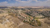
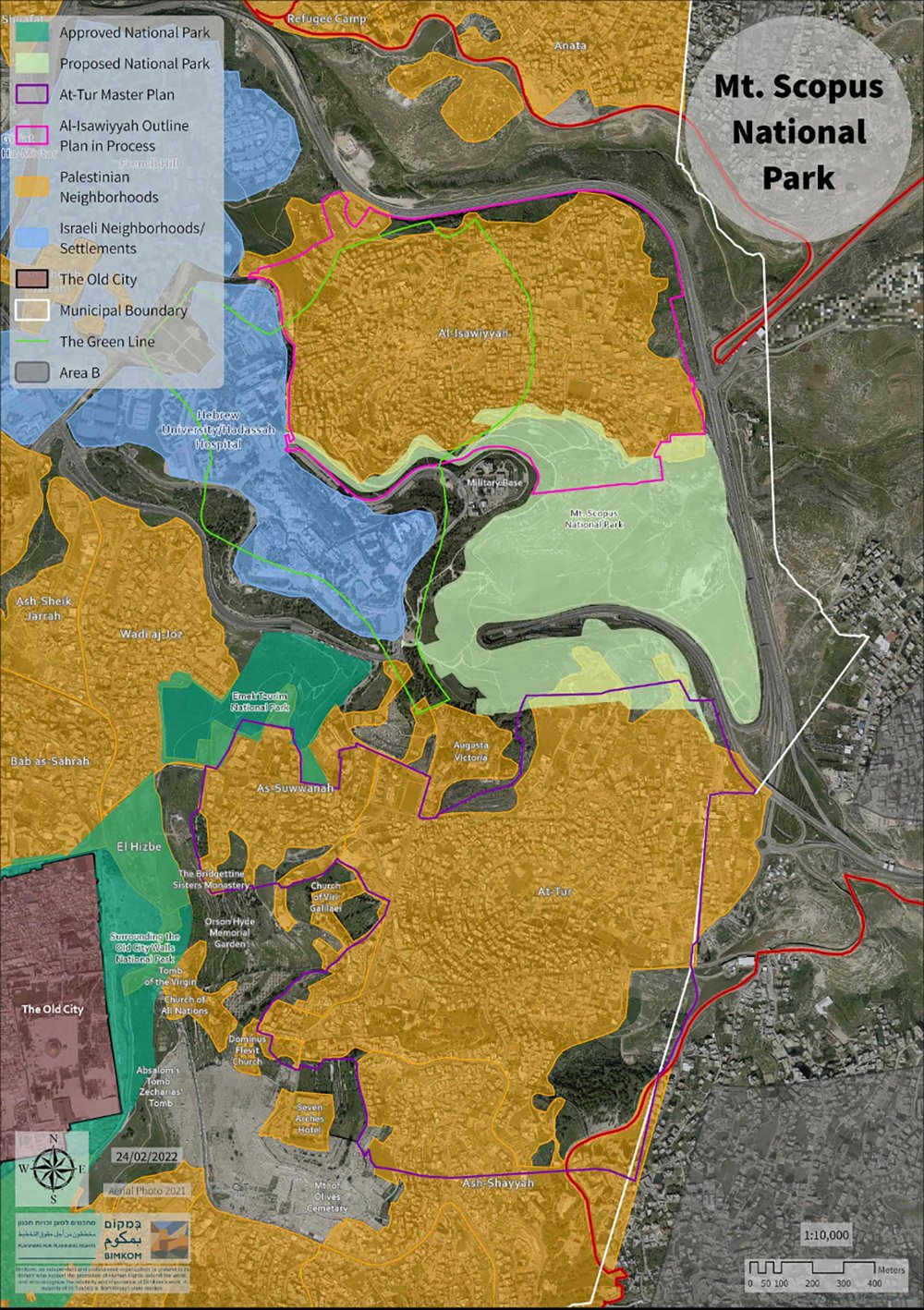
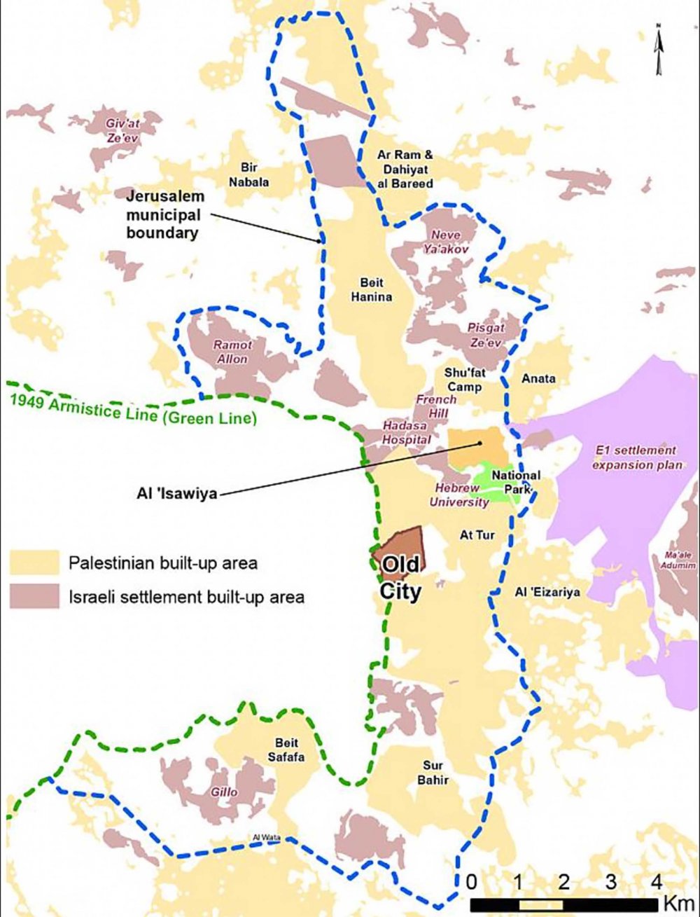
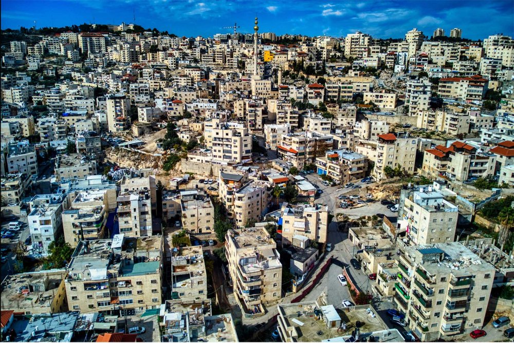
On March 5, 2024, the Jerusalem Municipality’s District Planning Committee held a hearing on objections filed against the Mount Scopus Slopes National Park plan (TPS 1195114). The plan seeks to designate the land between the Palestinian neighborhoods of al-‘Isawiyya and al-Tur in occupied East Jerusalem as a national park,1 which means Palestinians in these neighborhoods would be barred from any further construction in the area.

According to Bimkom, an Israeli planning rights organization and one of the main parties filing an objection to the plan, the planning committee could take weeks to release its decision on whether to approve or reject the plan based on these objections.

“Most of the point of these plans is to create facts on the ground and make sure the land isn’t built on by landowners for housing purposes. So, it’s more of a land grab,” Sari Kronish, an architect at Bimkom, explained.2

Feature Story Delayed but Not Dead, the E1 Settlement Plan Threatens Lingering Two-State Dreams

The international community has managed to delay the E1 settlement plan once again, but it is only a matter of time until Israel puts it back on the table.

A map illustrating the site of the proposed Mount Scopus National Park, shown in the center in bright yellow

A map illustrating the site of the proposed Mount Scopus National Park, shown in the center in bright yellow. To the north of the area is al-‘Isawiyya, and to the south is al-Tur, both in orange. The eastern quadrant of the Old City is visible in the bottom left in purple.

Credit: 

Bimkom via Ir Amim

The March hearing considered the second round of objections to the plan, which were filed during wartime in November 2023. “I find it important to highlight that these things don’t get stopped during wartime, but get accelerated and pushed forward,” Kronish added.

“Most of the point of these plans is to create facts on the ground and make sure the land isn’t built on by landowners for housing purposes.”

Sari Kronish, architect, Bimkom

Israel has long weaponized so-called green space as a tool for displacement. Often, the Israel Nature and Parks Authority (INPA) declares open areas as national parks or reserves citing conservation purposes, whereas the real reason is to solidify Israeli claims to the land and prevent Palestinian building.

More than a decade ago, the INPA initiated the plan to turn the vacant space sandwiched between al-‘Isawiyya and al-Tur into a national park, encompassing the land east of the Hebrew University of Jerusalem toward the E1 Development Plan3 (short for “East 1,” the Israeli designation for the land east of Jerusalem in the occupied West Bank). The park’s boundaries disrupt any possibility of establishing a continuous Palestinian state in the West Bank with East Jerusalem as its capital by cementing Israeli control between East Jerusalem and the E1 developments, effectively bifurcating the Palestinian populated West Bank in half.

“Israel doesn’t want Palestinian neighborhoods to grow,” Hani Issawi, a resident of al-‘Isawiyya who is involved in Bimkom’s petition against the plan, explained.4 “The main aim isn’t to make a park. It’s to keep this area empty and join the area planned for E1 with Jerusalem, so Palestinian neighborhoods can’t expand and merge.”

According to Bimkom and Jerusalem-focused rights group Ir Amim,5 the plan came as a response to the attempts of Palestinian residents of al-‘Isawiyya and al-Tur to establish a zoning plan for their neighborhoods in the mid-2000s in order to stop home demolitions and expand their neighborhoods.

A woman tends to sheep next to a house demolished in a Jahalin Bedouin community within the E1 Development Plan, January 2015.
Feature Story Israel Takes Final Steps to Large-Scale Land Confiscation and Forced Displacement of Bedouin

Three Bedouin communities face one more effort to displace them as Israel confiscates Palestinian land.

“I find it important to highlight that these things don’t get stopped during wartime, but get accelerated and pushed forward.”

Sari Kronish, architect, Bimkom

“Both of these neighborhoods were trying to promote more adequate planning for their neighborhoods. And in response, rather than helping them promote adequate planning, the authorities said, ‘We’re actually working on a national park, so you can’t plan here,’” Kronish said.

The residents were advancing their zoning plans as part of the Jerusalem 2000 outline plan for the city, which has yet to be approved. Rights organizations assert6 that Israeli planning authorities use the unauthorized Jerusalem 2000 plan as a way to dictate policy when it comes to building procedures—often to the detriment of Palestinian neighborhoods.

A map showing the city’s proposed national park in green in relation to al-‘Isawiyya, al-Tur, and East Jerusalem as a whole

A map showing the location of the proposed national park in green in relation to al-‘Isawiyya, al-Tur, and broader East Jerusalem. The E1 Development Plan is seen on the right in purple, as are the Israeli developments of French Hill, Hadassah Hospital, and Hebrew University surrounding al-‘Isawiyya.

Credit: 

UN OCHA via Wikipedia (CC BY-SA 4.0)

While the Mount Scopus Slopes National Park plan was halted in 2014 to address the development needs of the nearby neighborhoods, it resurfaced in 2022 with amended borders. The Jerusalem District Planning Committee cited the recently approved outline plan for al-‘Isawiyya and the proposed outline plan for al-Tur as meeting the communities’ needs.

Yet the new lines drawn still don’t solve major developmental problems for Palestinians in these neighborhoods, including the difficulty of receiving building permits, proving ownership, and reducing the effects of decades-long urban planning discrimination.

“In al-‘Isawiyya, the situation is complicated for us,” Issawi said. “To prove ownership, we have to get a certificate from Beit El, from the security commander at the Civil Administration in the West Bank, because there is no tabu in al-‘Isawiyya.” As with building permits, Palestinians often are not granted these certificates, Issawi explained.

“Israel doesn’t want Palestinian neighborhoods to grow.”

Hani Issawi, resident, al-‘Isawiyya

“From a planning point of view, these neighborhoods are slums,” Kronish explained. “You can’t do slum improvement without allowing them to grow.”

The proposed outline plan also prevents developing an access road for al-Tur; slates about 10 structures (including homes) for demolition; and calls for expropriating the designated national park area. Though legal in Israeli law, this is not required nor normally done for national parks.7

“Residents of both neighborhoods want open space, but certainly not a national park that’s the size of the neighborhood and clearly intended to limit the growth of the neighborhood,” Kronish asserted. “This means less housing units for Palestinians, and it’s all part of the demographic play in Jerusalem.”

The expropriation directive was of particular concern during the recent objection hearing, Kronish noted. “With a lot of the objections, the motivation is to make sure that the expropriation at least doesn’t take place,” Kronish said. “We are pretty sure the district planning committee is not going to shelve the plan now, but these are the types of demands that they can accept.”

Neither the INPA nor the Jerusalem Municipality responded to Jerusalem Story’s inquiries on the revised plan’s borders.

al-‘Isawiyya, center left, in 1937, with the Hebrew University of Jerusalem visible in the foreground

An aerial photo of al-‘Isawiyya, center left, in 1937, with the Hebrew University of Jerusalem visible in the foreground

Credit: 

Zoltan Kluger via Wikipedia (Public Domain)

Issawi said the current outline plan only allocates 950 dunams for al-‘Isawiyya, which cannot accommodate the neighborhood’s approximately 22,000 residents.8 Originally, the municipality’s proposed plan in the 1980s allocated 666 dunams for al-‘Isawiyya’s then 8,000 residents. The population has nearly tripled since, but the area earmarked for the neighborhood has not.

The silhouettes of former homes are regular fixtures throughout the crowded streets of al-‘Isawiyya. According to Issawi, 12 structures have been demolished in the last two years—with the majority of buildings razed because they were built outside the borders of the current outline plan. Some of these buildings have been demolished multiple times.

“The people here, they have no choice. They have to build and to live. There is no place,” Issawi said.

“In al-‘Isawiyya, we are like an island between Jewish settlements and projects.”

Hani Issawi, resident, al-‘Isawiyya

An aerial view of al-‘Isawiyya in 2022

An aerial view of al-‘Isawiyya in 2022

Credit: 

Hagai Agmon-Snir via Wikipedia (CC BY-SA 4.0)

Stuck between the Israeli settlement of French Hill, Israel’s Hadassah Hospital, and the Hebrew University of Jerusalem, Issawi said there’s no room to expand. The road leading to the Israeli settlement of Ma‘ale Adumim in the West Bank also bisects the neighborhood.

“In al-‘Isawiyya, we are like an island between Jewish settlements and projects,” Issawi said. “We asked them to give us only the lands in between these projects, but we didn’t succeed.”

Notes

2

Sari Kronish, interview by the author, March 6, 2024. All subsequent quotes from Kronish are from this interview.

4

Hani Issawi, interview by the author, March 20, 2024. All subsequent quotes from Issawi are from this interview.

5

Ir Amim and Bimkom, “Renewed Attempt to Promote Mount Scopus Slopes National Park Plan,” February 28, 2022.

6

Panel Unlawfully Using Outline Plan for Jerusalem,” Association for Civil Rights in Israel, updated October 1, 2013.

7

Ir Amim and Bimkom, “As Mt Scopus Slopes.

Load More Load Less