Protesters demonstrate the threatened expulsion of Palestinians in Sheikh Jarrah, East Jerusalem

Credit: 

Ahmad Gharabli

New Digital Mapping Platform Shares Sheikh Jarrah’s Story with the World

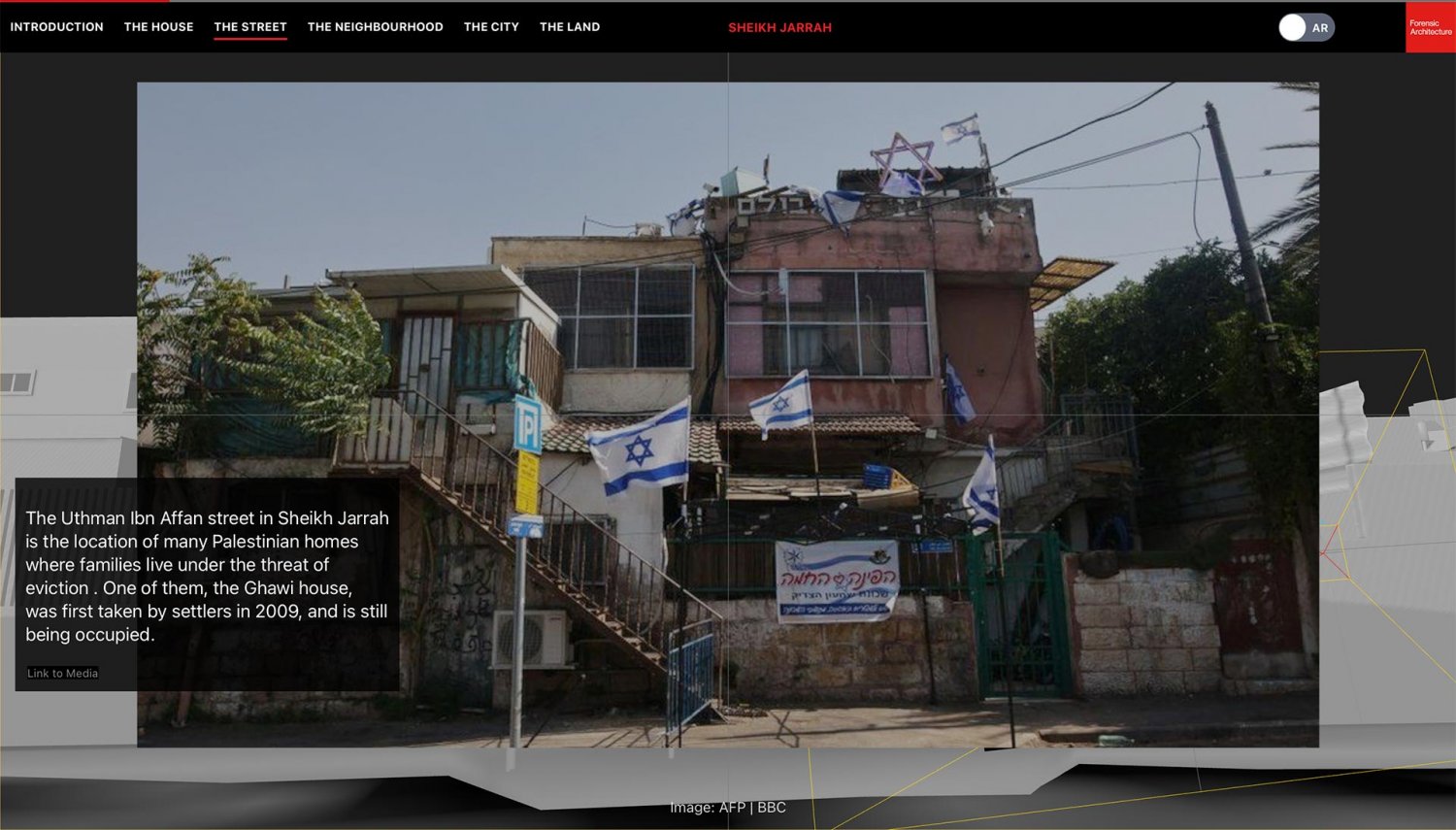
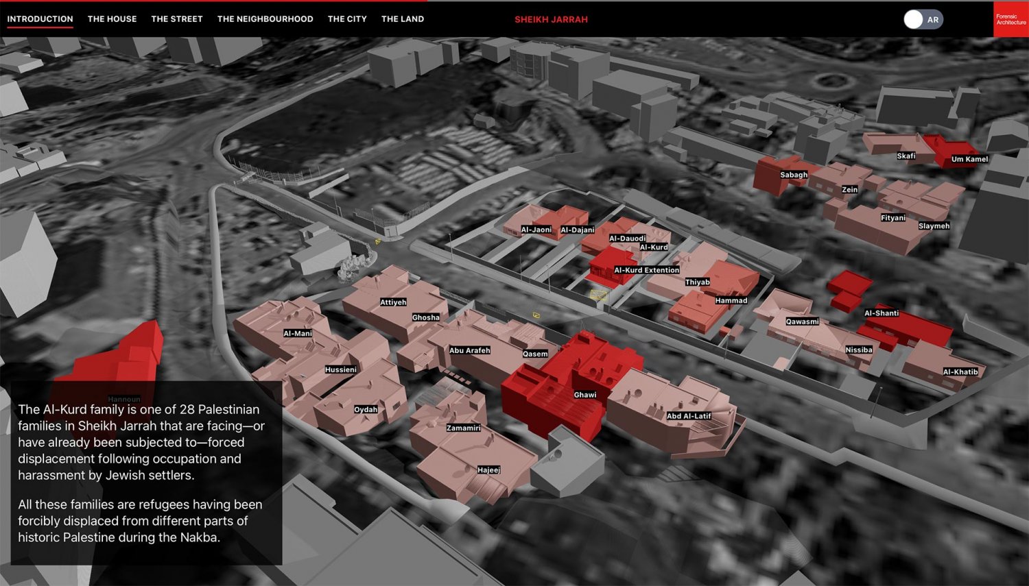
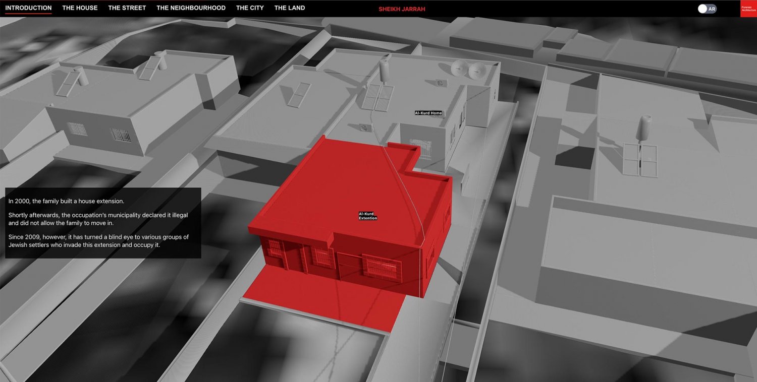
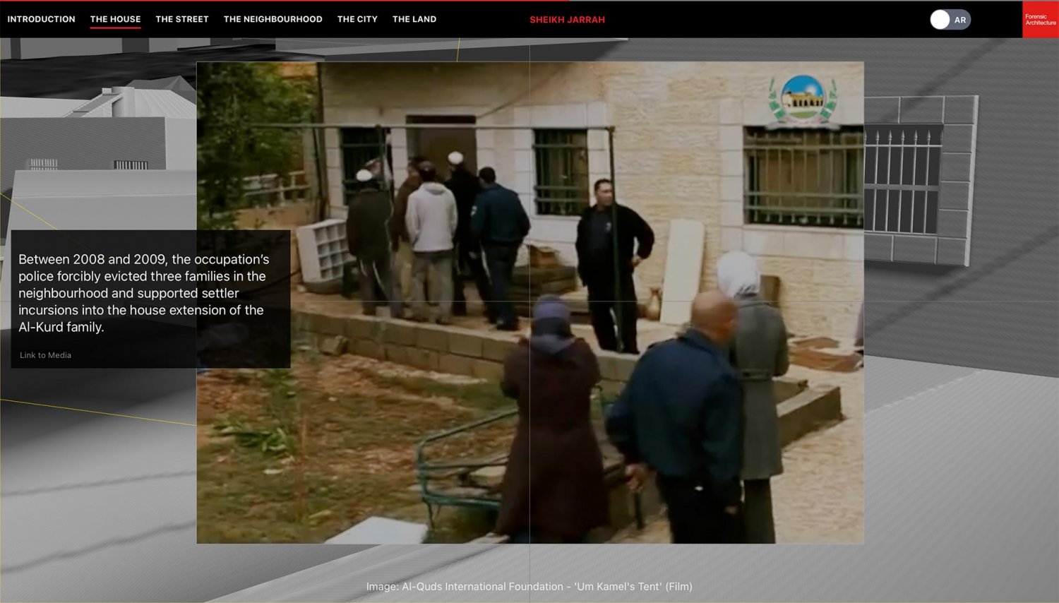
In May 2022, Forensic Architecture released an interactive digital platform to convey an urban narrative, “Sheikh Jarrah: Ethnic Cleansing in Jerusalem.” Working with activists and lawyers in the city, Forensic Architecture designed and built the platform to explain “the policies and practices through which Palestinian families in the East Jerusalem neighborhood of Sheikh Jarrah are being forcibly displaced of their properties, and their protracted struggle with the Israeli courts and various settler groups.”1 As their website further explains: “The story traverses multiple scales starting from homes invaded by settlers, and moves to the street, neighbourhood, city and the land, showing how colonial practices and apartheid planning displace Palestinians.”2

We recently spoke to Nour Abuzaid, 33, an architect, computational designer, and web developer, who was the lead researcher on the project, to learn more about it.

Abuzaid, a Palestinian originally from Gaza who holds a master’s degree in architectural design from Istanbul Technical University, conducted spatial research and created an interactive urban narrative platform. She worked with her colleague Jumanah Bawazir, an assistant researcher who is also a multidisciplinary designer and poet.

Nour Abuzaid headshot

Nour Abuzaid

Credit: 

Courtesy of Nour Abuzaid and Forensic Architecture

Headshot of Jumanah Bawazir

Jumanah Bawazir

Credit: 

Courtesy of Jumanah Bawazir

Forensic Architecture

Forensic Architecture, a multidisciplinary research agency formed in 2010 by Eyal Weizman at Goldsmiths, University of London, develops techniques and technologies through advanced architectural and media research to investigate situations of state violence, armed conflict, environmental destruction, and human rights violations around the world.

Initially, Forensic Architecture launched with the aim of investigating human rights violations and state crimes by finding means of evidence production. In operating across the field, the laboratory, and the forum (such as media and the legal process), the agency has had a pivotal role in documenting human rights violations and pushing for the implementation of international law in various parts of the world.

Their work proved fundamental in garnering the support of international human rights organizations. In some instances, the agency even got states to admit to crimes, such as the case of Israel’s use of drones and airburst white phosphorus munitions in urban environments during Israel’s war on Gaza (December 2008–January 2009). On the their Gaza projects entailed conducting an archaeological excavation (from the seventh century BCE) and onto 2022, through which they revealed human rights violations in urban areas. This proved worthy particularly in the oral statement delivered by the Ramallah-based human rights organization Al-Haq, on behalf of partner organizations, during the Human Rights Council 49th Session, and was followed with a report depicting, with archaeological evidence, Israeli erasure of Palestinian heritage in Gaza.3

Al-Haq

Al-Haq, one of the first human rights organizations in the Arab world, promotes the rule of law in the occupied Palestinian territories

The Architecture of Occupation—Hollow Land

The cover of Hollow Land, by Eyal Weizman

The cover of Hollow Land, by Eyal Weizman

Credit: 

Simon Brown

Headshot of Eyal Weisman

Eyal Weisman

Credit: 

David Ausserhofer / Robert Bosch Academy

The groundwork for Forensic Architecture was laid in the founder’s 2007 book, Hollow Land: Israel’s Architecture of Occupation. In it, Weizman carefully studied the architectural mess that Israel has created in the occupied Palestinian territories. A professor of spatial and visual cultures (at Goldsmiths), he explored the careful and methodical way in which Israel has used architecture as a tool for spatial control in the occupied territories. According to Weizman, much of what we see in the chaos and confusion surrounding the occupied territories had in fact been baked into Israel’s masterplan of 1968 that aimed to zone out Palestinian areas and dissolve territories into new establishments. As Weizman describes in the chapter titled “The Politics of Verticality,” “Palestinians had been forced into a territorial patchwork of sealed islands around their cities, towns, and villages, within a larger space controlled by Israel.”4

Weizman further explains how Israel’s architectural transformations have been demographically motivated. By and large, Israel’s spatial technologies and practices (in the use of the territorial, geographical, urban, and architectural space) were used toward a system of colonial control, he demonstrates.

Sheikh Jarrah: A Microcosm of Palestine

The Ghawi house on Uthman Ibn Affan street in Sheikh Jarrah was first taken by settlers in 2009

The Uthman Ibn Affan street in Sheikh Jarrah is the location of many Palestinian homes where families live under the threat of eviction . One of them, the Ghawi house, was first taken by settlers in 2009, and is still being occupied.

Credit: 

Forensic Architecture, “Sheikh Jarrah: Ethnic Cleansing in Jerusalem” 

Abuzaid explains that Forensic Architecture has become a research agency aimed to investigate violations of human rights by focusing on architecture and how spatial control has been used as a tool for domination. She and Bawazir investigated the Sheikh Jarrah neighborhood in the year 2021, when 4 of the 25 involved Palestinian families (themselves refugees from 1948, who had all been served with eviction notices decades before) were at risk of imminent expulsion by Israel. (The total number of affected families is 28, but 3 had already been forcibly expelled from their homes.) Unlike other Palestinian Jerusalemite families threatened with expulsion, the Sheikh Jarrah families spoke publicly about their situation and mobilized global solidarity. The hashtag #SaveSheikhJarrah trended worldwide, calling attention to the injustice against the Palestinian inhabitants of Jerusalem.

The research team came to share the families’ assessment that Sheikh Jarrah is a microcosm of Palestine. In many ways, this neighborhood in East Jerusalem offers a replay of the Nakba and the ethnic cleaning of the land in real time. It provides an in vivo demonstration of Israeli practices of displacement imposed on Palestinian Jerusalemites, including but not limited to zoning policies, the Separation Wall, Jewish-only settlements (designed to control the indigenous population and deny them territorial continuity), and building permit policies (which massively discriminate against Palestinians), Abuzaid explained. As she put it, “Sheikh Jarrah represents larger Palestine—namely Jerusalem, the West Bank, the Gaza Strip, and the 1948 areas.”

The research team quickly realized that Sheikh Jarrah is a microcosm of Palestine.

How to Map the Space When You Are Denied Access to It?

Once the team embarked on the project, the first question they tackled was, “How do we begin to locate the homes of the threatened families in Sheikh Jarrah?”

She was at a disadvantage: She had been born in Gaza and lived in Sudan, Syria, Istanbul, and most lately in London, and she has no direct experience of Jerusalem’s neighborhoods. Her parents, originally from Ramleh and Lod, had become refugees in Gaza, where she lived in her formative years. “I may have been to Jerusalem when I was three years old. The political situation is different now; I can’t visit any more,” she remarks. And like many Palestinians in exile (and currently in Europe), Jumanah too had no access to Jerusalem, although her grandmother had actually lived in Sheikh Jarrah for a while after being displaced during the Nakba.

The idea of building the houses through digital technology was thus an intimate process for the two women, who had to create images in the virtual space. As they are denied access to the space itself, “it was hard to define the framework scope.” It was also difficult to restrict themselves to one neighborhood (Sheikh Jarrah); other households in Silwan, Beit Hanina, and other Jerusalem neighborhoods were facing similar threats. However, the team decided to focus on Sheikh Jarrah and draw the connection between the neighborhood and the rest of the city. They successfully developed the project, which they titled: “Sheikh Jarrah: Ethnic Cleansing in Jerusalem.”

The architects built a 3D-interactive platform that “reveals how Israeli colonial practices and apartheid policies mobilize infrastructure and the lived environment to displace Palestinians at the level of the street, the neighborhood, the city, and on the land more broadly.”5 The platform allows users to zoom in on specific areas, from micro to macro—the house, the street, the neighborhood, and the land.

Digital map of homes in Sheikh Jarrah that have been served with eviction notices

A digital map of the homes of the families in the neighborhood who have been served with eviction notices

Credit: 

Forensic Architecture, “Sheikh Jarrah: Ethnic Cleansing in Jerusalem” 

El-Kurd house and extension in Sheikh Jarrah

The home of the El-Kurd family and the extension they built which was taken over by Jewish settlers in 2009

Credit: 

Forensic Architecture, “Sheikh Jarrah: Ethnic Cleansing in Jerusalem” 

Among the 28 affected houses are two that have been in the news, those belonging to the Al-Kurd and the Ghawi families. The Al-Kurd family built an extension to their home when they outgrew the original home, and Israeli settlers moved into the extension; the Al-Kurds have been forced to contend, day and night, with threatening, state-protected Israelis who want to drive them out and claim the remainder of the house. The Ghawi family was forcibly removed from their home in 2009. The Sheikh Jarrah families have been in protracted legal battles with settler groups and Israeli courts.6

The interactive platform allows users to scroll down from the street and neighborhood of Sheikh Jarrah and to place it within the larger view of Jerusalem and a broader perspective of the land. It also provides some contextual information on the intersecting means of ethnic cleansing that are used against Palestinians in the city.

The platform allows users to zoom in on specific areas, from micro to macro—the house, the street, the neighborhood, and the land.

Mapping Technologies Are Not Neutral

The two architects began the project using information in the public domain to map all homes undergoing displacement orders and threats. They knew that infographics, charts, and graphs were needed to help tell the story. Open-source intelligence allowed them to analyze data, and software allowed them to identify and estimate geographic positions of objects.

The goal was to provide a 3D model that would give context to the images of Sheikh Jarrah: to make them both spatially and visually explicit. Basically, the idea they had was for mapping—which refers to making a map, or a matching process by which to match or identify a set.

Abuzaid explained that it was extremely difficult to work on this project. “Mapping has colonial history,” she added. For one thing, data collection is arduous, she noted. The policies of intimidation make most Palestinians in Jerusalem prefer to remain silent. Oftentimes, orders from the authorities for home demolitions, after being served on the family, are simply left hanging; five or six years can pass without follow-up, so the residents stay silent to avoid calling (unwanted state) attention to themselves.

But the 28 families of Sheikh Jarrah chose to speak up and go public; they wanted and even demanded attention. By so doing, they put their plight clearly on display for the international community.

Sheikh Jarrah families slated for expulsion address the media in Sheikh Jarrah, November 2, 2021

Members of some of the Sheikh Jarrah families slated for forcible expulsion address the media during a press conference in Sheikh Jarrah, November 2, 2021.

Credit: 

Ammar Awwad, Alamy Stock Photo

Even after the families went public, however, access to the physical premises and their surroundings was challenging. “Access to images and data—street maps, Google searches, websites, 3D technologies, and so on—in the public domain is actually lower in Palestine than it is elsewhere in the world,” Abuzaid noted.

One of the methods used for mapping in this project was photo matching (a method developed by Forensic Architecture where photos are overlaid on 3D models). Matching involves positioning the camera from the standpoint of the person who is physically standing in a specific space—and then calibrating the focus position. The architects had to add details from images themselves—and often they had to fix the 3D model to match.

“Like a puzzle . . . We had to piece the parts together,” Abuzaid explained. In addition to photo matching, they also used the method of geolocation—which refers to spatial features of images. This enabled them to establish the exact spot where certain photos or videos were captured, and thus allowed them to study its content. They did this to document stun grenades and beatings.

“Like a puzzle . . . We had to piece the parts together.”

Nour Abuzaid, Forensic Architecture

Screenshot from the Forensic Architecture interactive platform

Screenshot from the Forensic Architecture interactive platform that illustrates the photo matching method

Credit: 

Forensic Architecture, “Sheikh Jarrah: Ethnic Cleansing in Jerusalem” 

Screenshot from the Forensic Architecture interactive platform

Screenshot from the Forensic Architecture interactive platform that illustrates the photo matching method

Credit: 

Forensic Architecture, “Sheikh Jarrah: Ethnic Cleansing in Jerusalem” 

The process was painstaking. “It took hours to find the locations of some images,” Abuzaid commented, as “mapping technologies are not neutral; they have a long history of being used as colonial tools.” She explained that Israelis can easily access maps through the municipality that Palestinians (even the Palestinian Authority and human rights organizations) cannot access. The lack of access to information provided the team with a lesson in power dynamics.

Abuzaid’s experience, as a Palestinian who has no access to Jerusalem, is typical of the experience of most Palestinians under occupation, for whom Jerusalem might as well be on another planet. “Palestinians are displaced in different forms and on several scales,” she noted.

The Silver Lining: Grassroots Activism

Ultimately, “the story of Palestine is not very complicated to understand,” Abuzaid said. She summarized that although the research process was complex, the reality it reconstructed is rather clear. “There are various tools and mechanisms that the Israeli government uses to make the reality of Palestinian displacement seem ambiguous or complicated, but it is actually not complicated at all: It is intentional and systematic. These are not individual arbitrary incidents,” Abuzaid said.

By not granting permits, zoning green areas, and using other methods, Israel asserts its control and its will. Even zoning green areas to use for parks offers another avenue to confiscate Palestinian land. “Trees are used to hide traces of demolished houses,” Abuzaid said. Always, she added, Palestinians find that Israeli laws are manipulated to favor Jewish settler groups.

Although the research process was complex, the reality it reconstructed is rather clear.

Abuzaid recalls feeling somewhat helpless when hearing about the eviction notices served to Sheikh Jarrah residents before the team started researching displacement there. In due time, the team came to find it remarkable that the Palestinians keep building despite the ongoing challenges. On the other hand, they also marveled that the municipality has not been able to meet its long-held target goal (as noted in the 1973 documents relating to Jerusalem’s rate of development) maintaining a demographic ratio in Jerusalem of 73.5 percent to 26.5 percent in favor of Jews;7 despite all the coercive state measures inflicted on Palestinian Jerusalemites, they remain at least 40 percent of the population (see Palestinians in the Jerusalem Municipality). The resistance of Palestinians to the array of adverse state measures, she expressed, has attracted domestic and international respect and solidarity.

“We wanted to learn more about the city,” Abuzaid summarizes the basic idea of the project. “It was a way to work with the community and get in touch with the people,” she shared. Creating the interactive platform was thus another tool, used through the Internet, that helped raise public solidarity with residents, while the Israeli court system had to delay its decision-making in several instances.

Essentially, the platform provided clearly visible and easily understandable images to assist those outside of Jerusalem (and even those away from the neighborhood) to see what has happened in the neighborhood of Sheikh Jarrah.

Creating the interactive platform was thus another tool, used through the Internet, that helped raise public solidarity with residents.

Notes

1

Forensic Architecture, “Sheikh Jarrah: Ethnic Cleansing in Jerusalem,” June 20, 2022.

2

Forensic Architecture, “Sheikh Jarrah.”

4

Eyal Weizman, Hollow Land: Israel's Architecture of Occupation (London: Verso, 2007), 12.

5

Forensic Architecture, “Sheikh Jarrah.”

7

Inter-ministerial Committee to Examine the Rate of Development for Jerusalem, Recommendation for a Coordinated and Consolidated Rate of Development [in Hebrew], Jerusalem, August 1973, 3.

Load More Load Less