Credit: 

Jerusalem Story Team

Backgrounder

Where Is Jerusalem? The Uncertain and Unfixed Boundaries of the City

View more on
What Is Jerusalem?
View more topics under
Foundations

Snapshot

The reality of Jerusalem today is that multiple and competing boundaries and constructs have been unilaterally imposed or proposed, all in the context of a city that in fact remains undefined in any official sense that would be considered legitimate by all its residents. And “Jerusalems” of the near and distant past still firmly exist in the collective consciousness of all communities living in the city as well.

Those on the ground are left to navigate a labyrinthine maze of borders, jurisdictions, and fragmented spaces that are difficult for non-natives to fathom.

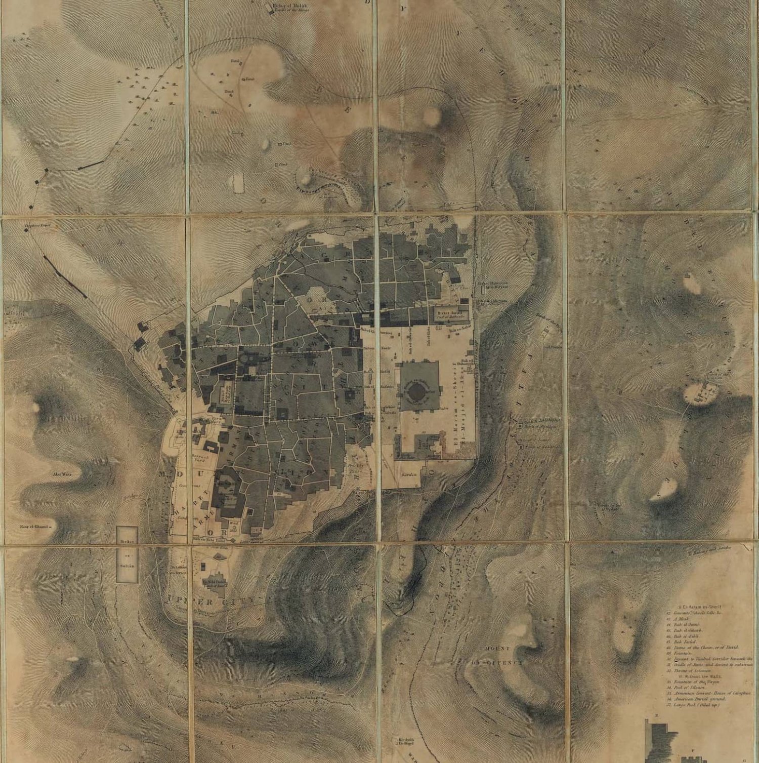
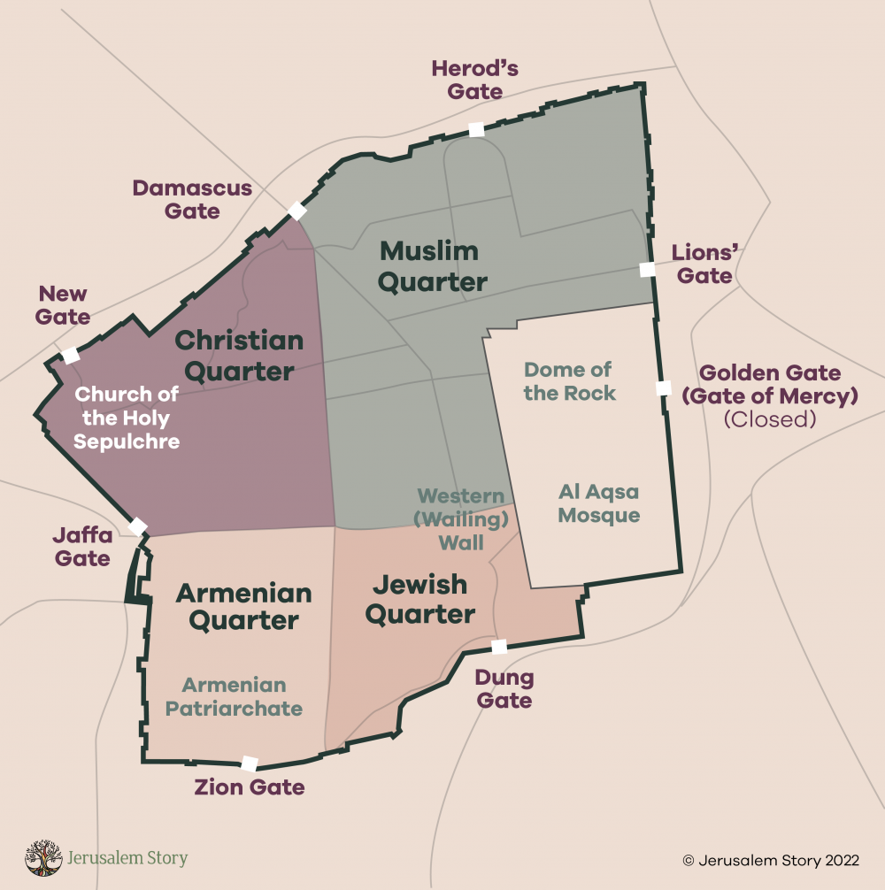
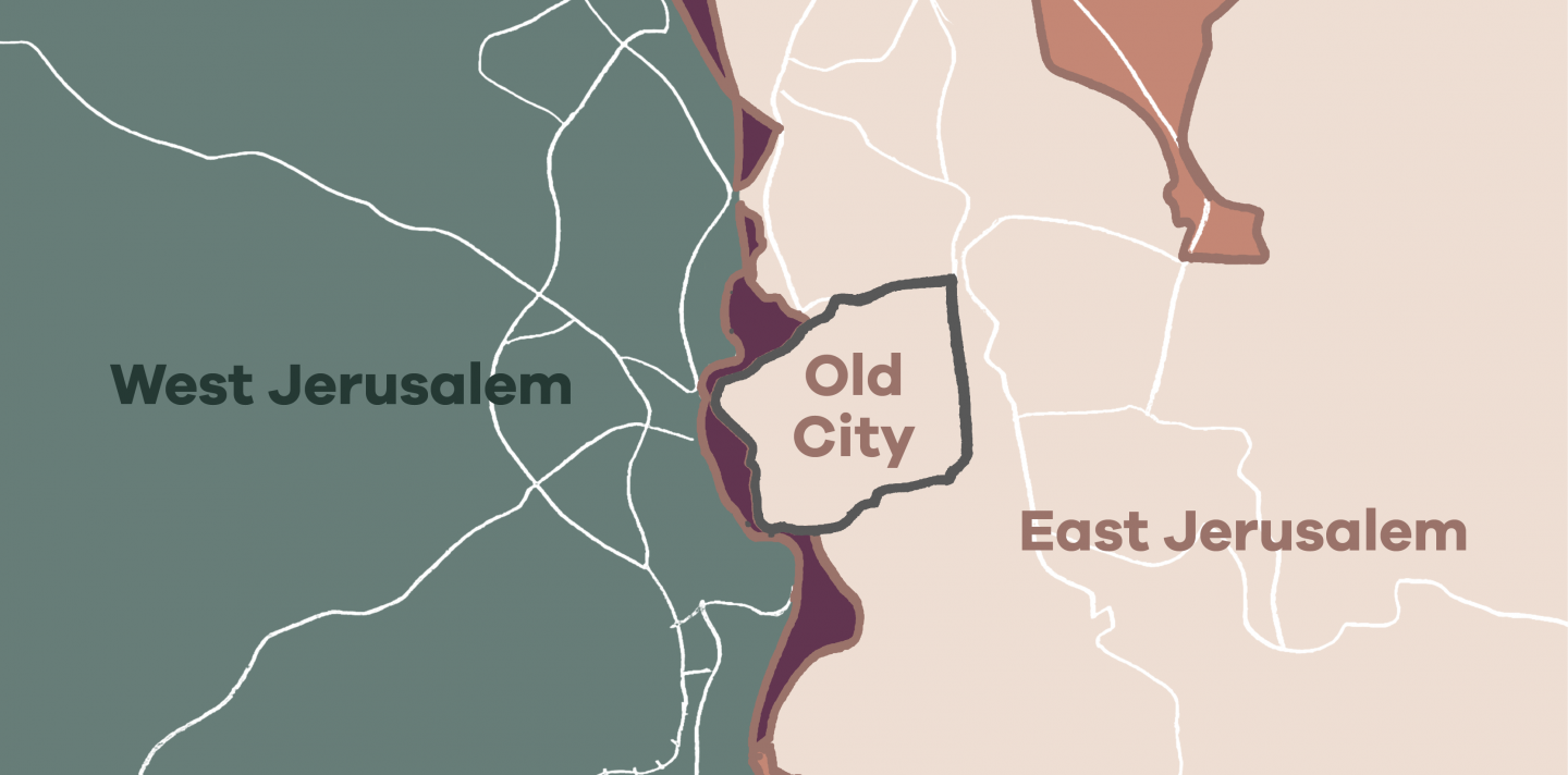
Jerusalem—al-Quds in Arabic—has existed for over 5,000 years within the mountainous region between the Mediterranean Sea and the Jordan River. The word “Jerusalem” acquired multiple territorial meanings across the ages, a plurality of geographical designations contingent on local understandings of belonging to the city and its region. These meanings extend from the historical core of the Old City to as far north as Ramallah, as far south as Bethlehem, and as far east as Jericho.

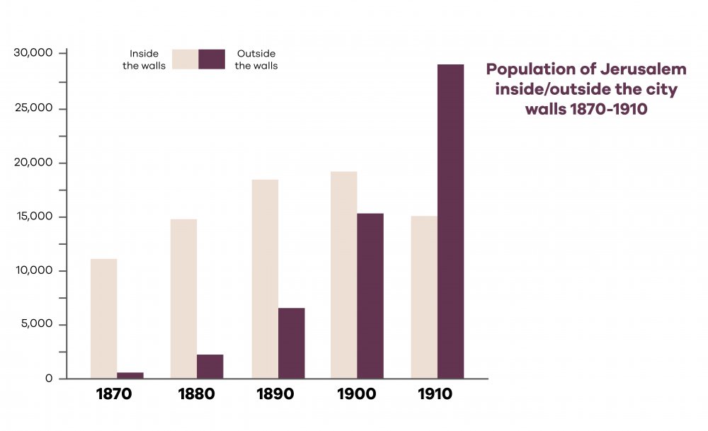
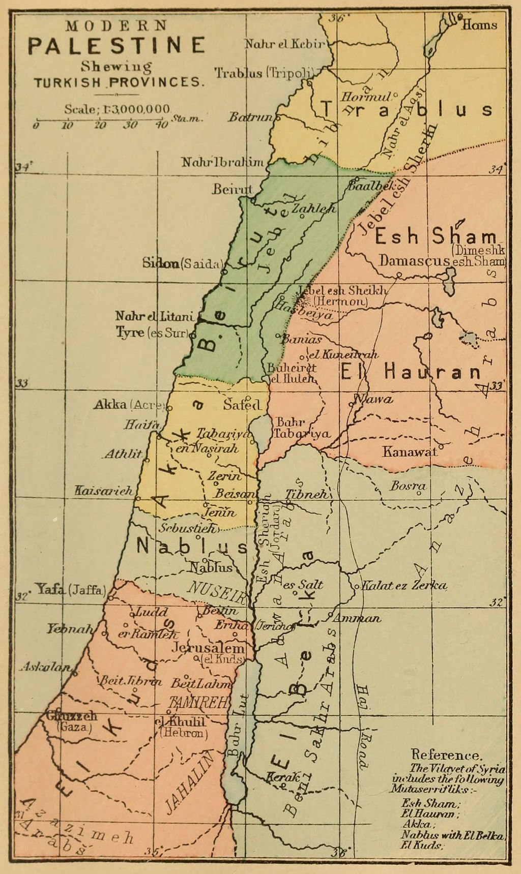
Over the course of its history, and especially since the late Ottoman period, the city of Jerusalem witnessed major expansions to its boundaries. Since the colonization of Palestine by the British in 1917, and later on with the establishment of the State of Israel, the city’s boundaries have shifted and expanded according to various political realities. In the past century, these shifts have mostly been imposed upon the indigenous community without its consent, to the point that today, there is no single agreed-upon definition of the city. Rather, there are multiple and competing boundaries and constructs unilaterally imposed or proposed, making even the very mention of “Jerusalem” a potential source of miscommunication and contention: Which Jerusalem do you mean?

The shifting and forced redefining of borders has had devastating consequences for the Palestinians of Jerusalem, who are forced to navigate among these overlapping multiple “Jerusalems” every waking moment.

For those who wish to know and understand this community and its story within the city, as well as the story of Jerusalem itself through this lens, the starting point is an overview of the complexities involved in even defining where Jerusalem is.

Here we invite you to explore the question, “Where is Jerusalem?”

Map 1: The Old City of Jerusalem

“Plan of the Town and Environs of Jerusalem” by James Wyld, Geographer to the Queen, 1841

“Plan of the Town and Environs of Jerusalem” by James Wyld, Geographer to the Queen. “From the original drawing made from the survey in the month of March 1841.” Cropped and modified from the original.

The Old City (al-Balda al-Qadima in Arabic) refers to the residential area within the defensive city walls, which were last (re)built by the Ottoman sultan Suleiman “the Magnificent” between 1537 and 1541. Interpenetrated within the walls are 34 towers and 7 gates, including the main entrances to the city: Damascus Gate/Bab al-Amud and Jaffa Gate/Bab al-Khalil (see The Gates of the Old City). The seven open gates join the interior of the Old City with the various neighborhoods outside the walls that surround it and that are historically attached to it, such as Musrara and Wadi al-Joz.

The area of the Old City, which spans only about 900 dunums (225 acres or 0.91 sq km),1 comprised the entirety of the city of Jerusalem from antiquity until the second half of the 19th century. Since its establishment, the Old City has been demolished 18 times by both natural and human forces.2 Thus, it is also underlaid by many layers of older formations of the city.3

The age-old construct of “Jerusalem as the Old City” endured and remains salient today. In fact, some people who say “Jerusalem,” especially Jerusalemites themselves, may mean just the Old City, and might use both terms interchangeably.

The inner quarters

During the second half of the 19th century, the Old City began to be conceptually and cartographically divided into distinct quarters: Muslim, Christian, Armenian, Jewish.4 While conveniently applied today, this “simplistic schema”5 was mostly a European invention. In fact, communal life was never rigidly defined or separated on ethnoreligious lines as the “four quarters” construct suggests. These designations were not consistent, and they changed multiple times throughout Jerusalem’s long history.

In addition, if we were to view Jerusalem as separated into groups, each one of those four communities had and has numerous subgroups (e.g., Sunni, Shiite, Ismaili, Druze within Islam; Russian and Greek Orthodox, Roman and Greek Catholic; Armenian Catholic; various types of Protestants, Anglicans, Ethiopians, Copts, Maronites, Melkites within Christianity; Eastern (Sephardi and Oriental) and Western (Ashkenazi) Jews; native-born and immigrant Jews).

Moreover, all these groups had many crosscutting interrelationships shaped by myriad other factors such as duration in the city (immigrant vs. native); geographic origin; religiosity (secular vs. religious); language spoken (an attribute that cut across communities); Ottoman citizenship (which determined rights to own real estate and to vote); place of residence (inside the walls vs. those who began building and moving outside in the late 19th century); and more.6 Thus, historically, diversity rather than homogeneity has always been the defining character of the city of Jerusalem.7

A map of Jerusalem's Old City and its gates

Credit: 

Jerusalem Story Team

Historically, diversity rather than homogeneity has always been the defining character of the city of Jerusalem.

Map 2: The “New City”

Credit: 

Jerusalem Story Team

In the second half of the 19th century, the crowded conditions inside the Old City walls led to the earliest movement outside them. The residential areas outside the Old City walls to the west, northwest, and northeast began to be gradually populated as wealthy Jerusalemite families began building summer homes in the area, along with farming families who set up small farms, later followed by the middle class.8

Small Jewish residential areas were among the first to be developed outside the Old City, as early as the 1850s, even before Jewish immigration and settlement of the city began to intensify, forming what is referred to in Zionist discourse as the “Old Yishuv.”9

Christian churches and institutions, particularly, the Russian and Greek Orthodox and Armenian, also built up residential spaces outside the walls, which contributed “to a large Christian presence in parts of the city.”10

Increased Ottoman presence in the area, which provided residents with a sense of security outside the walls, as well as the economic growth of the city, gave “a variety of pull factors to encourage the Jerusalem population to begin building outside the walled city.”11

Building started intensifying such that the city “literally reached outside itself to become a ‘new city’—one that expanded west, toward the sea,” abutting the Jerusalem-Jaffa corridor.12 The new city grew so rapidly and attracted so many of the Old City dwellers from various economic and religious backgrounds that by the end of the 19th century, it housed half of Jerusalem’s residents.13

The city “literally reached outside itself to become a ‘new city’ . . .

The Shifting Population Balance Inside and Outside the Old City Walls, 1870–1910

Graph chart of the shifting population of Jerusalem's Old City, 1870-1910

From 1870 to 1910, the ratio of the population inside the Old City walls versus outside shifted dramatically, as shown in this bar graph. 

Credit: 

Adapted from Dan Bahat, The Illustrated Atlas of Jerusalem (New York: Simon & Schuster, 1990), 126.

In 1895, the term “New City” was introduced in a map rendered by a German Protestant missionary, Conrad Schick.14 Thus, out of the late Ottoman period emerged the New City of Jerusalem, born between 1880 and 1900, which included the German Colony, the Greek Colony, Qatamon, Talbiyya, and al-Baq‘a, Mamilla, and Maliha neighborhoods.

In addition, the city saw a major expansion northwest toward the neighborhoods of Wadi al-Joz, Sheikh Jarrah, and al-Tur.15 The communities living in the nearby villages adjoining the walls of the Old City, such as al-Nabi Dawud, al-Tur, Silwan, al-‘Izariyya, and Abu Tur, enjoyed the same level of protection provided to the walled city, making these communities feel that they were part of the city.16

During this period, highways and roads were paved, connecting Jerusalem to other Palestinian cities and encouraging economic growth. As well, to accommodate the new neighborhoods, in 1889, the New Gate was opened in the walls, the first such opening since the walls were built in the 16th century.

Map 3: Ottoman Jerusalem

A map of Palestine showing the Ottoman provinces with Jerusalem marked El Kuds

Modern Palestine showing the Ottoman provinces. The Jerusalem mutassariflik is labeled El Kuds.

Source: 

From Palestine, by Claude Reignier Conder (G. Phillip & Son, London, 1889)

Accompanying the expansion of the city outside the walls came a wave of administrative and territorial reorganization across the Arab provinces in the late 1850s and 1860s, whereby the Ottoman Empire first established Jerusalem with its Old and New sectors as a municipality (baladiyya) in the 1860s.17 Reflecting its importance, Jerusalem was the first Ottoman town after Istanbul to be granted this new status.18

This municipality functioned from the 1860s to the end of the Ottoman Empire (1917) and beyond, to the 1930s, and it created the capacity for Jerusalem to embody “the entire urban community without regard to religious and ethnic differences.”19 Despite it being declared as a municipality, there were no clear boundaries for the Ottoman city Jerusalem at the time. Rather, the municipal administration gave services to the areas surrounding Jerusalem’s Old City that came under its jurisdiction.20

In 1872, as part of the same wave, the Ottomans established a very large autonomous administrative province of Jerusalem called the Mutassarifate of Noble Jerusalem (al-Quds al-Sharif). The Mutassarifate of Jerusalem comprised five large districts: Jerusalem, Jaffa, Gaza, al-Khalil (Hebron), and Beersheba. The city of Jerusalem lay at its heart and became its provincial capital.21

Jerusalem was the largest district of late Ottoman Palestine. The other two, Nablus and Acre, were defined as sanjaks, a local administrative unit that was lesser in importance and smaller in size. Uniquely, Jerusalem’s governor reported directly to Istanbul, “which shows the special attention the government paid to this territory.”22 In 1906, the districts of Nazareth and Tiberias in the Galilee were added to the Mutassarifate of Noble Jerusalem, largely in order to facilitate an increased influx of pilgrims who wanted to visit the holy Christian sites in both Jerusalem and the Galilee.23

Map 4: British Mandate Jerusalem (1917–48)

Credit: 

Jerusalem Story Team

On December 9, 1917, the mayor of Jerusalem surrendered the city to the British military troops that entered the city on the heels of fleeing Ottoman soldiers, ushering in a period of British military rule. In April 1920, the Allied Powers conferred the mandate for Palestine to Britain. The British military rule then converted to civilian rule. The mandate authorities granted Jerusalem the status of a municipality in 1921.24

While the Arab notables and ashraf lived in the Sheikh Jarrah and Wadi al-Joz neighborhoods just outside the Old City, in the late 1920s, the new Arab middle classes began to move to the farther-flung western suburbs of Qatamon, Talbiyya, and al-Baq‘a.25 Building picked up such that by the early 1940s, most of these outlying suburbs further extended to the boundaries of the nearby Palestinian villages, including Lifta, Deir Yasin, and ‘Ayn Karim.

The colonial mandatory government reset the boundaries of Jerusalem in 1931,26 thereby recognizing the expansion outside the walls as the new boundaries of the city. These new shifts were controversial in that the pattern that the new borders followed swung to the west to encompass new estates established by Jewish settlers, while they excluded Arab villages actually abutting the Old City walls to the east, such as Silwan.27 These boundaries remained in place until the 1948 War.

By 1947, as the mandate neared its end, Jerusalem had become an expanded, vibrant, and cosmopolitan city. The New and Old areas grew in mutual dependency and enjoyed economic growth. Jerusalem had become a social and economic center connecting a vast network of surrounding villages and towns offering educational and business opportunities to a growing number of people from beyond the city.28

Map 5: Corpus Separatum Jerusalem

Credit: 

Jerusalem Story Team

In November 1947, after Britain announced its intention to end the mandate and withdraw from Palestine, the United Nations General Assembly (UNGA) passed UN Resolution 181(II), or the UN Partition Plan. Upon the recommendation of its Special Committee, this plan recommended the partition of Palestine into two states, one Arab and the other Jewish, with Jerusalem as a separate international, standalone entity.29 The resolution designated Jerusalem as a corpus separatum to be administrated by a UN trusteeship for 10 years, followed by a referendum.30 The plan envisioned an enlarged area that was more like a city-region, with boundaries that went far beyond the Jerusalem municipal boundaries and included numerous neighboring Arab villages and towns, including Bethlehem and Beit Jala.

The Partition Plan was never implemented. However, legally, the plan could not be cancelled without the parties’ consent.31

Map 6: Jerusalem Divided by the Green Line (1949)

Credit: 

Jerusalem Story Team

With the outbreak of the 1948 War, most of the Palestinian population, including those who lived in the area of the New City, were displaced out of their homes and hometowns and made refugees.32

In Jerusalem, during the war, Israel seized 84 percent of the municipal surface area as it had been designated by the British Mandate, including an isolated enclave in the eastern side on Mount Scopus, where the Hebrew University and the Hadassah Hospital had been built before 1948. Jordan, which had occupied the eastern side, was left with 11.5 percent of the area of the city.33

The remaining 4.39 percent became “no-man’s-land,” referring to strips of land that were not subject to the control of either Israel or Jordan. Rather, from 1948 to 1967, they came under UN supervision.34

By the war’s end, Israel had occupied considerably more than its UN-allocated portion of the country and gained control over 77 percent of historic Palestine.35

In 1949, the armistice agreement between Israel and the Arab states surrounding historic Palestine was signed. These lines were drawn by negotiators in green ink on a map and were therefore referred to as the Green Line. This line represents both the armistice or ceasefire boundaries at the end of the 1948 War and the unofficial demarcation of the State of Israel’s boundaries at the time. This arrangement and this line divided Jerusalem, creating the unofficial boundaries of a Jewish West Jerusalem under Israeli sovereignty and a Palestinian East Jerusalem under Jordanian sovereignty (after Jordan annexed it).

From that point on, these two sides of the city were referred to as “West Jerusalem and “East Jerusalem.” Between the lines, the implicitly understood meaning of these terms was also Jewish Jerusalem and Arab Jerusalem.

Between 1949 and 1967, Jerusalem remained divided, with the Jordanian part separated from the now-Israeli part by demilitarized zones, fences, and barriers.

Map 7: Israeli-Ruled West Jerusalem (1949–67) or “West Jerusalem”

Credit: 

Jerusalem Story Team

Before, during, and after the 1948 War, the Palestinian neighborhoods in the “New City” were emptied of their original inhabitants, who were banned from ever returning36 (see The West Side Story). The state seized and expropriated the properties and lands of the former inhabitants37 and gradually expanded Jewish settlement in the area.  

“West Jerusalem” is a purely postwar term,38 derived from the boundary set by the 1949 armistice agreement and the division of the city.39

On December 11, 1949, Israel unilaterally declared that West Jerusalem was the state’s capital.40 Previously a mixed Arab-Jewish area, what became “West Jerusalem” was now wholly Jewish, and it remains so to this day. Israel soon began to expand the boundaries of West Jerusalem further westward, in 1952, and then again in 1963.41

During the [1948] war, Israel seized 84 percent of the municipal surface area [of Jerusalem] as it had been designated by the British Mandate.

Map 8: Jordanian (Arab East) Jerusalem (1949–67)

Credit: 

Jerusalem Story Team

After the annexation of the West Bank by Jordan in 1950, the Jordanian government in 1952 recognized the municipality of East Jerusalem and expanded its boundaries from 2.2 sq km to 6 sq km,42 to include some areas south of the Old City, such as the village of Silwan.

Even before the official annexation of East Jerusalem (as part of the annexation of the entire West Bank by Jordan on April 24, 1950), the city played an important role in the Transjordanian area and functioned as a cultural, spiritual, economic, and political center. Therefore, by the time it was incorporated into Jordan, Jerusalem already had a strong network of connections to the broader Jordanian country and served as a sort of second capital.

In addition, Jerusalem became a hub for political opposition in Jordan.43 In 1955, Jordan recognized Jerusalem as a muhafaza (governorate), which included the jurisdictions of Ramallah, Bethlehem, and Jericho.

In 1964, the government sponsored a plan to widen the municipal boundaries and create a Metropolitan region. This plan, called the “Kendall Plan,” was supposed to extend the boundaries of the city to incorporate villages and towns around it. The 1967 War meant this plan was never implemented, and its development potential remained unrealized.44

Map 9: Israeli Municipal “Unified” Jerusalem (1967–Present)

Credit: 

Jerusalem Story Team

In early June 1967, during a war lasting six days, Israel occupied the West Bank (including East Jerusalem—then part of Jordan), the Gaza Strip and the Sinai Peninsula (part of Egypt), and the Golan Heights (part of Syria).

A day or so later, Israel incorporated Jerusalem under its municipal jurisdiction and expanded the 6 sq km boundaries of (East) Jerusalem, as it had formerly been delineated by Jordan, to 71 sq km. In so doing, the state absorbed 28 Palestinian neighborhoods, refugee camps, and villages that had formerly lain outside the city boundaries,45 including Beit Hanina, Shu‘fat, and Kufr ‘Aqab. Some of these neighborhoods were also split by the boundary, including Beit Hanina and Kufr ‘Aqab.46 On the other hand, some adjacent Palestinian villages and towns that had historically been connected to Jerusalem, such as Abu Dis and al-‘Izariyya, were excluded from these newly expanded city boundaries.

Over the decades that followed, the state expanded the western and eastern boundaries of the city multiple times (see Table 1), enlarging it exponentially to reach its current size of 125 to 126 sq km.47

Today, there is no single agreed-upon definition of the city.

Table 1 : Changes in municipal boundaries in Jerusalem since 1917

Years

Sovereign

Side of the city

Territory under municipal control

Area of control/expansion

1931–47

British Mandate

Both (all)

19.2 sq km

The British Mandate expanded the municipal boundaries westward to include Jewish settlements and excluded the Arab localities near the Old City to the southeast (such as Silwan).[1]

1949–51

Israel

West

16.26 sq km

The Green Line divided Jerusalem into an Israeli-controlled Jerusalem and a Jordanian-controlled Jerusalem. Israel got the larger western part of Jerusalem with the Jewish Yishuv and the depopulated Palestinian villages and neighborhoods, including the Hebrew University and the Hadassah enclave in the eastern side.

1952–62

Israel

West

33.5 sq km

The boundaries of West Jerusalem were expanded by Israel in 1952 and 1963 in order to include developments for a rapidly growing Jewish population, which almost doubled between 1948 and 1967.48

1963–66

Israel

West

38.1 sq km

The boundaries of West Jerusalem were expanded by Israel in 1952 and 1963 in order to include developments for a rapidly growing Jewish population, which almost doubled between 1948 and 1967.49

1949–67

Jordan

East

2.2 sq km

The Green Line that divided Jerusalem left Jordan with the 2.2 sq km area on the eastern side of the city, which covered the Old City and its closest northern environs.

1952–67

Jordan

East

6 sq km

In 1952, the Arab municipality of East Jerusalem extended the city’s boundaries to the surrounding villages (including Silwan).

1949–67

UN

In between

0.74 sq km

A few small areas were designated “no-man’s-land”—in the areas between the western and southern parts of the Old City walls and the Musrara neighborhood.

1967–85

Israel

West and East

108 sq km

Against international law, after occupying East Jerusalem in 1967, the Israeli Jerusalem municipality unilaterally extended its boundaries to include not only the eastern part of the city but the 70 sq km region surrounding East Jerusalem to the north, east, and south, which included 28 Palestinian localities including Kufr ‘Aqab, the adjacent airport, Shu‘fat refugee camp, Umm Tuba, and vast amounts of open space intended for future residential and industrial development.50

1985–93

Israel

West and East

108.5 sq km

In 1985 and 1993, the municipal boundaries were twice redrawn and stretched westward, by 0.5 sq km the first time and 17.9 sq km the second time. The purpose of these shifts was to control the apparent demographic trend that threatened the relative Jewish majority in the city.51

1993–2000

Israel

West and East

126.4 sq km

Although multiple Israeli politicians and political bodies at the time preferred to further eastern annexation by extending the municipal boundaries eastward, the Interior Ministry decided to implement this expansion westward instead, to avoid provoking the Palestinians.52

Data about years 1923–49 are from PASSIA, “Municipal Boundaries of Jerusalem.” Data about 1925–2020 are from “The Municipal Area of Jerusalem, 1952–2020,” from the Jerusalem Institute for Policy Research: “Chapter 1 Area: 1952–2020,” in Statistical Yearbook of Jerusalem (2019). Data about 1925–2020 are from “The Municipal Area of Jerusalem, 1952–2020.” Data about the details of those changes also retrieved from Sharkansky and Auerbach, “Which Jerusalem?”

Map 10: Jerusalem Post-Oslo

Credit: 

Jerusalem Story Team

The Oslo Accords, which were signed between Israel and the Palestine Liberation Organization (PLO) from 1993 to 1995, designated Jerusalem as a permanent-status issue for later negotiation (which never took place). The Accords grant Israel complete and sole control of the city that falls under Israeli sovereignty and bar the Palestinian Authority (PA) from having any jurisdiction there.

The Accords did not define or specify a boundary for Jerusalem. Nor did they detail the boundaries of a territory that the PA (established by the Accords) would eventually govern. Nor did they address the future status of Jerusalem.

The Oslo Accords did, however, divide the rest of the West Bank (excluding East Jerusalem) into three areas of governance: A, B, and C:

  • A: Areas administered by the PA (around 3 percent of the West Bank)
  • B: Areas that fall under joint administration, with the PA handling civil affairs and Israel handling security affairs (around 23 percent)
  • C: Areas solely administered by Israel (around 72 percent)53

The Oslo-imposed division of the larger Jerusalem region into Areas A, B, and C fragmented the region that had historically been a coherent unit into different legal-political zones. The absolute majority of the Jerusalem region that is not under Israeli municipal control is Area C (89 percent), which means that it is under complete Israeli rule. Only some of the areas like Abu Dis and al-‘Izariyya are considered Area B (10.6 percent), and only a very small amount of that area is A (less than 1 percent).54

The Oslo Accords grant Israel complete and sole control of the city that falls under Israeli sovereignty and bar the Palestinian Authority (PA) from having any jurisdiction there.

Map 11: Palestinian Governorate (Muhafazat al-Quds)

Credit: 

Jerusalem Story Team

Palestinians have long viewed Jerusalem, and other Palestinian cities, as an urban center for a larger region of villages and towns in which individuals have a sense of belonging to the city and environs. Therefore, when the PA was established in 1995, and it had to divide the area it administered, it opted to divide it into governorates, or districts (muhafazaha in Arabic). This muhafazaha supposedly covers Jerusalem and its environs, including the wide area between Ramallah and Jerusalem, and it extends eastward to the Dead Sea.

Since a large chunk of the envisaged Jerusalem muhafazaha falls under Israeli sovereignty (i.e., Israeli municipal Jerusalem), the Palestine Central Bureau of Statistics (PCBS) at the time the Oslo Accords were signed divided the governorate into two subdistricts, J1 (which coincides with Israeli municipal Jerusalem) and J2 (which is the remainder of the Jerusalem governorate that falls within the West Bank and is under PA authority). The governorate has absolutely no authority over the J1 area and in fact is banned by Israeli law from operating there, and while officially it is supposed to run the area under J2, about 90 percent of that area as already mentioned is designated as Area C, meaning that Israel has sole control.

The J1/J2 areas function mostly as statistical geographical units established by the PCBS in order to attain a full population count for the entire governorate district, to continue to assert a claim of sovereignty for Palestinians over at least East Jerusalem, as well as to assert the right of Palestinians in the whole Jerusalem region to vote in Palestinian national elections. The PCBS, however, is banned by Israel from conducting data surveys in the J1 area, and since most of the J2 area is under Israeli rule, the PA itself has almost no power to manage, administer, or plan the area.

Map 12: Israeli Jerusalem District (Mehoz Yerushalayim)

Credit: 

Jerusalem Story Team

The Israeli state divides up the land it governs into six different districts (seven if we include the West Bank or the so-called Judea and Samaria area), among which is the Jerusalem district. The boundaries of this district expand beyond the Jerusalem municipal borders to include Israeli-populated areas to the west of Jerusalem.

While Israel considers East Jerusalem as an integral part of the city and region, the Israeli Central Bureau of Statistics does follow a particular distinction between East Jerusalem and the rest of the region. That distinction, however, is purely geographical: the “Judean foothills,” which means the part of the region controlled by Israel since 1948, and the “Judean Mountains,” which means the part of Jerusalem occupied by Israel in 1967 and annexed by the municipality the same year.55

Map 13: Separation Wall Jerusalem

Credit: 

Jerusalem Story Team

In 2002, Israel began building a massive wall known as the Separation Wall. The entire route of the wall and its devastating impacts are covered elsewhere (see Al-Jidar: An Instrument of Fragmentation).

Within the city of Jerusalem, the wall lies almost entirely (85 percent) in the eastern side of the city (to the east of the Green Line).56 Because it does not follow either the Green Line or the Israeli-declared municipal boundary, the wall effectively created multiple “Jerusalems” with distinct geographic and legal realities and severe, almost unimaginable consequences for Palestinians living there.

The wall’s route was planned according to two consecutive circles, one that winds closely to the Israeli-declared municipal boundaries, and one that encompasses the larger Israeli-envisioned region of “Greater Jerusalem” (see Israels Vision of a Greater [Jewish] Jerusalem). The first, which is our focus here, created multiple legal and spatial enclaves. 

  • Within the area under Israeli municipal jurisdiction, it split Palestinian communities from their neighboring villages and towns (e.g., Abu Dis and al-‘Izariyya). This created two distinct populations, one that has access to the city’s core, and the other without such access.
  • In some places, the wall snakes inside the municipal boundaries. Consequently, some heavily populated Palestinian neighborhoods that fall within the Israeli municipal boundaries were left out by the wall (e.g., Shu‘fat refugee camp and Kufr ‘Aqab). These can be considered exclaves.
  • In other places, the wall extends beyond the municipal boundaries. In these cases, Palestinian neighborhoods that lie in the West Bank were entrapped behind the wall (e.g., Beit Iksa, al-Nabi Samwil, and al-Khalayla). These can be considered enclaves.
  • In other cases, the wall encompassed entire Palestinian villages from all sides to cut off their residents from the rest of their close and broad environment and virtually imprison them (e.g., Bir Nabala, ‘Anata). These can be considered besiegements.

To understand the Jerusalem landscape today through a Palestinian lens, one must understand these complex and convoluted realities.

Map 14: Greater Jerusalem

Credit: 

Jerusalem Story Team

“Greater Jerusalem” refers to the 440 sq km region57encompassing Jerusalem and its suburbs, which Israel controls and is planning to incorporate into the city. The region stretches from the west of Jerusalem, halfway to the coast, onto the eastern hinterlands where the “suburban settlements” of Ma‘ale Adumim, Kfar Adumim, and Alon are based, and from Giv’at Ze’ev in the north (south of Ramallah) to the Gush Etzion settlement bloc in the south.

The vision for an Israeli-controlled Greater Jerusalem is reinforced by the strong presence of Jewish “suburban” and “satellite” West Bank settlements that are spread out over the region. These settlements are constantly being expanded, developed, and connected to the urban core as well as to one another to form a coherent Greater Jewish Jerusalem. Even the route of the Separation Wall serves the end of establishing a Greater Jewish Jerusalem, as it encompasses the three major settlements blocs (which have their own administration and jurisdiction)—Gush Etzion, Ma‘ale Adumim, and Giv’at Ze’ev;58 (see Al-Jidar: An Instrument of Fragmentation and Settlements). Some bills have been presented to the Knesset attempting to implement this vision by annexing territory in which the aforementioned Jewish settlements exist while downgrading the territories in which Palestinians who are part of the city live, without having to concede the territory to actual Palestinian sovereignty. This was most recently embodied by the 2017 “Greater Jerusalem Bill” (aka “Jerusalem and Her Daughters Bill”), which is yet to pass59 (see Greater Jerusalem).

Map 15: Metropolitan Jerusalem

Credit: 

Jerusalem Story Team

“Metropolitan Jerusalem” refers to the 1,000 sq km region encompassing Jerusalem and its suburbs and hinterlands, including the Ramallah region in the north and the Bethlehem region in the south. Like “Greater Jerusalem,” “Metropolitan Jerusalem” is a planning area where Israel is developing and connecting rural settlements and satellite settlements to the urban core as well as to one another following various Master Plans that utilize the engineering of housing, public space, roads, and more to that end.60 The envisioned metropolitan region stretches from Mitzpe Yeriho west of the Jordan River to Beit Shemesh halfway toward the western coastal plain, and from the settlement of Ofra north of Ramallah to the Gush Etzion bloc and the satellite settlements in its vicinity south of Bethlehem (e.g., Efrat).61

The concept of a Metropolitan Jerusalem is implemented not through annexation, as in the case of “Greater Jerusalem,” since the former includes regions that are populous with Palestinians and are under the authority of the PA; rather, the plan aims at strengthening the urban core of Jerusalem in relation to settlements in the region and the transformation of West Bank areas around Jerusalem into “hinterlands dependent upon an Israeli-controlled urban area.”62

Contributors

Researcher and Writer: Amir Marshi, Jerusalem Story

Editor: Kate Rouhana, Jerusalem Story

Shahrazad Odeh, formerly with Jerusalem Story, worked on an early version of this Backgrounder.

Notes

1

Rassem Khamaisi, Robert Brooks, Meir Margalit et al., JerusalemThe Old City: The Urban Fabric and Geopolitical Implications (Jerusalem: International Peace and Cooperation Center, 2009), 9.

2

Khamaisi et al., Jerusalem, 11.

3

According to one authoritative source, “the existing surface layer . . . contains the residents, their housing, the community services, the infrastructure and the economy. Underlying these are the history, narratives, and values of the residents.” And: “There is also the archeological and symbolic importance of lower layers that refer to the right to own the space and to govern it. An intelligent administration must deal with the visible physical structure in parallel with the invisible domain of symbolic values in the minds and memories of the people, for these have a functional utility in their lives in the Old City. It is then important to understand that the lower layers affect the upper layers; they empower historical sites; they add symbolic value to spiritual spaces and, of course, they support the structures of upper layer buildings.” Khamaisi et al., Jerusalem, 12.

4

Vincent Lemire, Jerusalem 1900: The Holy City in the Age of Possibilities, trans. Catherine Tihanyi and Lys Ann Weiss (Chicago: University of Chicago Press, 2017), 17. Lemire writes that the reality of the four quarters is in fact “a recent and exogenous view constructed by Western travelers during the nineteenth century” (65). He proceeds: “Further analysis of the available maps of the following period shows that the quadripartite division only became set from the 1860s on. As to the representation of the city in four distinct colors, it seems to have first appeared on a German map published in 1853, and was destined for a promising future” (66).

5

Lemire, Jerusalem 1900, 19.

6

Lemire, Jerusalem 1900, 17–22.

7

According to Lemire, Jerusalem 1900, 68: “Clearly, when working with endogenous sources, we find that there is no ethno-religious homogeneity within the four supposed ‘quarters’ of Jerusalem.”

8

Rochelle Davis, “Ottoman Jerusalem,” in Jerusalem 1948: The Arab Neighbourhoods and Their Fate in the War, ed. Salim Tamari (Jerusalem: Institute of Jerusalem Studies and Badil Resource Center, 2002), 18–20.

9

Lemire, Jerusalem 1900, 57–59.

10

Davis, “Ottoman Jerusalem,” 24.

11

Davis, “Ottoman Jerusalem,” 24.

12

Lemire, Jerusalem 1900, 56.

13

Lemire, Jerusalem 1900, 22. “In 1897, when the economic crisis brutally interrupted real estate speculation, there were about 25,000 people outside the walls, which corresponded to almost half of the total population of about 55,000. This ratio remained fairly constant until World War I; in 1914 there were almost 70,000 inhabitants in Jerusalem, of whom 35,000 lived outside the walls. Thus, it really all played out in less than twenty years, between 1880 and the end of the century. The population settled outside the walls increased during this brief period from 2,000 to 25,000, from about 6 percent of the total population in 1880 to 50 percent in 1897 (see table 1).” Lemire, Jerusalem 1900, 61.

14

Lemire, Jerusalem 1900, 22–24.

15

Salim Tamari, “The City and Its Rural Hinterland,” in Jerusalem 1948, 71.

16

Davis, “Ottoman Jerusalem,” 19–20.

17

Some scholars like Aref al-Aref and Emanuel Guthman claim that it was in 1863, but according to Lemire, it was somewhere between 1886 and 1867. Lemire, Jerusalem 1900, 219.

18

Abigail Jacobson, From Empire to Empire: Jerusalem between Ottoman and British Rule (Syracuse: Syracuse University Press, 2011), 4.

19

Lemire, Jerusalem 1900, 107.

20

“Prior to the time of the British Mandate, regimes in charge of Jerusalem did not worry about precise city boundaries. The outline of urban settlement shifted, contracted, and enlarged several times in a dynamism that continues. The Mandatory government gave Jerusalem the status of a municipality in 1921, and defined boundaries for Jerusalem in 1931 that prevailed until the 1948 war.” Ira Sharkansky and Gedalia Auerbach, “Which Jerusalem? A Consideration of Concepts and Borders,” Environment and Planning D: Society and Space 18 (2000): 400.

21

Nur Masalha, Palestine: A Four Thousand Year History (London: Zed Books, 2018), 262.

22

Lemire, Jerusalem 1900, 83.

23

Masalha, Palestine, 267.

24

Sharkansky and Auerbach, “Which Jerusalem?” 401.

25

Salim Tamari, “The Phantom City,” in Jerusalem 1948, 2.

26

Sharkansky and Auerbach, “Which Jerusalem?” 401.

27

In Jerusalem Unbound, Jerusalem expert Michael Dumper writes of the changes introduced by the British in 1934: “What was controversial in these changes is a pattern that has been followed to this day . . . the designation of borders to defend or promote the interests of a particular ethnic or religious group in the city. The British borders swung in a wide arc west of the city to incorporate the new housing estates established by Jewish and Zionist settlers. In contrast, while large numbers of new settlers were being incorporated into the city limits, in the east the municipal borders slid between the walls of the city and the Palestinian villages virtually abutting the walls in order to exclude them. The prime intention of this blatant gerrymandering of the borders was to ensure an electoral advantage of the Jewish community of the city over its Palestinian residents.” Michael Dumper, Jerusalem Unbound: Geography, History, and the Future of the Holy City (New York: Columbia University Press, 2014), 41–42.

28

Tamari, “Phantom City,” 3.

30

G.A. Res. 181, at pt. III.

31

G.A. Res. 181; “Jerusalem as a Political Issue,” Ir Amim.

32

See Salim Tamari, “The Fall of the New City,” in Jerusalem 1948, 84–141.

33

Palestinian Academic Society for the Study of International Affairs (PASSIA), “Municipal Boundaries of Jerusalem, 1947–2000.”

34

Mahdi Abdul Hadi, “A History of Jerusalem.”

35

Joel Beinin and Lisa Hajjar, “Palestine, Israel and the Arab-Israeli Conflict: A Primer,” 55.

36

The few Palestinian families who remained in place were rounded up and placed in an enclosed military zone called Zone A, where they were held for two and a half years. Upon their release, they found their homes had been confiscated and given to Jewish immigrants from Eastern Europe (see The West Side Story).

37

Dalia Habash and Terry Rempel, “Assessing Palestinian Property in West Jerusalem,” in Jerusalem 1948, 167–200.

38

“Jerusalem as a Political Issue.”

39

“Jerusalem as a Political Issue.”

40

“Jerusalem as a Political Issue.”

41

Sharkansky and Auerbach, “Which Jerusalem?” 402.

42

PASSIA, “Municipal Boundaries of Jerusalem.”

43

Naim Sofer, “The Political Status of Jerusalem in the Hashemite Kingdom of Jordan, 1948–1967,” Middle Eastern Studies 12, no. 1 (1976): 73–94.

45

East Jerusalem,” B’Tselem, January 27, 2019.

46

In both cases, as is clear from maps, the “Old Towns” of each village were left outside the Israeli municipal boundary of Jerusalem.

47

PASSIA, “Municipal Boundaries of Jerusalem.”

48

Dumper, Jerusalem Unbound, 41–42.

49

Sharkansky and Auerbach, “Which Jerusalem?” 402.

50

Sharkansky and Auerbach, “Which Jerusalem?” 403.

51

PASSIA, “Municipal Boundaries of Jerusalem.”

52

Sharkansky and Auerbach, “Which Jerusalem?” 403.

53

Occupied Palestinian Territories,” LET4CAP Law Enforcement Training for Capacity Building.

54

PACBI, “The Area of Land in the West Bank According to the Division of the Israeli Occupation and the Governorate, 2017” [in Arabic], Palestinian Central Bureau of Statistics, 2017.

55

Israeli Central Bureau of Statistics (ICBS), “Localities (1) and Population: ‘Population in Districts, Sub-Districts and Natural,’” 2020.

56

The Separation Barrier,” B’Tselem, last updated November 11, 2017.

57

440 sq km according to Jan De Jong, “Israel's ‘Greater Jerusalem’ Engulfs the West Bank’s Core,” Jerusalem Quarterly File (1997): 47. A hundred miles according to “Greater’ Jerusalem Area,” United Nations Digital Library, accessed January 28, 2021.

59

The Jerusalem and Her Daughters Bill” [in Hebrew], 2017.

60

“Land Grab: Israel’s Settlement Policy in the West Bank,” B’Tselem, May 2002, 103.

61

Yair Assaf-Shapira, “Metropolitan Jerusalem,” Jerusalem Institute for Policy Research, August 31, 2014.

62

Jeff Halper, “The Three Jerusalems: Planning and Colonial Control,” Jerusalem Quarterly File (2002): 6–17.

Load More Load Less