Introduction
Credit:
Shutterstock
Backgrounder
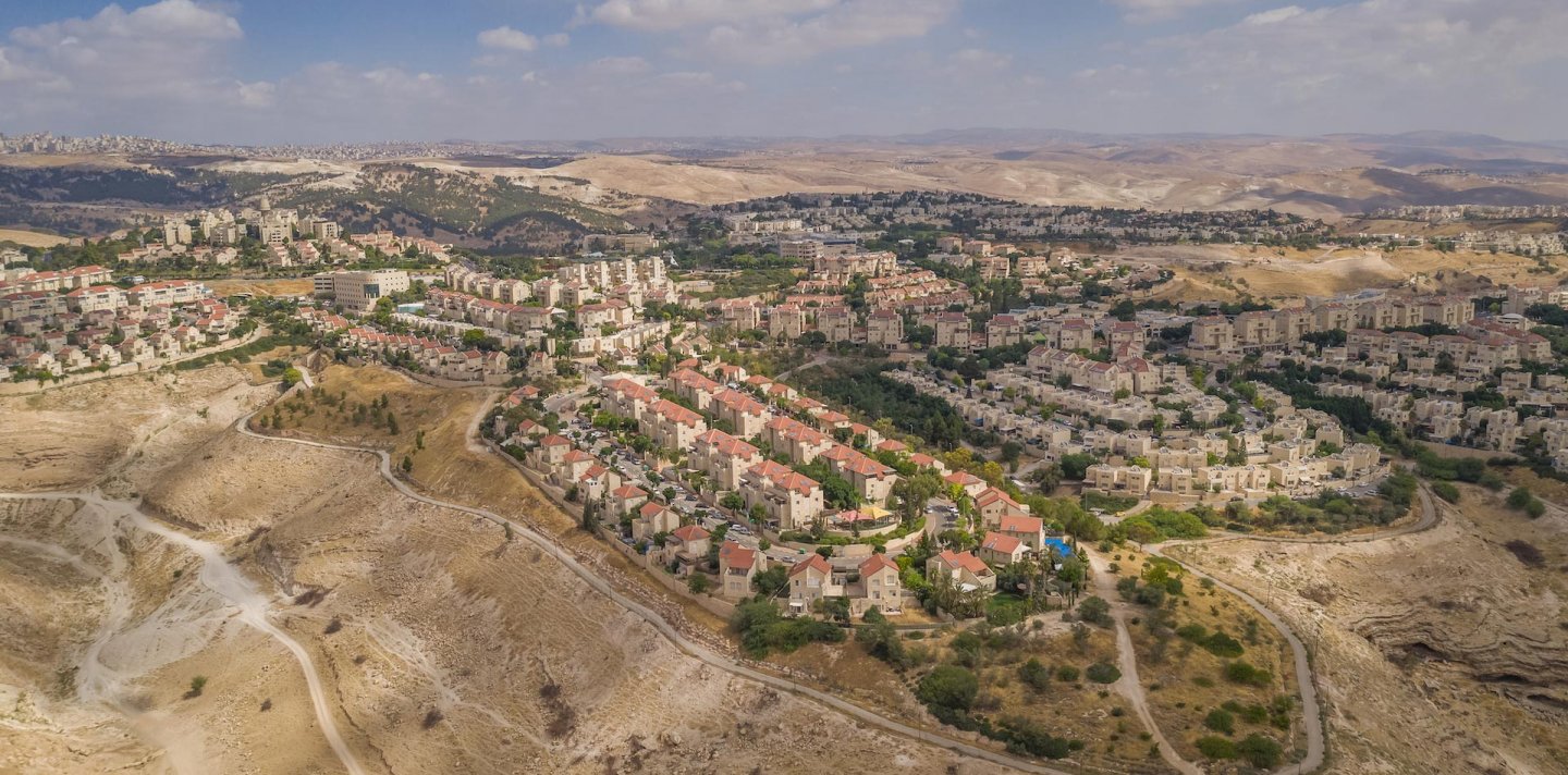
Israel’s Vision of a Greater [Jewish] Jerusalem
Snapshot
Throughout the years, the boundaries of the city of Jerusalem have changed and shifted along with various social, economic, and political transformations that occurred in the city and the region. To this day, the question of where the borders of Jerusalem lie is still a complex one to answer, as there are no agreed-upon definitions regarding the limits of the city. This ambiguity is constantly exploited by the State of Israel, which controls the whole region. While Israel officially draws the boundaries of Jerusalem along the 126 km sq area that includes occupied East Jerusalem, it constantly seeks to expand its control in the broader Jerusalem region.
“Greater Jerusalem” refers to the 440 km sq region encompassing Jerusalem and its suburbs, which Israel mostly controls through Jewish settlements, and which it is planning to incorporate into the city’s official boundaries.1 Seventy-five percent of the area of “Greater Jerusalem” lies within territories occupied in 1967,2 which includes, in addition to Israeli municipal Jerusalem, three major settlements or settlement blocs, to the east, south, and north of the city, respectively, each with its own regional and local self-government (separate from the city):
- Ma‘ale Adumim (a settlement)
- Gush Etzion (a bloc of 19 settlements)
- Giv’at Ze’ev (a settlement)
These settlements, constructed on confiscated Palestinian public and private lands, are constantly being expanded, developed, and connected to the urban core through bypass roads—most of which are inaccessible to Palestinians with Palestinian Authority (PA) IDs—as well as to one another to form a coherent “Greater Jewish Jerusalem.”
“Metropolitan Jerusalem” refers to the 1,000 km sq planning region encompassing Jerusalem and its suburbs and hinterlands, including the Ramallah region in the north and the Bethlehem and Hebron region in the south. Like “Greater Jerusalem,” “Metropolitan Jerusalem” is a planning area where Israel is developing and connecting rural Jewish settlements and satellite settlements to the urban core as well as to one another following various “master plans” that utilize the engineering of housing, public space, roads, and more to that end.3 The envisioned metropolitan region stretches from Mitzpe Yeriho west of the Jordan River to Beit Shemesh halfway toward the western coastal plain, and from the settlement of Ofra north of Ramallah to the Gush Etzion bloc and the satellite settlements in its vicinity south of Bethlehem (e.g., Efrat).4
Background
After Israel occupied the West Bank (including East Jerusalem) in June 1967, the state immediately unilaterally expanded the municipal boundaries on the city’s eastern side, integrating 28 Palestinian towns and villages that had formerly been outside the city into its administrative sphere (see Where Is Jerusalem? The Uncertain and Unfixed Boundaries of the City).
Israel also immediately began building Jewish settlements within the expanded municipal area and beyond it. These settlements were then expanded and eventually linked to Jerusalem through a broad network of bypass roads, crawling into the east, north, and south of Jerusalem, and forming several independent settlement jurisdictions (councils, regional councils, and even municipalities) while rupturing the geographical contiguity that had existed for centuries among Palestinian communities (see Settlements).
Subsequently, in 2002, Israel began building a massive Separation Wall whose route enveloped the Jewish settlements built deep in the occupied West Bank into a “Greater Jerusalem” region, while at the same time fragmenting and isolating areas of Palestinian settlement and excising Palestinian neighborhoods from the city5 (see The Separation Wall).
While these territorial and demographic transformations are meant to create immutable “facts on the ground” and amount to de facto annexation, legislative actions taken by the state over the last 54 years regarding the jurisdictional boundaries of Jerusalem served to make Israel’s annexation of territory de jure:
- In 1980, the “Basic Law: Jerusalem, Capital of Israel” declared the annexed areas of East Jerusalem inseparable from the State of Israel and established that no authority over the city in its municipal boundaries could be transferred to any foreign body without the passage of another Basic Law, which would require a majority of votes in the Knesset. This made it very hard for any future government to cede those territories.6
- This was followed by multiple minor expansions of municipal jurisdictional boundaries that were demographically oriented to artificially maintain a Jewish majority in light of the rate of demographic growth among Palestinians, trends which the state viewed with alarm as being existentially threatening.7
- Recently, Israeli leaders began taking steps toward further expanding municipal jurisdiction through a new set of constitutional amendments in contravention to international law.
The 2017 “Jerusalem and Her Daughters Bill” (aka the “Greater Jerusalem Bill”) was the latest attempt at the exponential expansion of Jerusalem’s Israeli municipal jurisdiction and the demographic reengineering of the city. Drafted and proposed to the Knesset by right-wing Israeli politicians in 2017, the bill outlined a plan to annex the major settlement blocs in the “Greater Jerusalem” region (Gush Etzion, Ma‘ale Adumim, E-1, and Givat Ze’ev) and grant them the status of “daughter municipalities,” while downgrading the status of Palestinian exclave neighborhoods beyond the wall such as Kufr ‘Aqab and Shu‘fat refugee camp such that they would no longer be served by the Jerusalem municipality or eligible to vote for it. Following some pressure by the US government later in the year, the plan was withdrawn and postponed;8 however, the “Jerusalem and Her Daughters Bill” is indicative of the broader geopolitical logic through which Israel is operating in the region, which aims at cementing an artificial Jewish demographic majority through a process that simultaneously absorbs Israeli settlements and settlers, on the one hand, as it fragments and excludes Palestinian communities, on the other.9 (See more on this plan below.)
Ultimately, these practices of de facto and de jure expansion by the state are aimed at establishing a “Greater Jerusalem” where Israeli control is absolute and exclusive,10 and where Palestinian presence is minimized and wholly controlled, and Palestinians are compliant, invisible, rightless, and voiceless.
De Facto Expansion: Expanding Jerusalem through Creating Facts on the Ground
Settlements
Directly following the 1967 War, Israel invested heavily in the settlement enterprise in East Jerusalem and the surrounding area. Over time, Israel has built up a network of concentric settlement belts that encircled and enveloped Jerusalem. These settlements, built mostly on expropriated Palestinian lands, stretch all the way to the Jordan River to the East, the Bethlehem and Hebron region to the south, and the Ramallah region in the north. The settlements in the vicinity of Jerusalem host the largest population of settlers in all of the occupied West Bank (half of the West Bank settler population in fact—see Settlements).11
Settlements were organized according to geostrategic plans12 bent on enlarging the territory that Israel controls13 through artificially cementing a demographic Jewish majority and preventing Arab growth in the region. Indeed, multiple settlement master plans were produced from the 1970s until today that consistently prioritized expanding and connecting Jerusalem settlements through bypass roads, while simultaneously preventing the creation of contiguous Arab populated areas, in accordance with a vision of a “Greater Jerusalem.” Among these are the Allon Plan of 1967, the Sharon Plan of 1977,14 and the Drobless Plan of 1978.15 Along with bypass roads that connect Israeli settlements across the land while confiscating and fragmenting Palestinian spaces,16 Israel is clearly forming a coherent and contiguous Jewish metropolitan region which amounts to the de facto annexation of territories in the “Greater Jerusalem” region.
Settlement planning over the years followed a certain logic that connects the metropolitan core to its immediate and broader surrounding of Israeli Jewish settlement. Looking at the map of settlements, one can follow this logic where a settlement is established and expanded into other settlements to create rings, and then a network of roads connects these blocs together. The innermost core comprises Jewish settlements inside the Old City (the Jewish Quarter), just outside of which are settlements within Arab neighborhoods that surround the Old City (or the so-called holy basin) in Silwan, Sheikh Jarrah, and Wadi al-Joz; followed next by the “inner ring or belt,” which consists of “settlement neighborhoods” within the municipal boundaries, followed by the “outer ring or belt” in the suburban Palestinian Jerusalem governorate, including Ma‘ale Adumim, Kokhav Ya’akov, Giv’at Ze’ev, Har Adar, Gush Etzion, and others, in addition to satellite settlements at a distance from the metropolitan core yet connected to it through bypass roads. For instance, Road 60 connects the settlements northeast of Ramallah (the so-called fourth settlement bloc)17 made up of Bet El, Psagot, and Kochav Ya’acov to the core of Jerusalem. The Gush Etzion settlements and settlements north of Hebron (e.g., Efrat settlement) in the south are also connected through a tunnel road (also Highway 60) built on Palestinian lands, separating Palestinian localities in the Bethlehem region.
Indeed, as the establishment and placement of these settlements creates territorial and demographic continuity and dominance for Jewish settlers, it simultaneously also surrounds and chokes Palestinian localities, infiltrates between them, blocks and prevents their natural growth, and fragments continuity between them. Plans to develop settlements and connect them with one another almost always comes at the cost of isolating, suffocating, and separating Palestinian localities that happen to be in the vicinity.
The E-1 Development Plan
Since the 1990s and the implementation of the Oslo Accords, more master plans have been produced aimed at completing the infrastructure for a “Greater Jewish Jerusalem.”18 The most recent and controversial of these is known as the E-1 Development Plan. The E-1 planning zone covers a 12 km sq area of unsettled land corridor in the West Bank that exists between the Ma‘ale Adumim settlement and Israeli municipal Jerusalem. The plan envisions a large commercial and industrial area with a new Israeli neighborhood called Mevasseret Adumim, an airport, hotels, tourist destinations,19 major roads, and a major district police station built on 180 dunams of land, which was already completed in 2008.20
While the E-1 plan seeks to connect and create demographic, territorial, and transportational contiguity between Ma‘ale Adumim and the rest of Jerusalem, it blocks the potential for Palestinian towns in the area to develop, since the so-called E-1 zone comprises the last open space available to Palestinian suburbs such as al-‘Izariyya and Abu Dis,21 the residents of whom privately own a significant part of the area.22 The creation of such Israeli continuity disconnects and further isolates these towns, which have Ma‘ale Adumim to their east and the Separation Wall to their west.
The implementation of this plan will complete the merging of a “Greater Jewish Jerusalem,” while completely cutting off the southern part of the West Bank from its northern part. It will block the roads between Ramallah and Bethlehem, making it impossible for Palestinians to travel from the north to the south and vice versa.
For this reason, international pressure has been put on the state since the 1990s not to go forward with the plan. The blueprint for E-1 is, however, still on the agenda, as Israel is finding ways to bypass constraints on its construction.23
The Separation Wall
The Separation Wall, which Israel began building in 2002, completely disconnected Palestinian spaces from one another and destroyed the idea of an Arab metropolitan Jerusalem while encompassing the major settlement blocs surrounding Jerusalem and hence establishing “the basis for the creation of a ‘Greater Jewish Jerusalem.’”24
The route of the Separation Wall participates in constructing this vision of a “Greater Jerusalem” as it encloses the main settlement blocs, while it excludes Palestinian neighborhoods and localities.25 The initiative was implemented by fences that expanded even more the boundaries of the city, while leaving many of the Palestinians trapped inside internal fences that disconnect them from the surrounding areas.26
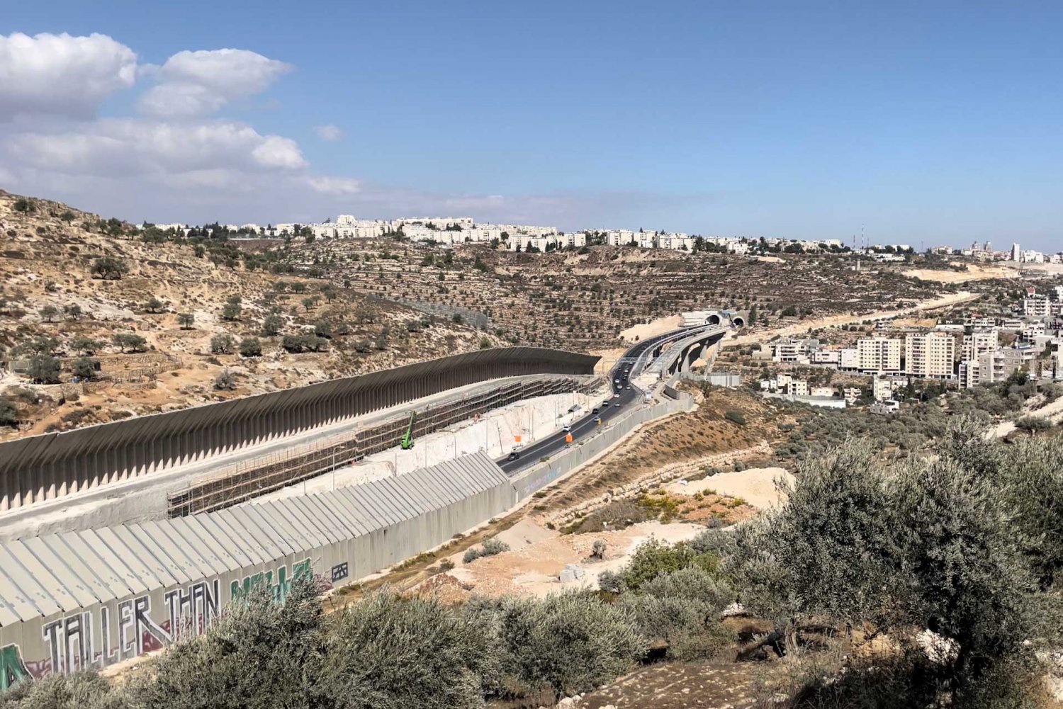
Highway 60 (The Tunnels Road) is an Israeli-only road that connects settlements south of Jerusalem to the city, bypassing Palestinian areas, as shown here in October, 2021.
Credit:
Sari Hammouri for Jerusalem Story
The wall completely fragments the continuous Arab makeup of the region by cutting off Palestinians in the West Bank from access to the city, cutting off East Jerusalem Palestinian suburbs from the city and from neighboring towns, (e.g., al-‘Izariyya and Silwan), and completely encircling Palestinian towns and villages, isolating them from their surroundings (e.g., Bir Nabala) (see The Separation Wall).
It is clear that the so-called “Jerusalem Envelope” encloses the settlement blocs that surround the city of Jerusalem such as Ma‘ale Adumim, Giv’at Ze’ev, and Gush Etzion, although they lie outside the borders of the Jerusalem municipality, while at the same time, the wall outright cuts off Palestinian areas, even those that are within the municipal boundaries, such as Kufr ‘Aqab and Qalandiya refugee camp in the north and Shu‘fat refugee camp to the East. Palestinians living within these neighborhoods pay taxes to the municipality and have long been an integral part of the city’s economy and society, while they have received almost no basic services from the municipality for a decade or more.
As should by now be clear, all these processes of territorial transformation, while they serve to bring about the infrastructure for a “Greater (Jewish) Jerusalem,” extinguish the possible emergence of a Palestinian capital and metropolitan region.
Case Study
The Fragmentation of Jerusalem’s Eastern Palestinian Towns
Jerusalem’s eastern Palestinian towns, including al-‘Izariyya and Abu Dis, have been completely separated from one another and from Jerusalem by the Separation Wall.
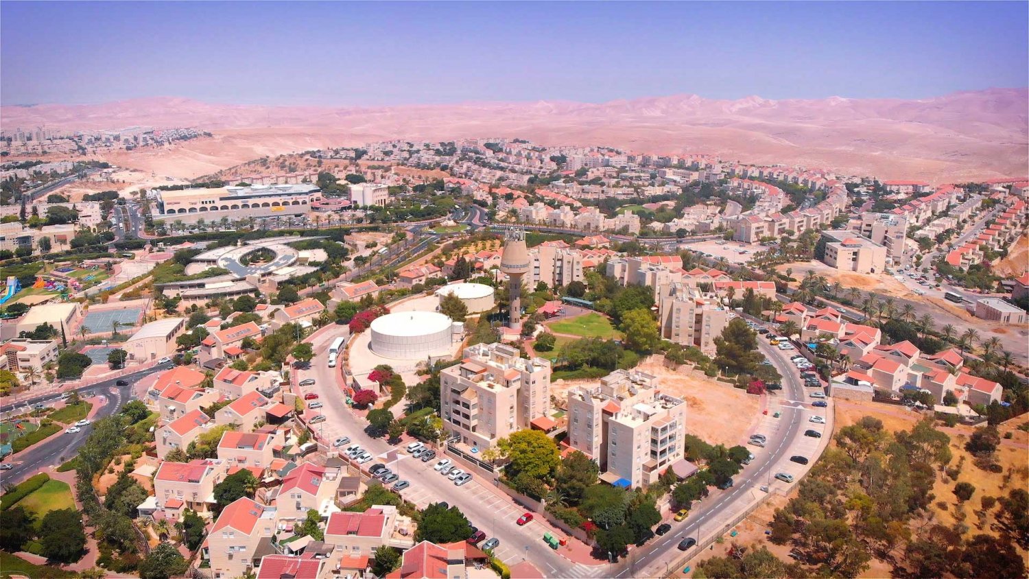
The settlement of Ma‘ale Adumim, which began around March 1975 when 40 members of the settlement movement Gush Emunim built a water tower and prefab concrete hut on the site, achieved city status in 1991 and is today a major city with a population of nearly 40,000. It lies 4.3 miles east of Jerusalem.
Credit:
Shutterstock
Continuing forward, Israel has presented numerous plans of expansion of the new local boundaries while maintaining demographic balance. It is important to see how the “Greater Jerusalem” strategy is being implemented at the scale of specific locations of Israeli control around Jerusalem. The Gush Etzion settlement bloc, for instance, has imposed a new demographic and geographical reality in the Bethlehem region.27
Most actively among the other fronts, Israel is intensifying its settlement enterprise in the south, where it is planning for new settlements such as Giv’at Hamatos and Har Homa E.28 In addition to the ramifications mentioned above, this project grants Israel what Jeff Halper, an Israeli American anthropologist and activist in Jerusalem, calls a “Matrix of Control”29—even over areas that are allocated, according to the Oslo Accords, to Palestinian control (i.e., Area A). This is achieved by building and expanding settlements that surround and cut off the Palestinian areas such as the central Ramallah–al-Bira region, for instance, as they become more and more connected to the Jerusalem metropolitan core as part of a network of Israeli-only roads, walls, and settlements that make up “Greater Jerusalem.”30
Case Study
The Destruction of ‘Anata and Bir Nabala
The wall destroyed the towns of ‘Anata and Bir Nabala by blocking their residents and severing them from their surroundings.
De jure Expansion: Expanding Jerusalem through Legislative Practices
Changes in the jurisdictional boundaries of the city of Jerusalem on the governmental level have long served as a political tool for gerrymandering. As early as 1931, the British Mandate authorities drew the city boundaries in a way that incorporated newly settled Jewish estates to the west of the city while excluding indigenous and historic Palestinian localities to the east and south of the city (e.g., Silwan), tilting the demographic balance towards the Jewish residents31 (see Where Is Jerusalem?).
In 1948, with the occupation of the western part of the city, Israel incorporated 84 percent of the municipal surface area of Jerusalem (according to 1931 Mandate municipal lines), which amounted to 16.26 km sq (including an enclave in the Jordanian-held eastern side).32 Post-statehood, Israel expanded the city’s boundaries to the west, doubling the size of the jurisdictional area to 38.11 km sq, and declared the city as the new country’s official capital in 1950.33
In 1967, after occupying the eastern side of the city, a committee of experts was set up by the prime minister that weighed multiple options regarding the borders of Jerusalem.34 Multiple approaches to the expansion were surveyed, whereby members of the committee planned it in such a way as “not to include too many Arab residents in the annexed area, and to include open areas for the development of Jewish neighborhoods.”35 Ultimately, the 70.1 km sq area around the then-larger East Jerusalem region was to be brought under the jurisdiction of the Jerusalem municipality.
Multiple border expansions followed, most of which incorporated the territory to the west of Jerusalem (mindful that the west side of the city was ethnically cleansed in 1948 and remained exclusively Jewish) and functioned to maintain Jewish demographic dominance within municipal lines, especially since demographic trends were in favor of Palestinians.36 The two expansions westward (0.5 km sq in 1985; 17.9 km sq in 1993) followed this logic. These brought the area of the Jerusalem municipality to its present size: 126.4 km sq37 (see Where Is Jerusalem?).
It is important to stress that while the Jerusalem municipal boundaries extend over a part of the region, the absolute majority of the rest of the region is Area C (90.4 percent), which means that it is under complete Israeli rule. Only some of the areas like Abu Dis and al-‘Izariyya are considered Area B (8.4 percent), and only a very small amount of that area is Area A (0.2 percent).38
Thirteen years after the 1967 occupation, on July 30, 1980, the “Basic Law: Jerusalem, Capital of Israel” was passed, which cemented political control over both parts of the city as it stated that “Jerusalem, complete and united, is the capital of Israel,” and prohibited any future government from transferring the territory.39
The “Greater Jerusalem” Concept Takes Shape
Although the concept had been floated and discussed from the outset of the occupation of East Jerusalem in 1967, during the 1990s, a specific concept of a “Greater Jerusalem” began to take clearer shape, one that sought to include the now populous and thriving settlement blocs that surrounded Jerusalem and to exclude as many Palestinian residents as possible.40 Especially since Israel did not want to lose its hold on the Jerusalem region and as Jerusalem became a controversial subject during the negotiations between Israel and the Palestine Liberation Organization (PLO) during the Oslo Accords in the early 1990s, Ehud Barak had proposed to hand over some Arab neighborhoods to the PLO to serve as the capital of Palestine, while Israel would annex the major settlements that surrounded Jerusalem. This proposal was rejected, not only by the Palestinians but also by most Israeli politicians, who were against any concession on Jerusalem’s territory.
With time, the idea that the Israeli government would give up any part of Jerusalem became less and less feasible. Barak later retracted, and as he said in an interview following the ultimate final failure of the negotiations in 2000: “I will not agree to give up the strengthening of Israel and the bolstering of greater Jerusalem, with a solid Jewish majority, for future generations.”41
The Jerusalem Basic Law of 1980 was amended twice, once in 2000 and a second time in 2014, and made concession on the territory even more impossible.42 The next amendment was proposed in 2017 and passed in 2018; led by right-wing politicians Naftali Bennet and Ze’ev Elkin, it further prevented “territorial compromise” while at the same time allowing “municipal changes,” which opened up the space to reevaluate the place of Palestinian neighborhoods that fall beyond the wall but within the municipal boundaries. As a 2018 report by Ir Amim states:
The legal distinction between “territorial concessions” and “municipal changes” is intended to create maximum room for manoeuvre in service to the goal of de facto annexation of the three settlement blocs surrounding Jerusalem, under the guise of “urban” expansion and in order to cut off the Palestinian neighbourhoods from the Jerusalem Municipality without formally waiving Israeli control and sovereignty over them.43
This amendment thereby paved the way for legislative proposals to expand the borders eastwards while excluding populous Palestinian spaces in the same area, without conceding sovereignty to the PLO.
“Greater Jerusalem Bill”: Some Daughters Are More Wanted than Others
On July 10, 2017, in the midst of new settlement expansions in Jerusalem and a wave of residency revocations, the “Greater Jerusalem Bill” was first introduced in the Knesset by MKs Yoav Kisch and Yisrael Katz (both from the Likud Party).
When the bill was first drafted in March of the same year, it stipulated that the Gush Etzion regional council, the Beitar Illit and Ma’ale Adumim municipalities, the Giv’at Ze’ev and Efrat local councils,44 “will be annexed to Israel and will be part of Jerusalem.”45 The final draft submitted in July, however, omitted the phrase “annexed to Israel” but maintained the settlements will be included to the city.46 The implementation of the bill would be tantamount to annexing 19 Jewish settlements to Jerusalem and would create a larger metropolitan Jerusalem analogous to metropolitan London.47 The plan aims to grant these (Jewish) settlements the additional status of Jerusalem sub-municipalities (or “daughter municipalities”) and to synchronize their electoral calendars with Jerusalem municipal elections. In short, when all is said and done, the Jewish residents of these settlements would retain their autonomy, voting in their own local councils, in addition to voting in Jerusalem municipal elections. Given that there are about 360,00048 Palestinians in Jerusalem who are qualified to vote, this would ensure a Jewish majority vote and a lock on political control over the city’s fate, virtually in perpetuity. In the words of Yoav Kisch himself, the new political arrangement would serve “to strengthen the Jewish majority in Jerusalem, with 150 thousand Jews who will vote for metropolitan Jerusalem.”49 Once these settlements become “sub-municipalities,” they would continue to enjoy “municipal autonomy”50 while exercising their newly conferred electoral power in Jerusalem.
But the bill would not stop there. The bill would also set up a second category of sub-municipalities of Jerusalem, albeit with a different fate: This fate is allocated to the “Jerusalem neighborhoods separated from it by means of the Separation Barrier,” that is, the Palestinian neighborhoods inside the municipal boundaries but left outside the wall—Kufr ‘Aqab, ‘Anata, and Shu‘fat refugee camp are the ones specified in the bill. Under the proposed plan, these wholly Palestinian neighborhoods would become “daughter municipalities” as well. But these daughters would not be like the others.
It is not defined in the law itself whether these neighborhoods would receive any sort of privileges, services, or resources such as the ones that the bill would guarantee to the Jewish “daughter municipalities.” This subject is left for the specific consideration of the Jerusalem municipality, which since the erection of the wall has completely marginalized and neglected these localities, even their most basic needs related to infrastructure, sanitation, education, urban planning, and more.
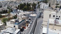
The Palestinian neighborhood of Kufr ‘Aqab, an abandoned exclave that lies outside the wall but within the Israeli municipal boundaries
Credit:
Samer Sharif
While the bill was blocked at the last minute by US intervention, it remains alive on the Knesset agenda and will soon resurface. Should it pass, the impact on the Palestinian neighborhoods beyond the wall would be drastic and devastating. These neighborhoods house one-third of the Palestinians who live in municipal Jerusalem. Unlike the separate Jewish settlement blocs that are completely self-reliant with full resources allocated directly by the government,51 these neighborhoods are reliant on the city for income and resources, and are connected to it by identity, community life, and family ties. In addition, in contrast to the independent Israeli settlements around Jerusalem, the residents of the neighborhoods beyond the wall have continued to pay taxes to the municipality since 1967 without receiving basic services.52
The walled refugee camp of Shu‘fat in Jerusalem, The Funambulist, July 25, 2017
Credit:
Léopold Lambert via The Funambulist
It is clear that the bill seeks to set apart two “daughters”: One it sets out to incorporate and enfranchise; the other it aims to excise and disenfranchise. Indeed, MK Katz himself proclaimed that the aim of the bill was to “to strengthen Jerusalem by adding thousands of Jewish residents to the city and simultaneously weakening the Arab hold on the capital.”53
Other plans have sought to cut out or downgrade the status of these Palestinian neighborhoods beyond the wall even before the bill was presented to the Knesset; some have advocated handing them over to the PA.54 But the “Greater Jerusalem Bill” would not do that. Rather, it would force the residents (already split off from the city by the wall) to somehow manage to administer their own affairs, without any support from the municipality, while remaining within the municipal boundaries and the State of Israel.
Advocates of this solution have voiced arguments in support. For example, a piece published by the Israeli Jerusalem Centre for Public Affairs in 2018 described why getting rid of neighborhoods beyond the wall without handing over their territory to the PA could be “good for Israel”:
The plan is good for Israel. It will remove about one-third of the Arab population from the city so that the Jewish share of the population will come to 69 percent instead of 59 percent at present. The City of Jerusalem will free itself from an economic burden, one that it could not contend with even before the building of the fence. Unlike other plans for the division, such as Haim Ramon’s plan, the territory will not be transferred to the Palestinian Authority, neither all at once nor gradually. Israel will not lose intelligence accessibility and preventive and operational capabilities within these neighborhoods, thereby averting a potential threat. Such a threat materialized in the past when Israel transferred the Beit Jala area to the PA, and the adjacent Gilo neighborhood came under fire for years.55
As Knesset Member Kisch said, “The Greater Jerusalem Bill is an extremely important bill,” adding that it “enshrines Jerusalem’s status as the eternal capital of the people of Israel and the Jewish majority in the capital.”56
On October 29, 2017, the Knesset Ministerial Committee on legislation was poised to approve this bill and send it to the Knesset for its first reading when the US embassy intervened and pressured the government against passing the law. Twelve hours before it went to the floor, the bill, which “would likely have garnered a majority of support,” was “blocked indefinitely” by the prime minister.57 The bill was only delayed, and Israeli politicians are still trying to get the bill passed.58
What followed the US administration’s demand to halt the bill, however, was not an attempt by the US to curb Israeli efforts at consolidating control over Jerusalem, or pressure to guarantee the rights of its Palestinian residents. Rather, later in that year, the US government, in contravention to international law, officially recognized Jerusalem as the capital of the State of Israel and relocated its embassy to the city.59 Later in 2020, the Trump administration even drew up a “peace plan” that asserts that grants Israel sovereignty over East Jerusalem, including the major settlements in the surrounding region, while it cuts off the Shu‘fat refugee camp and Kufr ‘Aqab from the city,60 in accordance with the expansionist and exclusionary “Greater Jerusalem” vision.
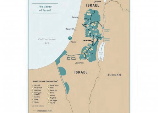
Jerusalem according to the Deal of the Century
Credit:
“Peace to Prosperity: A Vision to Improve the Lives of the Palestinian and Israeli People,” United Nations, January 28, 2020, Appendix 1: Conceptual Maps, 41
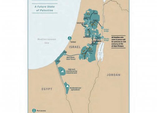
Jerusalem according to the Deal of the Century
Credit:
“Peace to Prosperity: A Vision to Improve the Lives of the Palestinian and Israeli People,” United Nations, January 28, 2020, Appendix 1: Conceptual Maps, 41
Conclusion
The growing settlement enterprise in and around East Jerusalem, along with the construction of Israeli-only roads and the Separation Wall, were all put in place as part of consecutive politically motivated geostrategic plans meant to cement the infrastructure for a vision of an Israeli-controlled “Greater Jerusalem” and a broader “Metropolitan Jerusalem” where Palestinian presence is as minimal as possible and where existing Palestinian communities are fragmented, isolated, stunted, and powerless.
While the vision for a “Greater Jerusalem” is about the expansion of the area of Israeli control around Jerusalem, it is accompanied by the outright excision and exclusion of whole neighborhoods where Palestinians live. Indeed, as we can see, the vision for a “Greater Jerusalem” is accompanied by the captivation of Arab villages and towns in the area and suppression of land growth, disintegration of territorial continuity between neighboring Palestinian villages and neighborhoods, the dismantlement of the possibility for a Palestinian capital61 and a metropolitan center that hosts the largest Palestinian demographic presence in all of historic Palestine (the Ramallah, Jerusalem, Bethlehem, metropolitan continuum) and ultimately through creating a core Jerusalem region that is completely inaccessible to Palestinians with PA IDs,62 and the division of the West Bank as a whole into north and south.
The Israeli state has long attempted to expand its territories, beyond its 1948 borders, into the areas it occupies and where it aims to establish Jewish political sovereignty. In the Zionist political imagination, these expansionist ambitions are not restricted to Jerusalem, but to the whole geography of historic Palestine and beyond it, based on an imperial biblically based vision of a “Greater Israel” that expands into the eastern bank of the Jordan River, where currently the country of Jordan lies, and extends from the Egyptian Nile onto the Syrian Euphrates.63
Today Israel already has de facto close to complete control over the region it defines as “Greater Jerusalem.” In addition, the presence of these settlements is becoming more and more normalized as international pressure is proving to be less and less effective, especially after Trump’s recognition of Jerusalem as the capital of Israel, which the administration that came after Trump did not rescind.64
Driven by a vision of a greater Israeli-controlled Jerusalem, through the expansion of regional settlements, Israel is advancing the process of annexation of occupied Palestinian lands in complete contravention to international law.65 These de facto expansions were accompanied by recent attempts to annex more territory and legally incorporate it into the municipal jurisdictional area.
Contributors
Researcher and Writer: Amir Marshi, Jerusalem Story
Editor: Kate Rouhana, Jerusalem Story
Notes
1
450 km sq with 75 percent of the area within territories occupied in 1967 according to Jan De Jong, “Israel’s ‘Greater Jerusalem’ Engulfs the West Bank’s Core,” Jerusalem Quarterly file (1997); 47.100 sq miles (about 160 km sq) according to “‘Greater’ Jerusalem Area,” United Nations Digital Library, accessed January 28, 2021; and “Jerusalem: ‘Greater’ Jerusalem,” Jewish Virtual Library.
2
Jan De Jong, “Israel’s ‘Greater Jerusalem,’” 47.
3
“Land Grab: Israel’s Settlement Policy in the West Bank,” B’Tselem, May 2002, 103.
4
Yair Assaf-Shapira, “Metropolitan Jerusalem,” Jerusalem Institute for Policy Research, August 31, 2014.
5
Francesco Chiodelli, “Re-shaping Jerusalem: The Transformation of Jerusalem’s Metropolitan Area by the Israeli Barrier,” Cities 31 (2013): 417.
6
“Jerusalem, Complete and Unified, Is the Capital of Israel,” in “Basic Law, Jerusalem, Capital of Israel,” The Knesset, Basic Laws, accessed January 28, 2021.
7
“Municipal Boundaries of Jerusalem, 1947–2000,” PASSIA.
8
Jeffrey Heller, “U.S. Pressure Delays Israel’s ‘Greater Jerusalem’ Bill: legislator,” Reuters, October 29, 2017; Shlomi Eldar, “US Pressure Kills ‘Greater Jerusalem Bill,’” Al-Monitor, October 30, 2017.
9
Yehudit Oppenheimer, Legislative Initiatives and Government Plans for Unilateral Policy Changes in the Borders of Jerusalem (Jerusalem: Ir Amim, March 2018).
10
The bill itself begins with the following statement: “Jerusalem has been the capital of Israel and the capital of the Jewish people [i.e., worldwide] for over three thousand years. Fifty years ago the city was liberated and reunited.” “The Jerusalem and Its Daughters Bill,” 2017.
11
According to 2017 data, if we supplant the number of settlers in Municipal Jerusalem (209,270) only with the three of the surrounding settlements of Beitar Illit (54,557), Ma‘ale Adumim (37,817), and Giv’at Ze’ev (17,323) we get 318,967, which is already more than half of West Bank settlers, the grand total of which in 2017 was 588,496. And this is without including the various other settlements and outposts in the region. “Statistics on Settlements and Settler Population,” B’Tselem, January 16, 2019.
12
“Settlement activities within and around Jerusalem has its geopolitical agenda. In addition to segregating the urban fabric within the city and turning the Palestinian built-up areas into enclaves, the agenda aimed at creating a Jewish urban belt around Palestinian East Jerusalem. This belt was shaped by the ring of settlements surrounding Jerusalem from all directions: Nof Yael (Northwest), Har Homa (south), Geva, Geva Binyamin (north), Givat Zeev, Agan HaAyalot (northwest), and Maale Adumim/E-1 (East; Figure 7).” Salem Thawaba and Hussein Al-Rimmawi, “Spatial Transformation of Jerusalem,” Journal of Planning History 12, no. 1 (2012): 70.
13
It was clear that early settlements in the East Jerusalem region were developed in connection with a vision for future expansion of an Israeli-controlled Jerusalem region. In 1974, for example, the governmental decision for the creation of an industrial area called Mishor Adumim spelled out a clear metropolitan logic: “The planning of the area will take into account Jerusalem’s municipal-industrial development needs, and will be carried out in coordination with the Jerusalem Municipality.” Cited in Bimkom and B’Tselem, The Hidden Agenda: The Establishment and Expansion Plans of Ma’ale Adumim and Their Human Rights Ramifications (Jerusalem: Bimkom-B’Tselem, 2009), 12.
14
“Land Grab,” 14–15.
15
Geoffrey Aronson, “Settlement Monitor,” Journal of Palestine Studies 27, no. 1 (1997): 126–27.
16
Hagar Shezaf, “Highways to Annexation: Across the West Bank, Israel Is Bulldozing a Bright Future for Jewish Settlers,” Haaretz, December 2020.
18
“The idea of planning the Jerusalem area as a metropolis was embodied in 1994 in a master plan prepared for the government by the Jerusalem Institute for Israel Studies. The master plan proposes guidelines for development for the area through the year 2010. Although the plan has no legal force and was never implemented it has, according to the State Attorney’s Office, served as a basis for planning the expansion of the settlement of Ma’ale Adumim to the west.” “Land Grab,” 102. “In 1995 the Israeli government adopted a master plan for a ‘Greater Jerusalem’ whose ‘outer ring’ of settlements—Har Adar, Givat Ze’ev, New Givon, Kiryat Sefer, Tel Zion and the settlements to the east of Ramallah, Ma’ale Adumim, Israeli building in Ra’s al-‘Amud, Efrat, the Etzion bloc and Beitar Illit—will virtually encircle the city. The outer ring’s population will grow to 250,000 in the next decade.” Jeff Halper, “The 94 Percent Solution,” Middle East Research and Information Project, 2000, 216.
19
“The E-1 Plan and Other Jerusalem Disasters: A Review of Israeli Settlements Underway,” Journal for Palestine Studies, no. 24 (2005): 33.
20
“The E-1 Development Plan,” PASSIA.
21
“The E-1 Plan and Other Jerusalem Disasters.”
22
“The E-1 Development Plan.”
23
“Road to Allow E1 Construction Is Being Promoted,” Peace Now, March 9, 2020.
24
Full quote: “As Klein (2005) maintains, the wall can establish what Jewish outposts alone were unable to achieve: to destroy the idea of an Arab metropolitan centre in East Jerusalem, establishing at the same time the basis for the creation of a ‘Greater Jewish Jerusalem’. In this sense, the construction of the barrier probably represents the most relevant transformation of the city since 1967 (Dumper, 2008; Shoval, 2007; Yiftachel & Yacobi, 2005).” Chiodelli, “Re-shaping Jerusalem,” 417.
26
Such as the villages of Bir Nabala, al-Jib, and Beit Hanina al-Balad in the vicinity of the settlement of Giv’at Ze’ev. See also Eyal Hareuveni, “Arrested Development: The Long-term Impact of Israel’s Separation Barrier in the West Bank,” B’Tselem, 2012, 43–45.
27
For more about Israel’s de facto and de jure past and future plans to annex Gush Etzion, see BADIL Resource Center for Palestinian Residency and Refugee Rights, Israeli Annexation: The Case of Etzion Colonial Bloc (Bethlehem: BADIL Resource Center for Palestinian Residency and Refugee Rights, 2019).
28
“Six-Month Report on Israeli Settlements in the Occupied West Bank, including East Jerusalem, Reporting Period January–July 2020,” Office of the European Union Representative, March 20, 2021.
29
Jeff Halper, The Key to Peace: Dismantling the Matrix of Control (London: ICAHD: The Israeli Committee Against House Demolitions, n.d.).
30
Halper, The Key to Peace.
31
In Jerusalem Unbound, Jerusalem expert Michael Dumper writes of the changes introduced by the British during the mandate, “What was controversial in these changes is a pattern that has been followed to this day . . . the designation of borders to defend or promote the interests of a particular ethnic or religious group in the city. The British borders swung in a wide arc west of the city to incorporate the new housing estates established by Jewish and Zionist settlers. In contrast, while large numbers of new settlers were being incorporated into the city limits, in the east the municipal borders slid between the walls of the city and the Palestinian villages virtually abutting the walls in order to exclude them. The prime intention of this blatant gerrymandering of the borders was to ensure an electoral advantage of the Jewish community of the city over its Palestinian residents.” Michael Dumper, Jerusalem Unbound: Geography, History, and the Future of the Holy City (New York: Columbia University Press, 2014), 56–57.
32
“Municipal Boundaries of Jerusalem, 1947–2000,” PASSIA.
33
“Municipal Boundaries of Jerusalem.”
34
Meron Benvenisti, City of Stone: The Hidden History of Jerusalem (Berkeley: University of California Press, 1996), 64–65.
35
Benvenisti writes that: “The Civilian members of the committee were concerned about the demographic ratio between Jews and Arabs that would be produced by excessive expansion of the city’s boundaries, and advised the cabinet ‘not to include too many Arab residents in the annexed area, and to include open areas for the development of Jewish neighborhoods.’” Benvenisti, City of Stone, 65.
36
1967: 74.2 percent Jewish—28.4 percent Palestinian (266,300 total); 1985: 71.6 percent Jewish—28.4 percent Palestinian (458,100 total); 1998: 68.4 percent Jewish—31.6 percent Palestinian (633,700 total). “Municipal Boundaries of Jerusalem.”
37
“Municipal Boundaries of Jerusalem.”
38
The figures are from Rassem Khamaisi, “Shrinking the Palestinian Space,” under development by Jerusalem Story.
39
“No authority that is stipulated in the law of the State of Israel or of the Jerusalem Municipality may be transferred either permanently or for an allotted period of time to a foreign body, whether political, governmental or to any other similar type of foreign body.” “Basic Law – Jerusalem Capital of Israel – English Text,” The Israeli-Palestinian Conflict: An Interactive Database.
40
“Destructive Unilateral Measures to Redraw the Borders of Jerusalem,” Ir Amim, January 25, 2018, 4.
41
“Statement by PM Barak on Conclusion of the Camp David Summit-July 25-2000,” Israel Ministry of Foreign Affairs, July 25, 2000.
42
“In 2000, the Basic Law: Jerusalem, Capital of Israel was amended to further restrict any possibility of future negotiations regarding the city. The new sections clarified that the law applies to the entire area annexed in 1967 (section 5) and that no area of Jerusalem within the borders of the annexation could be transferred to any foreign entity or authority (section 6). The law further provided (section 7) that in order to amend the new provisions, it would be necessary to pass a Basic Law by a majority of at least 61 members of the Knesset. Beyond the sweeping prohibition on transferring territory from Jerusalem set out in the amendment to Basic Law: Jerusalem, Capital of Israel, the Knesset passed the Basic Law: Referendum in 2014. This law presents two alternatives for ratifying any government decision that entails, by diplomatic accord or unilateral act, ceding Israeli sovereign territory: 1) approval of the agreement by a majority of 61 MKs along with a majority of voters in a referendum; or 2) approval of the agreement by a majority of 80 MKs, without need for a referendum. The Basic Law: Referendum was designated as a protected law that can only by changed through a basic law approved by 61 MKs.” Oppenheimer, “Destructive Unilateral Measures,” 8.
43
“Destructive Unilateral Measures to Redraw the Borders of Jerusalem,” 9.
44
Israel has three kinds of local authorities: municipal council—a local authority that has the status of a city; local council—a local authority that is not large enough to have the status of a city; regional council—a local authority of several settlements, usually rural. In the case of the Gush Etzion regional council, it includes 24 settlements located southeast of Jerusalem. See the Gush Etzion official regional council website.
45
The Jerusalem and Her Daughters Bill, 5757-2017 (P/4109/20).
46
The Jerusalem and Her Daughters Bill, 5777-2017 (P/4386/20).
47
Tovah Lazrof, “Netanyahu Backs Greater Jerusalem Bill That Would Annex 19 Settlements,” Jerusalem Post, October 3, 2017.
48
“Localities and Other Geographical Divisions,” Israeli Central Bureau of Statistics.
49
“Channel 20—Interview with MK Yoav Kish on the Greater Jerusalem Law” [in Hebrew], YouTube, December 3, 2017.
50
The Jerusalem and Her Daughters Bill (P/4386/20).
51
Israel has three kinds of local authorities: municipal council—a local authority that has the status of a city; local council—a local authority that is not large enough to have the status of a city; regional council—a local authority of several settlements, usually rural. In the case of the Gush Etzion regional council, it includes 24 settlements located southeast of Jerusalem. See the Gush Etzion official regional council website.
52
The Jerusalem and Her Daughters Bill, 5757-2017 (P/4109/20).
53
The Jerusalem and Her Daughters Bill, 5777-2017 (P/4386/20).
54
Tovah Lazrof, “Netanyahu Backs Greater Jerusalem Bill That Would Annex 19 Settlements,” Jerusalem Post, October 3, 2017.
55
“Localities and Other Geographical Divisions,” Israeli Central Bureau of Statistics.
56
“Channel 20—Interview with MK Yoav Kish on the Greater Jerusalem Law” [in Hebrew], YouTube, December 3, 2017.
57
The Jerusalem and Her Daughters Bill (P/4386/20).
58
“Annexation Moves Intensify: Greater Jerusalem Bill Hits Ministerial Committee on Legislation on Sunday,” Ir Amim, October 26, 2017.
59
“Annexation Moves Intensify.”
60
“Annexation Moves Intensify.”
61
“Destructive Unilateral Measures,” 12.
62
Nadav Shargai, “A Jerusalem Solution: One Sovereignty, Multiple Local Authorities (including for the Arab Neighborhoods),” Jerusalem Center for Public Affairs.
63
Yasso Verter, "Israeli Ministers Set to Vote on Annexing West Bank Settlements to Jerusalem,” Haaretz, October 26, 2017.
64
Eldar, “US Pressure Kills ‘Greater Jerusalem Bill.’”
65
It was put on the Knesset table for discussion most recently in April 2020. The Jerusalem and Her Daughters Bill, 5742-2020 (P/82/23).
66
Noa Landau, Amir Tibon, and Reuters, “Trump Recognizes Jerusalem as Israeli Capital, Says Final Borders up to Israel, Palestinians,” Haaretz, December 7, 2017.
67
Nir Hasson, “Trump’s Plan Calls for ‘Sensitivity’ in Jerusalem: Then Takes a Hammer to It,” Haaretz, January 29, 2020.
68
Khalil Mabrouk, “Study: Jerusalem Is the Starting Point of Settlement Projects to Seize the West Bank” [in Arabic], Al Jazeera, March 4, 2021.
69
Aronson, “Settlement Monitor,” 126–27.
70
See Nur Masalha, Imperial Israel and the Palestinians: The Politics of Expansion (London: Pluto Press, 2000).
71
“US to Keep Embassy in Jerusalem: Biden’s Top Diplomat,” Al Jazeera, January 20, 2021.
72
See “Hague Convention (IV) Respecting the Laws and Customs of War on Land and Its Annex: Regulations Concerning the Laws and Customs of War on Land,” October 18, 1907; “Geneva Convention Relative to the Protection of Civilian Persons in Time of War (Fourth Geneva Convention),” August 12, 1949, 75 UNTS 287.