Overview: Forming an Expansionist Settlement Policy
Credit:
David Rubinger/Time & Life Pictures/Getty Images
The History of Israeli Settlement Expansion in and around East Jerusalem from 1967 to 1993
Snapshot
This Backgrounder addresses the early history of the Israeli settlement enterprise in Jerusalem since the occupation of the West Bank (including East Jerusalem) in 1967. It shows how the Israeli government’s policy of creating “facts on the ground” has consistently been steered toward the expansionist agenda of claiming “more territory with less Arabs.” The settlement of East Jerusalem and its environs is anchored by a planning regime that aims to envelop, expand, and connect Israeli settlements while fragmenting Palestinian communities and restricting Palestinian natural growth. Ultimately, settlements contribute to circumventing any future compromise on territory, as well as to the hyper-development of Israeli Jewish communities at the expense of Palestinian communities, which suffer from de-development, atrophy, and in some cases, outright extinction.
This Backgrounder shows how, between 1967 and 1993, Israel established its de facto annexation policy based on three interconnected geostrategic imperatives achieved by settlement expansion.
Since it occupied the West Bank, which includes East Jerusalem, in 1967, Israel has continued to implement the settler-colonial agenda that the Zionist movement pursued across historic Palestine since the late 19th century.1
Shortly after occupying East Jerusalem in 1967, Israel unilaterally extended its administrative and judicial control over a greatly expanded municipal area amounting to nearly 71 sq km (see Where Is Jerusalem?). This distinct legal and political reality meant that for the first decade of occupation, Israel had to construct and legitimize a new legal infrastructure and planning regime that would allow for the appropriation of land and the establishment of settlements within the expanded Israeli municipal boundaries of East Jerusalem, and in the remainder of the occupied territories surrounding it. The ultimate goal would be the consolidation of a Greater Jewish Jerusalem (see Israel’s Vision of a Greater [Jewish] Jerusalem).
These policies were put into practice despite the fact that they violated international law, as made clear by repeated international resolutions.2 In fact, settlement activity in and around Jerusalem consistently intensified over the years, serving to legitimize Israeli claims to sovereignty over those territories. This logic became known among Israeli politicians as the establishment of “facts on the ground.”3
Israel’s settlement policies were formed in different stages in accordance with different political, geopolitical, and international developments, reviewed briefly next.

Backgrounder
The Three Israeli Settlement Rings in and around East Jerusalem: Supplanting Palestinian Jerusalem
Israel’s settlements in and around Jerusalem take the shape of three rings that contribute to Judaizing the city and fragmenting its Palestinian communities.
Forming a Settlement Policy (1967 to 1977)
During the first decade, Israel did not have an officially agreed-upon plan or policy to settle the occupied West Bank (including East Jerusalem), only a fervent intention to do so.4 Moreover, before 1967, while Israel carried out planning and construction within its 1948 borders in a centralized, top-down process, post-occupation, the process was carried out by a combination of government and municipal institutions, as well as by para-state institutions and extra-governmental extremist settler movements.5
That said, settlement planning in the West Bank has not been arbitrary. Indeed, part of the success of the government’s settlement policy between 1967 and 1977 can be attributed to the very ambiguity regarding the authority over settlement policy. As Eyal Weitzman argues, this ambiguity “itself became an effective government strategy.” That is, the “appearance of being out of control allowed the state to achieve its ideological objectives without accepting responsibility for them.” This was aided by the fact that: “Whereas in the 1950s and early 1960s state planning was undertaken by professional architects and planners, after the 1967 war it was mainly undertaken by politicians, generals and ideological activists.”6
The geopolitical impact of unofficial “master plans” and acts of establishing “facts on the ground” during that time was long term and laid the foundations for later government settlement policy in the West Bank. Indeed, the policy of Israeli settlement expansion that began in 1967 continues to this day and has consistently been symbiotic with the fragmentation, ghettoization, and deprivation of Palestinian communities. That is, as will be shown in this Backgrounder, governmental and nongovernmental decisions to expand settlements in and around Jerusalem between 1967 and 1977, which were institutionalized during the following decade, formed a geopolitical policy followed to this day.
The policy is based on three interconnected political imperatives, reviewed next.
1. The demographic-territorial imperative: Israeli municipal planning
After the 1967 War, a committee of Israeli “experts” proposed multiple approaches for expansion into the newly occupied territory. Members of the committee planned it in such a way as “not to include too many Arab residents in the annexed area, and to include open areas for the development of Jewish neighborhoods.”7 While multiple Israeli officials were interested in annexing a sizable chunk of the Jerusalem region in accordance with the “Greater Jerusalem” vision, the government did not do so in order to avoid the inclusion of large Palestinian populations in those areas.8 The government justified the expansion on alleged “security concerns,” but expanding territorial control through an increase in Jewish presence was the main political imperative guiding municipal planning and construction of settlements.9
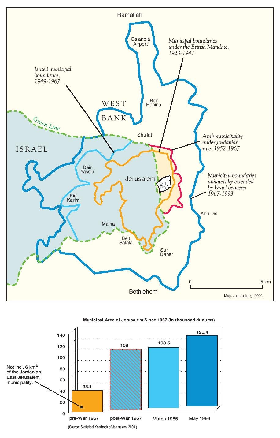
Municipal boundaries of Jerusalem 1947–2000, showing the expansion of Israeli jurisdiction over Arab East and West Jerusalem over time
Credit:
Indeed, in 1968, Teddy Kollek, mayor of Jerusalem between 1965 and 1993, said regarding the importance of Jewish settlement in Jerusalem: “The object is to ensure that all of Jerusalem remains forever a part of Israel. If this city is to be our capital, then we have to make it an integral part of our country, and we need Jewish inhabitants to do that.”10 The planning and construction of settlements in the Jerusalem area followed a demographic and political logic recommended in 1973 by the Inter-ministerial Committee to Examine the Rate of Development for Jerusalem (known as the “Gafni Committee”). The recommendation, which was adopted by the government and became the cornerstone of all subsequent municipal planning policy, was that a “demographic balance of Jews and Arabs must be maintained as it was at the end of 1972,” that is, 73.5 percent Jews, and 26.5 percent Palestinians.11 Teddy Kollek put it this way:
Israel saw the adoption of strict zoning plans as a way of limiting the number of new homes built in Arab neighborhoods, and thereby ensuring that the Arab percentage of the city’s population—28.8 percent in 1967—did not grow beyond this level . . . The idea was to move as many Jews as possible into east Jerusalem, and move as many Arabs as possible out of the city entirely. Israeli housing policy in east Jerusalem was all about this numbers game.12
This vision has persisted to this day. In other words, since 1967, Israeli settlement policy in Jerusalem has evolved in lockstep with this demographic imperative, and has been carried out with the confiscation of lands in and around the eastern half of the city and beyond.
From 1967 to 1977, the governing Labor party refrained from transferring Palestinian property directly to settlers except in the Jewish Quarter of the Old City.13 It did, however, lay the groundwork for this by applying the 1950 Absentees’ Property Law to East Jerusalem. It also immediately turned to land confiscations and settlement building, using, for the most part, the Public Good Law—the 1943 British Mandate Lands Order (Acquisition for Public Purposes)—which allowed the government to expropriate privately owned land within the municipal boundaries for “any need authorized by the Minister of Finance as public purpose.” The government was left to decide what constituted “public purpose.” This facilitated the construction of urban settlements in and around Jerusalem.14
At the same time as the municipality confiscated Palestinian lands, it put in place a planning regime to ensure the curbing of Palestinian growth and the reduction of Palestinian presence—i.e., the Judaization of the city. Half of the settlement neighborhoods existing today within the municipal boundaries (see The Three Israeli Settlement Rings in and around East Jerusalem: Supplanting Palestinian Jerusalem) were built between 1968 and 1973 on confiscated Palestinian land. This included the Jewish Quarter of the Old City, built on the confiscated waqf lands of the adjacent Moroccan Quarter, which was completely destroyed and its inhabitants forcibly expelled just days after the city was occupied in June 1967 in order to create the prayer plaza that exists today across from the Western Wall (see The Destruction of Jerusalem’s Moroccan Quarter: From Centuries-Old Maghrebi Community to Western Wall Prayer Plaza). Although most of these properties were not owned by Jews before 1948, in 1968, Israel used the Public Good Law as well as the Absentees’ Property Law to confiscate hundreds of dunums of land in the area in order to expand the Jewish Quarter as a Jewish settlement extending from the Western Wall to the Armenian Quarter, and from Bab al-Silsila in the north to the Old City’s southern wall.15 Nonetheless, the area still had a majority Palestinian population throughout the 1970s, which prompted the Israeli government, along with the Company for the Reconstruction and Development of the Jewish Quarter in the Old City of Jerusalem, to pursue development and zoning plans in the area, ultimately increasing Jewish presence while restricting Palestinian growth and development.16

Short Take
How Israel Applies the Absentees’ Property Law to Confiscate Palestinian Property in Jerusalem
Israel uses the 1950 Absentees’ Property Law and several amendments to it to confiscate Palestinian property across East Jerusalem and give it to Jewish settlers.
Early settlements in and around East Jerusalem were developed in connection with a vision for future expansion of an Israeli-controlled Jerusalem. In 1974, for example, the government’s decision to create an industrial area called Mishor Adumim east of the city in the West Bank spelled out a clear metropolitan logic: “The planning of the area will take into account Jerusalem’s municipal-industrial development needs, and will be carried out in coordination with the Jerusalem Municipality.”17 This was part of a general vision that sought to create an Outer Ring of Israeli settlements around the city so that it would be linked with the Inner Ring of settlements already existing within and beyond the municipal boundaries.18 Ultimately, this would ensure Israel’s continued control over the enlarged city according to the vision of a “Greater [Jewish] Jerusalem” (see The Three Israeli Settlement Rings in and around East Jerusalem: Supplanting Palestinian Jerusalem and Israel’s Vision of a Greater [Jewish] Jerusalem).
2. The Fundamentalist imperative: The Gush Emunim movement
To be sure, Israeli settlement expansion was based on the long-standing Zionist colonial expansionist ideology that Jerusalem is the “historical and natural right” of the Jewish people.19 This maximalist ideology posits that the whole West Bank—and even the East Bank (in Jordan) as part of “Greater Israel”—rightfully belongs to world Jewry and not to the Palestinian inhabitants of the land.20 In this way, Israel’s policy of planning, building, and connecting settlements in and around Jerusalem was designed to ensure the permanent consolidation of Jewish control over East Jerusalem, as well as its surrounding region,21 based on the political imperative of exclusive Jewish sovereignty and supremacy.
This was the explicit aim of Israeli politicians and Zionist settler movements when it came to settlements. In the late 1960s, the nascent Israeli messianic group Gush Emunim settler movement, officially founded in 1974, began to seize and settle hilltops in the occupied Palestinian territories with the assistance of the Israeli government and military. The movement was ideologically inspired by Rabbi Tzvi Yehuda Kook, an ultranationalist Orthodox rabbi whose politics were “consistent, extremist, uncompromising and concentrated on a single issue: The right of the Jewish people to sovereignty over every foot of the Land of Israel.”22
Gush Emunim was fundamentalist and violent, led by the messianic vision of rebuilding the third Jewish Temple on the ruins of the Dome of the Rock, Islam’s third holiest site.23 In fact, some members formed a group modeled on the pre-1948 Lehi group called “The Jewish Underground” (HaMakhteret HaYehudit). This group of about 27 was involved in plots in 1984 to blow up the Dome of the Rock, among other terror attacks.24 In other words, the aim of the movement was not merely to increase Jewish presence through settlement, but much more radical—to fulfill the fundamentalist imperative, which aimed at the eradication of non-Jewish attachments to the land and supplanting them with exclusively Jewish religious-historical landmarks in anticipation of the second coming of the Messiah.
Gush Emunim and other movements like it occupied land across the West Bank, set up small encampments as outposts, and demanded that the government recognize them. While the government outwardly claimed to consider these movements to be “rogue” and their outposts to be “illegal,” with few exceptions, early settlement outposts in the West Bank were funded by state, para-state, and private organizations. Ultimately, almost all were recognized by the state and went on to become settlements.25
During the first decade, these movements focused on settling West Bank hilltops deemed significant to Jewish history. More specifically, they focused on settling lands near Palestinian-populated areas according to a strategy: They would not merely colonize Palestinian land and strengthen Jewish presence, but violently “confront and eventually supplant” any Palestinian presence.26
Yosef Goell summarized the views of a leading Gush Emunim member as follows:
It is not the specific site of Jebel Kabir or of Rujeib that is important; the proximity to Nablus-Shechem is the point. It is essential and urgent to establish as widespread a Jewish presence in Judea and Samaria as possible; and the closer this presence is to the large concentrations of Arab population in these territories, the better.27
Accordingly, while settlement sites are ostensibly chosen for their so-called religious significance, they are in fact used as outposts for demographic and territorial purposes, installing a barrier to future growth of the land’s indigenous inhabitants.28
With the help of political and military leaders like Ariel Sharon, these settler movements established multiple settlement outposts across the West Bank, including to the north, south, and east of Jerusalem. For the most part, however, settlement outposts around Jerusalem were established to the southwest. In fact, the first settlement around Jerusalem was the Kfar Etzion settlement, established in September 1967 by members of what would become the Gush Emunim movement on one of the hills south of Jerusalem in the Bethlehem region.29 This settlement laid the foundations for the future Gush Etzion settlement bloc to the south of Jerusalem, which would become part of the “Greater Jerusalem” vision. Today, this bloc, known as Gush Etzion, consists of 22 settlements housing over 90,000 settlers.30
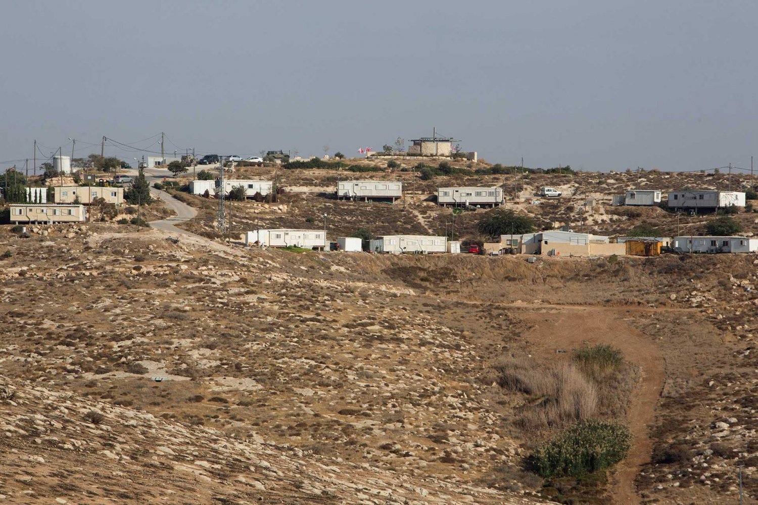
A general view of the Israeli outpost—a wildcat Jewish settlement built on private Palestinian land—of Mitzpe Dani in the occupied West Bank on November 14, 2016, just days before the Israeli Knesset held its first debate on a bill, approved by ministers, aimed at legalizing outposts built on private Palestinian land.
Credit:
Menahem Kahana/AFP via Getty Images
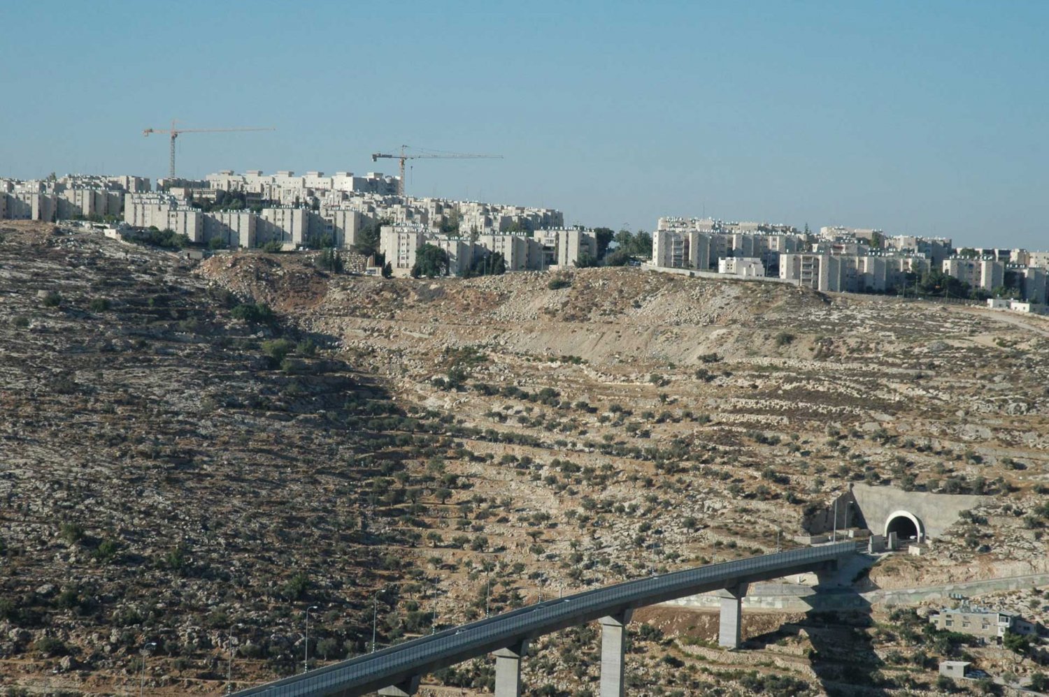
Gush Etzion settlement, overlooking the tunnel and bridge leading from the Jerusalem suburb of Gilo to the West Bank settlements of the Etzion bloc
Credit:
The militaristic imperative: From military outposts to settlements
While the Labor government’s expansionist intentions did not fall far from the imperatives of the Gush Emunim movement, it publicly emphasized a strictly militaristic “defensive” imperative that posited the planning of settlements outside Jerusalem as “security” measures. Within the occupied West Bank, outside municipally controlled Jerusalem, Israel gave itself the ability to declare any land as “state land” for the first 10 years of the occupation on the grounds that it was a “requisition for military needs.”31 Indeed, the construction of settlements on areas ostensibly seized for “security needs” was a common tactic used by the military at the time in order to bypass international law, which banned the practice.32
While “security” justifications were used to illegally build civilian settlements, they were in fact used to create a foundation for civilian settlements with the aim of increasing Jewish demographic and military presence in specific locations across the West Bank. Indeed, the Allon Plan,33 which served as the unofficial guideline for Israeli settlement policy in the West Bank for the first decade of the occupation, followed a territorial agenda that sought the minimal incorporation of Palestinians, in accordance with the demographic imperative. As Allon himself put it, the aim was to gain “maximum security and maximum territory for Israel with a minimum number of Arabs.”34
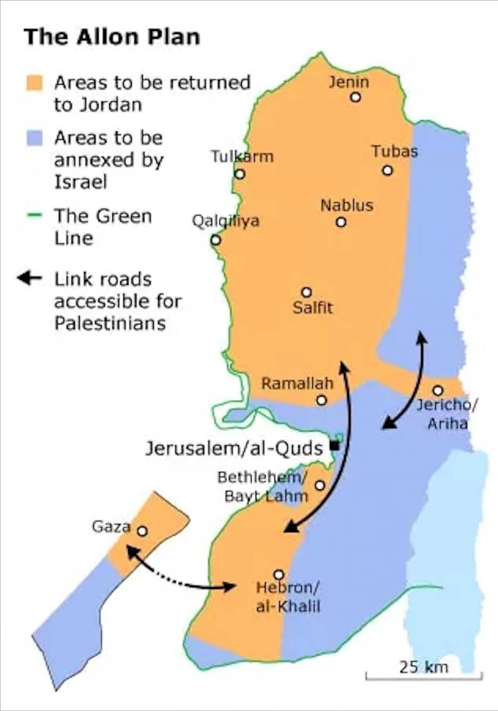
A map of the Allon Plan
Credit:
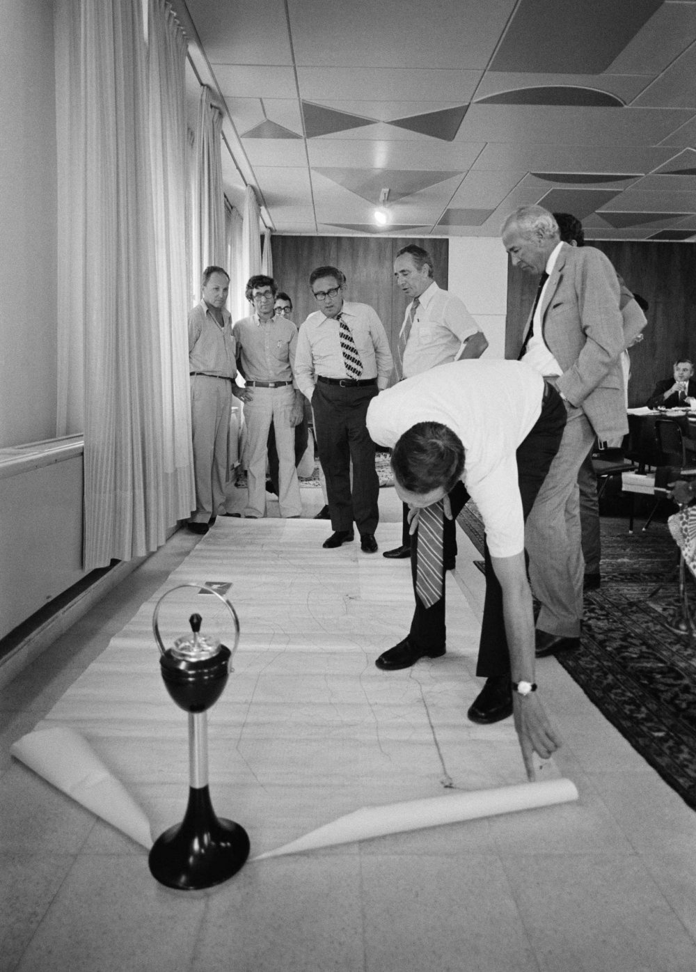
1975: US Secretary of State Henry Kissinger and staff, with Israel’s Prime Minister Shimon Peres and Foreign Minister Yigal Allon in the background, stand on a huge map of the Sinai desert and the Israel-Egypt border on the floor in Israeli Prime Minister Itzhak Rabin’s office in Jerusalem. The map is held down on one end by a standing ashtray.
Credit:
David Hume Kennerly/Getty Images
Moreover, the plan prioritized the colonization of Jerusalem as well as the eastern ridge of the West Bank, utilizing settlement belts as a means of establishing military presence across Palestinian communities, furthering their surveillance and territorial control.35 The geopolitical objectives of these belts were described in annex two of the 1979 United Nations Security Council document, S/13132:
To sever the West Bank Palestinians from East Jordan and to encircle them by creating a cordon on the eastern side. The settlement blocs surrounding Jerusalem are intended to prevent expansion of the Palestinian population of Jerusalem and to psychologically ghettoize them.36
While the Israeli government projected a discourse of “defense” and “security,” the building of settlement belts around Jerusalem was used to intensify the fragmentation and suffocation of Palestinian communities, which in turn also consolidated Israeli military control and domination over the West Bank and its borders.
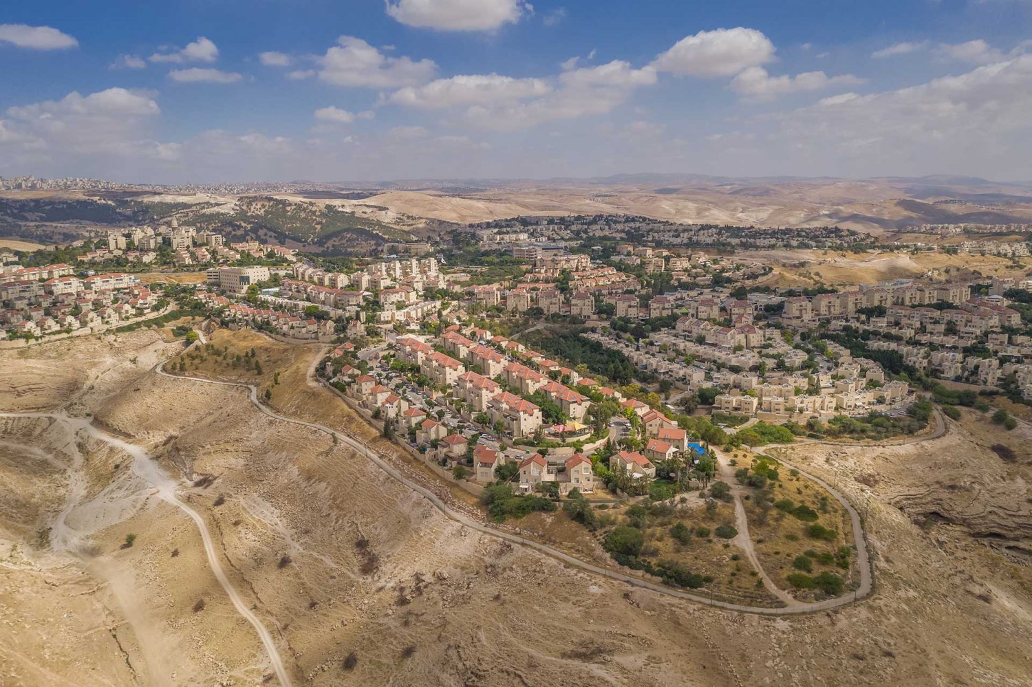
The Allon plan, however, was only a rough guideline, and the actual implementation of settlement construction occurred on hilltops and corridors across the West Bank, especially around Jerusalem. This included the planning and construction of Ma‘ale Adumim, the first major suburban settlement in the West Bank to the east of Jerusalem.
An aerial view of Ma‘ale Adumim settlement, the first major suburban settlement in the occupied West Bank (undated)
Credit:
Shutterstock
To develop Ma‘ale Adumim, Israel cited “security reasons” to expropriate thousands of dunums from the villages of Abu Dis, al-‘Izariyya, al-‘lsawiyya, al-Tur, and ‘Anata. However, the area where Ma‘ale Adumim was built in 1975 had been coveted by Israeli politicians as a target of an urban settlement since 1967, precisely due to its strategic location on a hilltop overlooking the main route between Jericho and Amman on one end, and Jerusalem on the other. The establishment of Ma‘ale Adumim made it possible to connect the settlements in the Jordan Valley to those in East Jerusalem, increasing military presence in the heart of the West Bank, while bifurcating the territory at its narrowest width, thereby precluding the emergence of a contiguous future Palestinian state.
Hilltops were also a priority settlement target for Ariel Sharon, one of the masterminds of settlement planning in the West Bank. Sharon’s expansionist vision saw military confiscation of territories as “a first stage in the domestication and naturalization of the vast Occupied Territories.”37 Sharon developed military settlement planning according to the “defense in depth” doctrine. While he partially depended on the Allon Plan, his strategy sought the positioning of settlements as “independent strongpoints located on hilltops in an area stretching far back from the frontline,” placing them as connected observation points between Palestinian localities spread across the valleys. This “would allow military units to travel between these strongpoints, and, in case of invasion, attack the enemy’s flank and surround it.”38 As Sharon put it, settlers themselves would play a part in this strategy:
In any attack our lines had to be held by limited regular forces in conjunction with the civilian communities whose role is to guard our borders, secure roads, insure communications, and so on . . . [West Bank settlements] would be organized for defence, with their own weapons and ammunition, their contingency plans and their integration into the overall defensive system.39
So, while “security” justifications were cited publicly to build illegal civilian settlements for the purpose of expansion, the settlements themselves continue to serve a function of military surveillance and repression of Palestinians.
Moreover, while the Israeli government and military’s “security reasoning” ostensibly set them apart from the redemptive reasoning of the Gush Emunim movement, they operated hand in hand. The Gush Etzion settlement bloc is a case in point. The mountainous range south of Jerusalem to the east of Bethlehem is central in the religious-Zionist imagination, in part because of its history before the establishment of the state. Groups such as Gush Emunim started to settle that region directly following the 1967 occupation, motivated by a messianic imagination that the site “was the historical cradle of the nation.”40 Indeed, even the Israeli state narratives about settlements like Kfar Etzion and the Gush Etzion bloc describe them “as an exclusive religious-Zionist myth of heroism in the war and especially in the eventual preservation of Jewish Jerusalem.”41 In other words, although the construction of these settlements was spearheaded by ostensibly “rogue” religious movements, in the first years of the occupation, the Israeli military confiscated lands to help them found the settlement bloc of Kfar Etzion. Indeed, even former Israeli prime minister Levi Eshkol took a personal decision to build up the bloc as a Nahal Bloc (military bloc).42
1977 to 1992: Institutionalizing Settlement Policy
In 1977, the Likud party came to power under the right-wing revisionist Zionist leader Menachem Begin. Begin fully supported the settlement of the West Bank, and he allied with religious-Zionist settler movements whose representatives became part of the government.43 Indeed, between 1977 and 1981, the government attempted to transform the “settlement project from an improvised undertaking into an elaborate state project.”44 In practice, this meant promulgating additional laws to confiscate land and implementing widespread settlement plans. In 1979, the government implemented new laws that made it easier to confiscate private and public Palestinian lands.45 And in 1980, it officially annexed East Jerusalem de jure to prevent any future compromise on the area within the expanded Jerusalem municipal boundaries.46
During the Likud party’s second term, Sharon set up the Civil Administration, a military body that has since been given the authority over all settlement development plans in the occupied territories. Ultimately, this mechanism made it possible to bypass most of the bureaucratic limitations on settlement development. Indeed, the Civil Administration was answerable to Sharon himself, who served as defense minister.47 During this period, Sharon introduced “master plans” for settlement expansion in occupied territories.
In addition to the Civil Administration, planning and construction of settlements in the West Bank came under the purview of the Israeli government and global Zionist organizations such the Jewish Agency, the Jewish National Fund, and the World Zionist Organization. This collaboration between a right-wing government, extremist religious groups, and international donors ensured that municipal planning in East Jerusalem promoted “the construction of Jewish settlements” while working “to limit the expansion of Palestinian towns and villages.”48 Settlement activity in Jerusalem and the West Bank under the Likud government thus entered a new phase, and Israel started to establish and expand tens of “suburban” and “rural” settlement blocs on confiscated Palestinian lands around Jerusalem, including outside the city’s municipal boundaries, on land belonging to the Bethlehem governorate. Moreover, by offering subsidized housing, the government has continued to incentivize Jewish Israelis and Jewish immigrants to Israel to move into these settlement blocs.49
In addition, the government gradually adopted and incorporated the religious-Zionist agenda, which meant Gush Emunim was relieved of many of its activities in the larger West Bank. As a result, the 1980s witnessed the refocusing of these religious movements’ efforts to the very heart of Jerusalem, in the Old City and its immediate surroundings, with a host of extremist settler organizations that sought to seize control of Palestinian homes and neighborhoods. Despite the seemingly decentralized organization of these settler organizations, they worked alongside the Israeli government to confiscate Palestinian property, displace Palestinian families from their homes, and replace them with Jewish settlers.
Settler infiltration of Palestinian neighborhoods in and around the Old City
Gush Emunim and other religious-Zionist movements bent on the Judaization of the core of the city had been active in the Old City since the 1970s. These movements followed a model for the Old City that was developed by the Israeli government in 1977 and which encouraged settlers to intrude into the heart of Palestinian neighborhoods in the Old City and around it.50 While private in nature, settler organizations that began to slowly form during the 1980s, such as Elad and Ateret Cohanim, operated as part of the Israeli state’s larger geostrategic effort to create “facts on the ground”—that is, ensuring that there would be no compromise on the city of Jerusalem in any future agreement between Israel and the Palestinians.
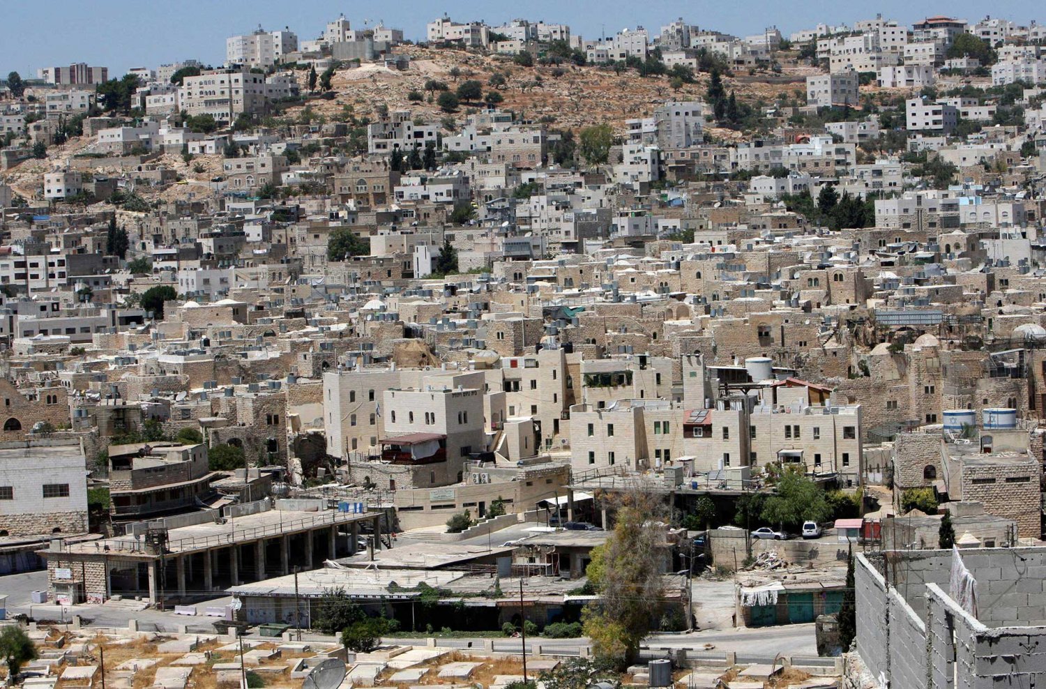
A general view of the Avraham Avinu Jewish settlement in the West Bank city of Hebron August 6, 2008
Credit:
Nayef Hashlamoun, Alamy Stock Photo
Settler activity in Palestinian neighborhoods in Jerusalem was made possible with a host of legislations and amendments that favor the settlers over the original owners of homes.51 That is, after 1977, settlers and the Israeli state began using the Absentee Property Law to confiscate Palestinian properties across East Jerusalem and transfer them to settler organizations. The law was amended multiple times during the 1970s to serve the aims of settler organizations in nullifying Palestinian ownership over property by claiming that they are absentee properties—thus suspending the status of Palestinians living there as “protected tenants” and transferring that property to settler organizations (see Absentees’ Property Law Application in Jerusalem and Forcible Home Expulsions). In addition, with time, the settler organizations expanded financially and structurally, establishing headquarters and splinter organizations globally—thanks to a steady stream of international private funding, especially from the United States, where some of these organizations are based.52 During those years, Ariel Sharon worked tirelessly to further ensure the government’s full endorsement of settlement activity in Palestinian neighborhoods. Indeed, in 1987, Sharon purchased an apartment in the Muslim Quarter—an apartment in which a Palestinian family had lived since 1948—from Ateret Cohanim.53 Though he did not inhabit the home, it was a politically motivated and provocative act aimed at declaring his “core belief that Jews have the right to live anywhere inside the walls of Jerusalem’s contested Old City, even the Muslim Quarter.”54 The act signaled the government’s sanctioning of settlers to move in and establish Jewish presence in these historically Palestinian, densely populated areas.55

The late Ariel Sharon’s apartment in the Muslim Quarter of the Old City of Jerusalem (the old stone house rising tall in the back with the Hannukiah candle stand and the Israeli flag)
Credit:
Sharon’s actions were not only symbolic. Throughout the 1980s, he worked assiduously toward granting full legal sanction and support for these settler organizations, as he implemented a mechanism to ensure “that all relevant government bodies would serve settlers”56—that is, by facilitating the transfer of Palestinian properties to settler organizations. This put in place a process where “private” settler organizations worked hand in hand with a network of Israeli authorities dedicated to the mission of Judaizing the Old City and its surroundings. These state bodies included the ministries of justice, finance, construction and housing, and antiquities, as well as the Israel Land Administration, the Israeli Supreme Court, the Attorney General’s office, the local police, the Development Authority, the Jewish National Fund, Amidar, and local authorities such as the Jerusalem municipality, planning councils, and park administrations.
Since then, the process of expelling Palestinians in Jerusalem from their homes and replacing them with Jewish settlers has been one of coordination between settler groups and state authorities.57 In fact, government bodies and private organizations worked tirelessly to fabricate evidence in order to legally make settlers the “rightful” inheritors of pre-1948 settlements.58 Moreover, the Administrator General’s office, which interpreted “the Protection of Tenants Law in a strict way using every opportunity to take the protected status from the tenants,”59 found many ways to delegitimize Palestinians while at the same time becoming directly involved in planning the development of settlement enclaves in Palestinian neighborhoods.60 Increasingly, the Administrator General’s office, which promotes itself as a supervisor of “public interests,” essentially became the “executive arm of the settler organizations.”61
These movements worked with the municipality to plan and establish a core ring of settlements within and around the Old City. Indeed, while many properties are confiscated ostensibly for their significant attachment to Jewish biblical history, the location of these properties serves to link the Jewish Quarter with the rest of the settlements in around the city. As Nazmi Jubeh writes: “The opening of the tunnel parallel to the Haram[’s] western wall was construed not as an uncovering of a historical site worth visiting, but as an attempt to control what is beneath the ground and to link the settlement sites with each other.”62 The goal of connecting settlement apartments and enclaves across Palestinian neighborhoods was the formation of a core ring of settlements centered around the Jewish Quarter.63 This would establish an interconnected Jewish “bubble” made possible by a network of pathways, touristic parks, cable cars, underground passageways, and even promenades64 (see Three Israeli Settlement Rings in and around East Jerusalem: Supplanting Palestinian Jerusalem).
From the 1990s, settler organizations also started to infiltrate the space around the Old City defined by Israel as the “Holy Basin,” according to a 1974 municipally approved plan that prohibits construction within the area due to its religious, archaeological, and historic significance, and based on Israel’s claim to “conserve it.”65 This included parts of fully built-up Palestinian neighborhoods around the Old City such as Sheikh Jarrah, al-Tur, Silwan, Wadi al-Joz, Ras al-Amud, and Abu Tur.66 Though most of this area is settled by Palestinians in centuries-old residential neighborhoods, it has been placed under the control of different Israeli state, municipal, and local authorities that prohibit residential development within it. As a result, many Palestinian homes built in the area are deemed “illegal” and Israeli authorities regularly carry out demolitions under the guise of preserving the religious and historical significance of the area, and transferring them to settler organizations (see Forcible Home Expulsions).
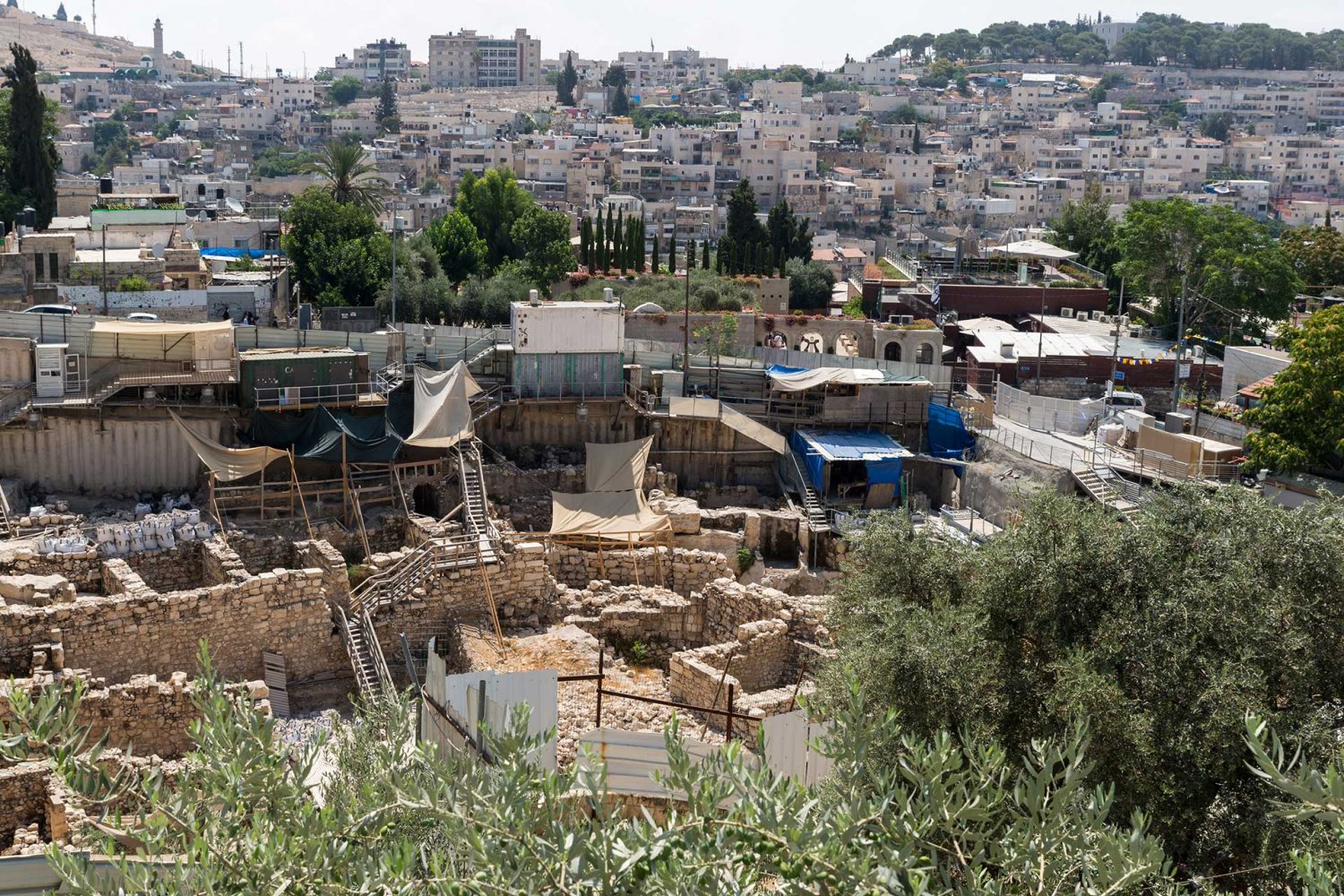
City of David excavations in Silwan, Jerusalem
Credit:
iStock Photo
1977 to 1990: Ariel Sharon’s Expansionist Master Plans
Ariel Sharon was one of the masterminds of settlement planning in the West Bank, including East Jerusalem. To be sure, before the rise of the Likud government, Sharon’s position in the military allowed him to confiscate Palestinian-owned lands as “security measures,”67 and to order the development of military installations and settlements. He also established close ties with the newly born Gush Emunim movement in its early days. Subsequently, and with the new authority he was granted during the Likud’s rule, he was able to “translate [his] military doctrine and the principles of a dynamic battlefield into planning practices of civilian settlements and the creation of political ‘facts on the ground.’”68 In effect, with his new position, the three imperatives of settlement construction and expansion were fused.

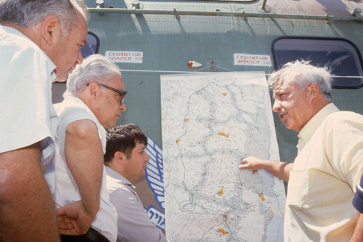
Israeli Minister of Agriculture Ariel Sharon (right) shows Minister of Justice Shmuel Tamir and US Trade Ambassador Robert Strauss a map of West Bank settlements, in Israel, in July of 1979.
Credit:
David Rubinger/Time & Life Pictures/Getty Images
Indeed, from 1977 and through the 1980s, Sharon worked on several settlement plans, briefly reviewed next.
The 1977 Sharon-Wachman Plan
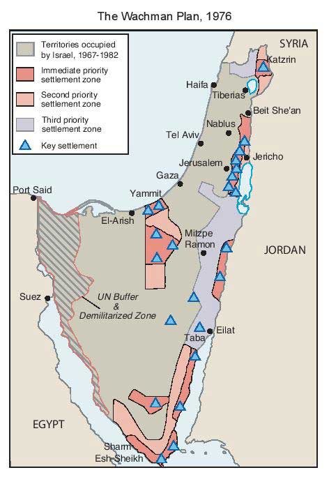
The Wachman Plan, 1976
Credit:
In 1977, Sharon put forth a settlement plan that he adapted from the 1976 Wachman Plan, which had been drawn up by Israeli architect Avraham Wachman. The new plan was oriented toward building a network of “urban, industrial settlements on the ridges overlooking the plain.”69 This plan was militaristic and used settlement belts as “barriers, enveloping the Palestinian-populated mountain region from both east and west, and fragmenting it internally with Israeli east–west traffic corridors and by settlements located on the Palestinian road network.” These barriers aimed “to splice and paralyze” Palestinian space, creating isolated Palestinian cantons and individual settlements as observation points. As a result, from these settlements, Israel would be able to overlook “their surroundings, main traffic arteries, strategic road junctions and Palestinian cities, towns and villages.”70 The roads that facilitated this military control also became instruments of development71—thus aligning with the government’s newly adopted project of industrial expansion and suburban colonization in the West Bank, exemplified by the development of the Outer Ring of Jerusalem settlements.
It is important to note that Sharon’s geopolitical interests coincided with, and were affected by, the principles of the religious settler movement rising at the time.72 Indeed, while Sharon organized settlements according to the “military-strategic or economic-suburban logic” during the Likud government, he also prioritized the religious-Zionist agenda of Gush Emunim, which focused on hilltops as well as localities that are near Palestinian localities “in order to naturalise the Jewish people as a healthy nation sitting safely in all its land.”73
The 1981 Gush-Drobles and Sharon Plans
In 1981, Sharon adapted the Gush-Drobles vision to a new plan known as the “Sharon Plan,” which became the Likud’s blueprint for settlement construction throughout the 1980s. Drafted by the head of the World Zionist Organization’s Land Settlement Department, who was himself a Gush Emunim loyalist, the Drobles Plan states that the “disposition of settlements must be carried out not only around the settlements of the minorities [Palestinians], but also in between them.” The reasoning behind this is explained in the first principle guiding the plan: “Settlement throughout the entire Land of Israel is for security and by right. A strip of settlements at strategic sites enhances both internal and external security alike, as well as making concrete and realizing our right to Eretz-Israel.”74 Hence, even before it was adopted, the plan merged both the imperative to Judaize Palestinian territories as well as to impose military power through the construction of settlements inhabited by extremist armed settlers around and between Palestinian neighborhoods, with the intention of rendering them besieged, fragmented, and powerless.75
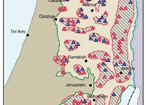
As part of the 1981 plan, Sharon also adopted and expanded the Gush Emunim mission to connect “all existing settlements and 57 new ones into blocs controlling arterial routes, ridges and water sources, breaking up Palestinian demographic continuity.” As a result, “cities were encapsulated, while settlement control over west-east corridors to the Jordan Rift paralyzed Palestinian communication in a design meant to rule out forever any type of OPT [Occupied Palestinian Territories] autonomy.” He further modified the plan by incorporating into it the suburban priorities for “settlements with immediate territorial unity and overall contiguity with Israel’s coastal plain.”76 In other words, while incorporating the interests of Gush Emunim, the plan also focused on investing in infrastructure and services aimed at incentivizing tens of thousands of settlers to move into the suburban blocs.
By the end of the Likud government’s first term in power in 1981, the government rapidly increased settlement construction in and around East Jerusalem. Indeed, the number of settlements more than doubled from 30 to 68 between 1977 and 1981, and the number of settlers almost quadrupled, reaching 16,200.77 And within only two years after Sharon’s 1981 plan, the settler population had nearly doubled again.78
During the second half of the 1980s and after the government’s transition from the right-wing Likud party to the Labor party in 1984, the settlement enterprise kept expanding with the same underlying principles, and with the incorporation of more para-state and private institutions into planning and construction. With Sharon serving as Minister of Industry, Trade, and Labor between 1984 and 1990, the plan was in full swing, and by 1991, the number of settlers had increased substantially, with roughly 100,000 of the 185,000 settlers living in the areas targeted by the 1981 plan.79
In addition to increased settler numbers, the settlements built during these years significantly furthered the Judaization of Jerusalem and the fragmentation of Palestinian spaces in and around Jerusalem. In 1983, the Israeli government expanded the major settlements around Jerusalem, including the recognition of the Giv‘at Ze’ev settlement outpost to the northwest of Jerusalem as its own local council, which later developed its own settlement bloc around it. In 1985, Beitar Illit, a major Haredi settlement, was built to the south of Jerusalem in the Gush Etzion bloc. With this, East Jerusalem was flanked to the north, south, and east by major settlement blocs that developed their own jurisdictional capacities, networks of bypass roads, commercial centers, and a chain of nonresidential settlements. In 1991, Ma‘ale Adumim became its own city council.
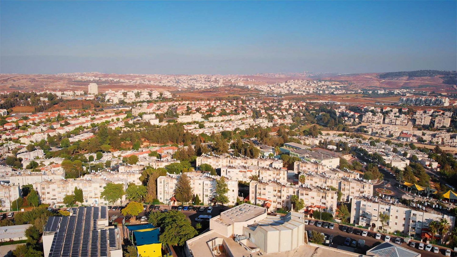
An aerial overview of the Israeli settlement Giv‘at Ze’ev in the occupied West Bank
Credit:
Shutterstock
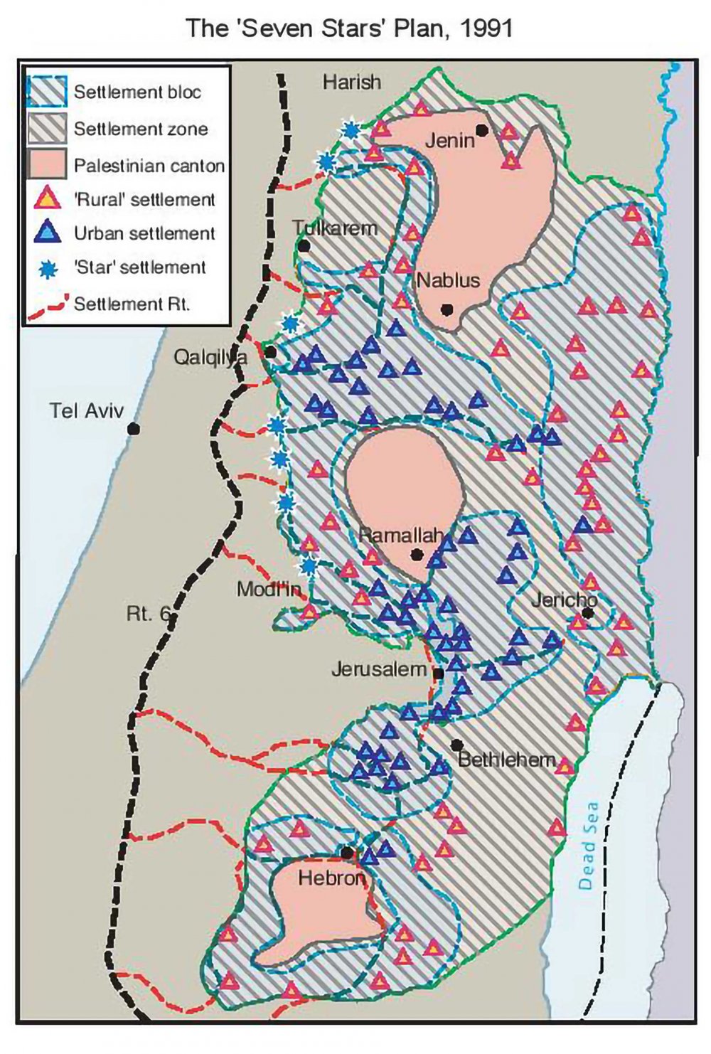
The Seven Stars Plan, 1991
Credit:
Serving as the Minister of Construction and Housing in 1990, Sharon developed the Seven Stars Plan,80 which was approved by the Knesset in May 1991 to become the official state settlement policy. This plan “served the dual purpose of binding the central West Bank settlements to an industrialized belt of new development towns, while eroding the demography and geography of the Green Line.” That is, on the one hand, the plan separated the West Bank into three fragmented Palestinian cantons, leaving Palestinians without any contiguous populated areas and therefore autonomy around Jerusalem. On the other, it secured territorial contiguity between the Israeli settlement blocs surrounding Jerusalem in the Outer Ring and connected them to other settlement blocs in the West Bank. And in accordance with Israel’s vision for Metropolitan Jerusalem, the settlements were also connected to the core of the city and onward to the coastal plain beyond the Green Line (see Israel’s Vision of a Greater [Jewish] Jerusalem). This plan, which became a “national development program,” reflected the Israeli state’s use of settlements in the service of “destroying forever any possibility of Palestinian territorial or demographic contiguity,”81 and hence, any future Palestinian state with its capital in Jerusalem.
Notes
1
Yossi Katz, “The Reemergence of Jerusalem: New Zionist Approaches in Attaining Political Goals, Pre-1914,” Political Geography 14, no. 3 (1995): 284; Yossi Katz, “The Palestinian Mountain Region and Zionist Settlement Policy 1882–1948,” Middle Eastern Studies 30, no. 2 (1994): 312–13; Yossi Katz, “The Political Status of Jerusalem in Historical Context: Zionist Plans for the Partition of Jerusalem in the Years 1937–1938,” Shofar: An Interdisciplinary Journal of Jewish Studies 11, no. 3 (1993): 46.
2
“Chapter 3: Israeli Settlements and International Law,” Amnesty International.
3
The term “facts on the ground” was first used in the late 1970s during the rule of the first Likud government, which oversaw extensive settlement policy enaction. See Josiah Ober, “Solon and the Horoi: Facts on the Ground in Archaic Athens,” in Solon of Athens: New Historical and Philological Approaches, ed. Josine H. Blok and André P. M. H. Lardinois (Leiden: Brill, 2006), 442.
4
Eyal Weizman, Hollow Land: Israel’s Architecture of Occupation (London: Verso, 2007), 87.
5
Weizman, Hollow Land, 88.
6
Weizman, Hollow Land, 93–95.
7
Meron Benvenisti, City of Stone: The Hidden History of Jerusalem (Berkeley: University of California Press, 1996), 65.
8
Bimkom and B’Tselem, The Hidden Agenda: The Establishment and Expansion Plans of Ma’ale Adumim and Their Human Rights Ramifications (Jerusalem: Bimkom-B’Tselem, 2009), 12.
9
Yotam Ben Hillen, “The Legal Status of East Jerusalem,” Norwegian Refugee Council, December 2013.
10
Charlie Hoyle, “Interactive Timeline: The History of Israeli Settlements since 1967,” November 20, 2019.
11
Inter-ministerial Committee to Examine the Rate of Development for Jerusalem, Recommendation for a Coordinated and Consolidated Rate of Development [in Hebrew], Jerusalem, August 1973, 3.
12
Amir Cheshin, Bill Hutman, and Avi Melamed, Separate and Unequal: The Inside Story of Israeli Rule in East Jerusalem (Cambridge, MA: Harvard University Press, 2001), 32.
13
Hagit Ofran, “Annex and Dispossess: Use of the Absentees’ Law to Dispossess Palestinians of Their Property in East Jerusalem,” Peace Now, June 2020.
14
B’Tselem, “Land Grab: Israel’s Settlement Policy in the West Bank,” May 2002.
15
Nazmi Jubeh, “Jewish Settlement in the Old City of Jerusalem after 1967,” Palestine–Israel Journal (2001).
16
Bracha Slae, Ruth Kark, and Naom Shoval, “Post-war Reconstruction and Conservation of the Historic Jewish Quarter in Jerusalem, 1967–1975,” Planning Perspectives 27, no. 3 (2012): 369–92.
17
Cited in Bimkom and B’Tselem, The Hidden Agenda, 12.
18
Weizman, Hollow Land, 284n3.
19
Ben Hillen, “The Legal Status of East Jerusalem.”
20
Ben Hillen, “The Legal Status of East Jerusalem.”
21
Bimkom and B’Tselem, The Hidden Agenda, 11–12.
22
Donald S. Will, “Zionist Settlement Ideology and Its Ramifications for the Palestinian People,” Journal of Palestine Studies 11, no. 3 (1982): 41. Kook was the son of Rabbi Avraham Yitzhak Hacohen Kook, with whom he developed Kookian Zionism, which became the dominant form of religious Zionism.
23
Michael Dumper, “Israeli Settlement in the Old City of Jerusalem,” Journal of Palestine Studies 21, no. 4 (1992): 41–42.
24
Assaf Gavron, “Ofra, the Mayflower of the Settlements,” Tablet, December 4, 2019.
25
Weizman, Hollow Land, 95.
26
Will, “Zionist Settlement Ideology,” 42.
27
Will, “Zionist Settlement Ideology,” 42.
28
Will, “Zionist Settlement Ideology,” 42.
29
Weizman, Hollow Land, 89–90. See also David Ohana, “Kfar Etzion: The Community of Memory and the Myth of Return,” Israel Studies 7, no. 2 (2002): 145–74.
30
Israeli Annexation The Case of Etzion Colonial Bloc, Badil Resource Center for Palestinian Residency and Refugee Rights, July 2019.
31
Bimkom and B’Tselem, The Hidden Agenda, 10.
32
Yotam Berger, “Israel Used Military Censor to Conceal First Settlements From Public, Document Reveals,” Haaretz, September 7, 2016.
33
The Allon Plan was named after former Labor minister Yigal Allon, who presented it to former prime minister Levi Eshkol shortly after the war on July 26, 1967.
34
Weizman, Hollow Land, 58.
35
Weizman, Hollow Land, 101.
36
Will, “Zionist Settlement Ideology,” 43.
37
Weizman, Hollow Land, 66, 105.
38
Weizman, Hollow Land, 62–63.
39
Weizman, Hollow Land, 84.
40
Dror Greenblum, “The Making of a Myth: The Story of Kfar Etzion in Religious Zionism 1948–1967,” Israel Studies 21, no. 1 (2016): 142.
41
Greenblum, “The Making of a Myth,” 133.
42
BADIL Resource Center for Palestinian Residency and Refugee Rights, Israeli Annexation: The Case of Etzion Colonial Bloc [in Arabic] (Bethlehem: BADIL Resource Center for Palestinian Residency and Refugee Rights, 2019), 35 [translated from Arabic by the author].
43
Weizman, Hollow Land, 95, 107.
44
Weizman, Hollow Land, 111.
45
Weizman, Hollow Land, 116.
46
“Basic Law: Jerusalem, Capital of Israel,” Israel Ministry of Foreign Affairs, July 30, 1980.
47
William Claiborne, “Israel’s Sharon Backs Civil Rule for West Bank,” Washington Post, September 25, 1981.
48
Weizman, Hollow Land, 121.
49
Weizman, Hollow Land, 122–25.
50
Nadia Abu El-Haj, Facts on the Ground: Archaeological Practice and Territorial Self-fashioning in Israeli Society (Chicago: University of Chicago Press, 2002), 232.
51
For examples of exploitation of Israeli laws for settlers’ benefit, including the 1972 Israeli Tenants Protection Law, see Dumper, “Israeli Settlement in the Old City,” 41.
52
Uri Blau, “From N.Y.C. to the West Bank: Following the Money Trail That Supports Israeli Settlements,” Haaretz, December 7, 2015.
53
Thomas Friedman, “In Jerusalem, Sharon Apartment Creates a Stir,” New York Times, December 31, 1987.
54
Friedman, “In Jerusalem, Sharon Apartment Creates a Stir.”
55
George Moffett, “Israel’s Sharon Sparks Controversy in Jerusalem,” The Christian Science Monitor, December 16, 1987.
56
Ofran, “Annex and Dispossess.”
58
Nir Hasson, “The Judaization of an East Jerusalem Neighborhood Gains Steam,” Haaretz, November 2, 2015.
59
“Systematic Dispossession.”
60
“Systematic Dispossession.”
61
Nir Hasson, “The Executive Arm of the Settler Organizations,” Haaretz, December 15, 2021.
62
Jubeh, “Jewish Settlement in the Old City.”
63
“Israel Seeking to Establish 50km Settlement Belt in Jerusalem,” International Middle East Media Center, November 23, 2018.
64
Nir Hasson, “Jerusalem Plans Promenade Connecting Settler Homes in Palestinian Neighborhood,” Haaretz, February 8, 2018.
65
“Israel Seeking to Establish 50km Settlement Belt.”
66
Wendy Pullan and Maximilian Sternberg, “The Making of Jerusalem’s ‘Holy Basin,’” Planning Perspectives 27, no. 2 (2012): 239.
67
Weizman, Hollow Land, 105.
68
Weizman, Hollow Land, 63.
69
Weizman, Hollow Land, 80.
70
Weizman, Hollow Land, 81.
71
Weizman, Hollow Land, 81.
73
Weizman, Hollow Land, 94.
74
Will, “Zionist Settlement Ideology,” 45.
75
Will, “Zionist Settlement Ideology,” 49.
76
“Israeli Settlement Master Plans, 1976–1991.”
77
Weizman, Hollow Land, 92.
78
Weizman, Hollow Land, 122–25.
79
“Israeli Settlement Master Plans, 1976–1991.”
80
Gabriel Schwake, “Supply-Side Territoriality: Reshaping a Geopolitical Project according to Economic Means,” Space and Polity 25, no. 1 (2021): 75–96.
81
“Israeli Settlement Master Plans, 1976–1991.”